This map of the Niagara Thruway displays markers for exits and tolling points, which you can select to get a close-up map of that point of interest or location.
The points-of-interest shown on this map are also listed below, ordered from south to north.
See below for more comprehensive information about the Niagara Thruway
This state toll road serves several key cities, including Buffalo, Niagara Falls, Grand Island, and Lewiston.
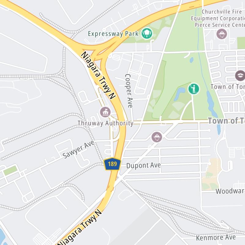
The static map seen here shows a segment of The Niagara Thruway at Kenmore Avenue / Sheridan Dr/Grand Isl Blvd. The entirety of The Niagara Thruway can be seen in the fully-interactive map above, which includes linked markers. You may resize and reposition the interactive map to orient the road in relation to other landmarks.
There is also a complete list of exits below.
Tolls For Cars, SUVs, Pickups, etc.
▹ Grand Island barriers, as of January 1, 2024.
The total toll for using the Niagara Thruway is $1.75, if you are using a compatible transponder, RFID sticker or other pass. Using a New York-issued transponder, the rate is $1.00.
NOTE: The rates shown are the maximum toll incurred. Your trip may have a lower rate.
For drivers paying with a transponder, the following passes will work on the Niagara Thruway
Learn about transponders and accounts in New York.
Without a compatible pass or transponder, the toll will be $1.75.
View MapAll Tolls / Calculator ▸
Our new toll and trip calculator is being constructed. For most roads, you can still use the legacy calculator for current, accurate tolls.
Turnpikes.com has partnered with Tiqets.com to bring you these excusive deals on attractions!
No alerts to display at this time.
Selecting an exit or other location opens a separate map with locations of available gas, EV charging, fast-food and other dining options. Current weather and driving conditions will also be shown.
I–90/NYS Thruway — Cheektowaga
Note(s): None.
GPS 42.874824000 X -78.788074000
New York State Thruway Authority manages this segment.
Exit 1Ogden Street / Dingens Street — Buffalo
Note(s): None.
GPS 42.876352000 X -78.801255000
New York State Thruway Authority manages this segment.
Exit 2Clinton Street / Bailey Avenue — Buffalo
Note(s): None.
GPS 42.872023000 X -78.816543000
New York State Thruway Authority manages this segment.
Exit 3Seneca Street — Buffalo
Note(s): None.
GPS 42.868039000 X -78.827794000
New York State Thruway Authority manages this segment.
Exit 4Smith Street / Fillmore Avenue — Buffalo
Note(s): None.
GPS 42.870856000 X -78.845186000
New York State Thruway Authority manages this segment.
Exit 5 NBHamburg Street — Buffalo
Note(s): None.
GPS 42.873408000 X -78.857519000
New York State Thruway Authority manages this segment.
Exit 5 SBLouisiana Street — Buffalo
Note(s): None.
GPS 42.875545000 X -78.863358000
New York State Thruway Authority manages this segment.
Exit 6Elm Street / Baseball Stadium — Buffalo
Note(s): None.
GPS 42.877137000 X -78.871423000
New York State Thruway Authority manages this segment.
Exit 7 SBBuffalo Skyway — Buffalo
Note(s): No NB Off
GPS 42.879887000 X -78.878832000
New York State Thruway Authority manages this segment.
Exit 7 NBChurch Street / to Buffalo Skyway — Buffalo
Note(s): No SB Off
GPS 42.884282000 X -78.883734000
New York State Thruway Authority manages this segment.
Exit 8Niagara Street — Buffalo
Note(s): None.
GPS 42.889860000 X -78.889243000
New York State Thruway Authority manages this segment.
Exit 9Porter Avenue / Peace Bridge — Buffalo
Note(s): to Fort Erie, Canada
GPS 42.898376000 X -78.897728000
New York State Thruway Authority manages this segment.
Exit 11Scajaquanda Expressway/NY 198 — Buffalo
Note(s): None.
GPS 42.928214000 X -78.898565000
New York State Thruway Authority manages this segment.
Exit 12Amherst Street/Tonowanda Street — Buffalo
Note(s): SB On/NB Off
GPS 42.933378000 X -78.902601000
New York State Thruway Authority manages this segment.
Exit 13Austin Street — Buffalo
Note(s): SB Off/NB On
GPS 42.937867000 X -78.905053000
New York State Thruway Authority manages this segment.
Exit 14 SBOntario Street — Buffalo
Note(s): SB Off/NB On
GPS 42.946319000 X -78.908934000
New York State Thruway Authority manages this segment.
Exit 14 NBVulcan Street — Buffalo
Note(s): NB Off Only
GPS 42.951625000 X -78.909257000
New York State Thruway Authority manages this segment.
Exit 15Sheridan Drive / Kenmore Avenue — Buffalo
Note(s): No NB On
GPS 42.970257000 X -78.914998000
New York State Thruway Authority manages this segment.
Exit 15Kenmore Avenue / Sheridan Dr/Grand Isl Blvd — Tonawanda
Note(s): No NB Off
GPS 42.980530000 X -78.909951000
New York State Thruway Authority manages this segment.
Exit 16I–290/Youngmann Memorial Hwy — Tonawanda
Note(s): None.
GPS 42.986954000 X -78.914623000
New York State Thruway Authority manages this segment.
Exit 17River Road/NY 266 — Tonawanda
Note(s): None.
GPS 42.996078000 X -78.932222000
New York State Thruway Authority manages this segment.
Old South Grand Island Bridge Barrier — Tonawanda
Note(s): (Barrier removed)
GPS 42.994438000 X -78.929315000
New York State Thruway Authority manages this segment.
South Grand Island Toll Gantry — Tonawanda
Note(s): Replaced Old South Grand Island Barrier
GPS 43.002492000 X -78.943292000
New York State Thruway Authority manages this segment.
Exit 18AGrand Island Boulevard — Grand Island
Note(s): NB On/NB Off
GPS 43.003817000 X -78.945597000
New York State Thruway Authority manages this segment.
Exit 18/18BBeaver Island State Park — Grand Island
Note(s): No NB On
GPS 43.005648000 X -78.949397000
New York State Thruway Authority manages this segment.
Exit 19Whitehaven Road — Grand Island
Note(s): None.
GPS 43.021593000 X -78.974339000
New York State Thruway Authority manages this segment.
Exit 20/20BLong Road / Grand Isl Blvd — Grand Island
Note(s): None.
GPS 43.048509000 X -78.990369000
New York State Thruway Authority manages this segment.
Exit 20AWest River Parkway — Grand Island
Note(s): No NB Off
GPS 43.053699000 X -78.990631000
New York State Thruway Authority manages this segment.
North Grand Island Bridge Toll Gantry — Grand Island
Note(s): SB gantry replaced old barrier
GPS 43.058108000 X -78.990611000
New York State Thruway Authority manages this segment.
Exit 21Niagara Scenic Parkway / Buffalo Avenue — Niagara Falls
Note(s): Sceneic route to Rainbow Bridge to Canada
GPS 43.074221000 X -78.990636000
New York State Thruway Authority manages this segment.
Exit 21ALa Salle Expressway — Niagara Falls
Note(s): None.
GPS 43.080710000 X -78.990637000
New York State Thruway Authority manages this segment.
Exit 22Niagara Falls Boulevard — Niagara Falls
Note(s): To Rainbow Bridge to Canada - left at Packard, then right at Ferry
GPS 43.089638000 X -78.990257000
New York State Thruway Authority manages this segment.
Exit 23Packard Road / NY 182 / Porter Road — Niagara Falls
Note(s): None.
GPS 43.107049000 X -78.989118000
New York State Thruway Authority manages this segment.
Exit 24NY 31 / Whitmer Road — Niagara Falls
Note(s): None.
GPS 43.130168000 X -79.018426000
New York State Thruway Authority manages this segment.
Exit 25ANY 265/Military Road — Lewiston
Note(s): NB Off Only
GPS 43.150154000 X -79.027839000
New York State Thruway Authority manages this segment.
Exit 25BNY 104 / Upper Mtn Rd / Lewiston Road — Lewiston
Note(s): Last US exit before Lewiston-Queenston bridge
GPS 43.151391000 X -79.031172000
New York State Thruway Authority manages this segment.
Lewiston-Queenston Bridge — Lewiston
Note(s): to Canada
GPS 43.152332000 X -79.038369000
New York State Thruway Authority manages this segment.
Journey to key destinations around and adjacent to New York!
Communities in this metro area include Bronx, Brooklyn, Manhattan, New York City, Rockaway, Far Rockaway, Atlantic Beach, Queens, Staten Island, Elizabeth, New Jersey, Fort Lee, New Jersey, Newark, New Jersey, Union City, New Jersey, New Rochelle, and Perth Amboy, New Jersey.
Individual toll maps for this region are listed below.
Communities in this metro area include Poughkeepsie, Newburgh, Middletown, Kingston, Hudson, and Catskill.
Individual toll maps for this region are listed below.
Communities in this metro area include Albany, Schenectady, Rotterdam, Amsterdam, and West Stockbridge, Massachusetts.
Individual toll maps for this region are listed below.
Communities in this metro area include Syracuse, East Syracuse, Oneida, Utica, Rome, Frankfort, and Watertown.
Individual toll maps for this region are listed below.
Communities in this metro area include Buffalo, Batavia, Rochester, Amherst, Niagara Falls, and Niagara Falls, Ontario.
Individual toll maps for this region are listed below.
Communities in this metro area include New Haven, Bridgeport, Darien, Greenwich, Stamford, and Port Chester, New York.
Individual toll maps for this region are listed below.
Communities in this metro area include Scranton, Wilkes Barre, Stroudsburg, Clarks Summit, and Knowlton Township, New Jersey.
Individual toll maps for this region are listed below.
Communities in this metro area include Toronto, Niagara Falls, Hamilton, and Mississauga.
Individual toll maps for this region are listed below.