Niagara Thruway At Niagara Falls Boulevard

Niagara Falls Boulevard

At A Glance

This is Exit 22 of the Niagara Thruway.

This junction is located in Niagara Falls. To Rainbow Bridge to Canada - left at Packard, then right at Ferry.

This location is in the Buffalo - Rochester - Niagara Falls area.

▾ Interactive Map Below ▾

This location's approximate GPS Coordinates are 43.08964 x -78.99026.

Which directions can I travel from here?

From this junction, traffic can enter traveling both southbound and northbound. Traffic can also exit traveling both southbound and northbound.

On to Packard Road / NY 182 / Porter Road, about 1.5 miles away ►

◄ Back to La Salle Expressway, about 0.7 miles away.

Which direction are tolls charged here?

Tolls are not charged or collected at this junction.
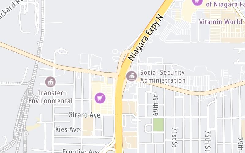
▾ Travel Conditions ▾

Above: Map image © TomTom Intl BV

Using The POI Map

The interactive map and lists on this page include key traveler services within two miles of this destination point.

You will find common services, including gas stations, truck stops, EV charging facilities, fast-food or family restaurants, and hotels. These are displayed on the interactive map as markers, which you can select for more information.

Current driving conditions and weather, along with a more complete list of key services, may be found below the map.

View Map ▾Weather ▾

Static map of Niagara Thruway at Niagara Falls Boulevard
Static map. Interactive map is below.

The interactive map shows dining and services near your chosen location: Niagara Falls Boulevard and the Niagara Thruway. A detailed summary of food and services around here is shown after the map.

View Map ▾

Advertising
Advertising

Interactive Exit Map With Nearby Gas, Food And Lodging

Area Map & Services Up To Two (2) Miles

Pan and zoom the map as you desire, and select markers for information and other options, including online ordering, where available.

Advertising
Advertising

Travel Conditions At Niagara Falls Boulevard

Current Weather And Visibility

  • 22 7 03
  • Partly Sunny

    50°F / 10.2°C

    Feels Like:

    45°F / C

  • Visibility

    12 Mi / 19.3 Km

    3-Hour Precip:

    0 In / 0.0 Cm

  • Southwest
    Winds (SW)

    10.3 MPH / 16.5 KPH

    Gusts:

    19.7 MPH / 31.6 KPH

▸ Get the full forecast for This Location | The Buffalo - Rochester - Niagara Falls area

Available Cameras

I-190 @ NIAGARA FALLS BLVD

I-190 @ NIAGARA FALLS BLVD

Camera Direction: UNKNOWN. Source: NYSDOT - Buffalo 14304

Cameras Closest To Niagara Falls Boulevard

Camera Direction: UNKNOWN. Source: NYSDOT - Buffalo 14304

115 Ft

Camera Direction: SOUTH. Source: NYSDOT - Buffalo 14304

0.64 Mi

Camera Direction: NORTH. Source: NYSTA - Buffalo 14304

0.99 Mi

Camera Direction: UNKNOWN. Source: NYSDOT - Buffalo 14304

1.19 Mi

Camera Direction: UNKNOWN. Source: NYSDOT - Buffalo 14304

1.20 Mi

Travel Pictures

No photos …

There are no currently-available photos for this location.

Advertising
Advertising

Food, Gas, EV And Other Services Near Niagara Falls Boulevard

Fuel, EV and convenience store header

Gas & EV Charging

Closest Gas Stations

TOPS FRIENDLY MARKET

7200 Niagara Falls Boulevard • 0.41 miles

Store/Fuel Brand: Tops

DELTA SONIC

7920 Niagara Falls Boulevard • 0.85 miles

Store/Fuel Brand: Delta Sonic

SAM'S CLUB

1580 Military Rd • 0.86 miles

Store/Fuel Brand: Sam's Club

MINITZ BUFFALO AVE

6302 Buffalo Avenue • 0.93 miles

Store/Fuel Brand:

View Map ▴Full List ▾

Closest EV Chargers

EVOLVE NY: NIAGARA FALLS

7200 Niagara Falls Boulevard • 0.47 miles

CONNECTOR: Chademo
POWER: 150 KW @ 400 V
CURRENT: 375 Amp DC

MACERICH FASHION OUTLETS OF NIAGARA FALLS

1805 Fashion Outlet Boulevard • 0.67 miles

CONNECTOR: IEC62196Type1CCS
POWER: 150 KW @ 400 V
CURRENT: 375 Amp DC

CHARGEPOINT

1536 Military Road • 0.93 miles

CONNECTOR: IEC62196Type1
POWER: 6 KW @ 240 V
CURRENT: 27 Amp AC1

FORD CHARGE - BASIL FORD OF NIAGARA FALLS

6980 Niagara Falls Boulevard • 1,527 feet

CONNECTOR: IEC62196Type1CCS
POWER: 50 KW @ 400 V
CURRENT: 125 Amp DC

View Map ▴Full List ▾

Coffee, snacks and dining header

Fast Food & Beverage

Closest Fast Food

Fast food refers ONLY to quick-service and take-out diners. All restaurant types are shown on the map below.

PAPA JOHN'S

7101 Niagara Falls Boulevard • 0.40 miles

BROADWAY PIZZA

7320 Niagara Falls Boulevard • 0.48 miles

Taco Bell

TACO BELL

7300 Niagara Falls Boulevard • 0.49 miles

BURGER KING

BURGER KING

7403 Niagara Falls Boulevard • 0.59 miles

Wendy's

WENDY'S

7515 Niagara Falls Boulevard • 0.63 miles

LAROSA PIZZA

Fashion Outlet Boulevard • 0.79 miles

CHARLEYS PHILLY STEAKS

1994 Military Road • 0.81 miles

JERSEY MIKE'S SUBS

1550 Military Road • 0.88 miles

View Map ▴Full List ▾

Hotels and destinations header

Hotels & Airports

Destination Travel

Discover New York Attractions

Advertising
Advertising

Services Within Two Miles

Lists Include Fuel, EV Charging and Fast Food

Select/Tap Vendors For Info

Open the columns below to show address, phone numbers and available URLs for gas stations, EV charging stations and fast-food dining within about two miles of Niagara Falls Boulevard and the Niagara Thruway.

▾ Open For Full Lists ▾

EXPLORE NEW YORK

Journey to key destinations around and adjacent to New York!

Map Of This Region ▹

Communities in this metro area include Poughkeepsie, Newburgh, Middletown, Kingston, Hudson, and Catskill.

Individual toll maps for this region are listed below.

Map Of This Region ▹

Communities in this metro area include Albany, Schenectady, Rotterdam, Amsterdam, and West Stockbridge, Massachusetts.

Individual toll maps for this region are listed below.

Map Of This Region ▹

Communities in this metro area include Syracuse, East Syracuse, Oneida, Utica, Rome, Frankfort, and Watertown.

Individual toll maps for this region are listed below.

Map Of This Region ▹

Communities in this metro area include Buffalo, Batavia, Rochester, Amherst, Niagara Falls, and Niagara Falls, Ontario.

Individual toll maps for this region are listed below.

Map Of This Region ▹

Communities in this metro area include New Haven, Bridgeport, Darien, Greenwich, Stamford, and Port Chester, New York.

Individual toll maps for this region are listed below.

Map Of This Region ▹

Communities in this metro area include Scranton, Wilkes Barre, Stroudsburg, Clarks Summit, and Knowlton Township, New Jersey.

Individual toll maps for this region are listed below.

Map Of This Region ▹

Communities in this metro area include Toronto, Niagara Falls, Hamilton, and Mississauga.

Individual toll maps for this region are listed below.

Advertising
Advertising
Turnpikes.com is proud to partner with the following: