This Location At A Glance
This is Exit 59 of the New York State Thruway.
This junction is located in Dunkirk. Fredonia is nearby. NOTE: NYSTA Interchange ID: m59x.
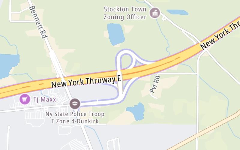
This location's approximate GPS Coordinates are 42.46210 x -79.30580.
Which directions can I travel from here?
From this junction, traffic can enter traveling both eastbound and westbound. Traffic can also exit traveling both eastbound and westbound.
On to NY Route 394 / Westfield / Mayville, about 17.3 miles away ►
◄ Back to NY Routes 5, 20 & 438 / Silver Creek / Irving, about 12.2 miles away.
Nearby gas and food are shown on the interactive map below.
Weather & Visibility

A Shower
47°F / 8.1°C
Feels Like
40°F / 4.3°C

Visibility
11 Mi / 17.7 Km
3 Hr Precip
0.01 In / 0.0 Cm

-
W Wind
8.7 Mi / 14.1 Km
Gusts
13 Mi / 20.9 Km
See the full forecast for This Location
Conditions and forecasts provided in partnership with AccuWeather.

Weather provided in partnership with AccuWeather.
Available Cameras

128 Ft


 Bayonne Bridge ▹
 Goethals Bridge ▹
 Holland Tunnel ▹
 Garden State Parkway ▹
 George Washington Bridge ▹
 Lincoln Tunnel ▹
 New Jersey Turnpike ▹
 Outerbridge Crossing ▹
 Bronx Whitestone Bridge ▹
 Hugh L Carey Tunnel ▹
 Cross Westchester Expressway ▹
 Robert F Kennedy Bridge ▹
 Queens Midtown Tunnel ▹
 New England Thruway ▹
 New York State Thruway ▹
 Throgs Neck Bridge ▹
 Henry Hudson Bridge ▹
 Atlantic Beach Bridge ▹
 Marine Parkway Bridge ▹
 Connecticut Turnpike ▹
 Bear Mountain Bridge ▹
 Massachusetts Turnpike ▹
 Thousand Islands Bridge ▹
 Niagara Thruway ▹
 Peace Bridge ▹
 Rainbow Bridge ▹

 Pennsylvania Turnpike ▹
 Milford Montague Toll Bridge ▹
 Delaware Water Gap Toll Bridge ▹
 Portland Columbia Toll Bridge ▹
 Easton Phillipsburg Toll Bridge ▹
 I78 Toll Bridge ▹


