This Location At A Glance
This is Exit 15 of the New York State Thruway.
This junction is located in Suffern. Mahwah is nearby. NOTE: to New Jersey / NYSTA Interchange ID: m15x.
This location is in the New York City - Northern New Jersey area; it also overlaps with the Catskills - Hudson Valley area.
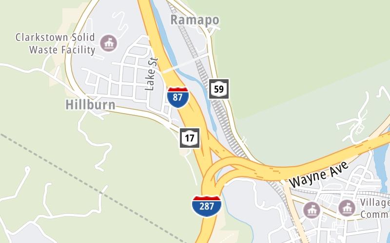
This location's approximate GPS Coordinates are 41.12133 x -74.16283.
Which directions can I travel from here?
From this junction, traffic can enter traveling both southbound and northbound. Traffic can also exit traveling both southbound and northbound.
On to NY Route 17 N / NY Route 59 / Sloatsburg / Suffern, about 1.2 miles away ►
◄ Back to Airmont Road / Airmont / Montebello, about 2.6 miles away.
▹ The New York State Thruway and the I 287 connect here.
Nearby gas and food are shown on the interactive map below.
Weather & Visibility

Mostly Cloudy
61°F / 16.1°C
Feels Like
73°F / 23°C

Visibility
21 Mi / 33.8 Km
3 Hr Precip
0 In / 0.0 Cm

-
SSE Wind
2.3 Mi / 3.7 Km
Gusts
5.1 Mi / 8.3 Km
See the full forecast for This Location or the New York City - Northern New Jersey area
Conditions and forecasts provided in partnership with AccuWeather.

Weather provided in partnership with AccuWeather.
Available Cameras

0.27 Mi
0.44 Mi
0.63 Mi
2.58 Mi


 Bayonne Bridge ▹
 Goethals Bridge ▹
 Holland Tunnel ▹
 Garden State Parkway ▹
 George Washington Bridge ▹
 Lincoln Tunnel ▹
 New Jersey Turnpike ▹
 Outerbridge Crossing ▹
 Bronx Whitestone Bridge ▹
 Hugh L Carey Tunnel ▹
 Cross Westchester Expressway ▹
 Robert F Kennedy Bridge ▹
 Queens Midtown Tunnel ▹
 New England Thruway ▹
 New York State Thruway ▹
 Throgs Neck Bridge ▹
 Henry Hudson Bridge ▹
 Atlantic Beach Bridge ▹
 Marine Parkway Bridge ▹
 Connecticut Turnpike ▹
 Bear Mountain Bridge ▹
 Massachusetts Turnpike ▹
 Thousand Islands Bridge ▹
 Niagara Thruway ▹
 Peace Bridge ▹
 Rainbow Bridge ▹

 Pennsylvania Turnpike ▹
 Milford Montague Toll Bridge ▹
 Delaware Water Gap Toll Bridge ▹
 Portland Columbia Toll Bridge ▹
 Easton Phillipsburg Toll Bridge ▹
 I78 Toll Bridge ▹


