This Location At A Glance
This toll point is located in Clarks Summit. Chinchilla is nearby. NOTE: Replaced by gantry A 123.
This location is in the Scranton - Wilkes Barre - Allentown area.
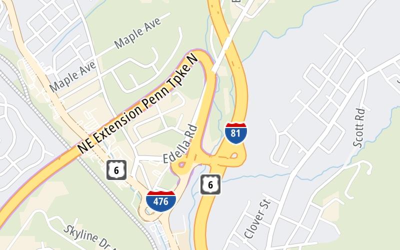
This location's approximate GPS Coordinates are 41.48460 x -75.68196.
This toll point is located on the Northeast Extension.
On to I-81 / US 11 / Clarks Summit, about 0.1 miles away ►
◄ Back to Keyser Avenue / Wyoming Valley, about 8.9 miles away.
Nearby gas and food are shown on the interactive map below.
Weather & Visibility

Thunderstorm
62°F / 16.6°C
Feels Like
59°F / 14.9°C

Visibility
10 Mi / 16.1 Km
3 Hr Precip
0.07 In / 0.2 Cm

-
SSW Wind
3.9 Mi / 6.3 Km
Gusts
9.6 Mi / 15.4 Km
See the full forecast for the Scranton - Wilkes Barre - Allentown area
Conditions and forecasts provided in partnership with AccuWeather.

Weather provided in partnership with AccuWeather.
Available Cameras

836 Ft
2.27 Mi
3.23 Mi


 PA Turnpike 66 ▹
 Beaver Valley Expressway ▹
 Mon Fayette Expressway ▹
 Pennsylvania Turnpike ▹
 Ohio Turnpike ▹
 PA Turnpike 576 ▹

 Delaware Memorial Bridge ▹
 Delaware Turnpike ▹
 Atlantic City Expressway ▹
 New Jersey Turnpike ▹
 Benjamin Franklin Bridge ▹
 Walt Whitman Bridge ▹
 Commodore Barry Bridge ▹
 Betsy Ross Bridge ▹
 Scudder Falls Toll Bridge ▹
 Trenton Morrisville Toll Bridge ▹
 Tacony Palmyra Bridge ▹
 Burlington Bristol Bridge ▹
 Milford Montague Toll Bridge ▹
 Delaware Water Gap Toll Bridge ▹
 Portland Columbia Toll Bridge ▹
 Easton Phillipsburg Toll Bridge ▹
 I78 Toll Bridge ▹
 Garden State Parkway ▹
 New Hope Lambertville Toll Bridge ▹


