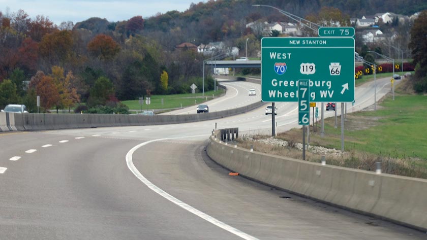
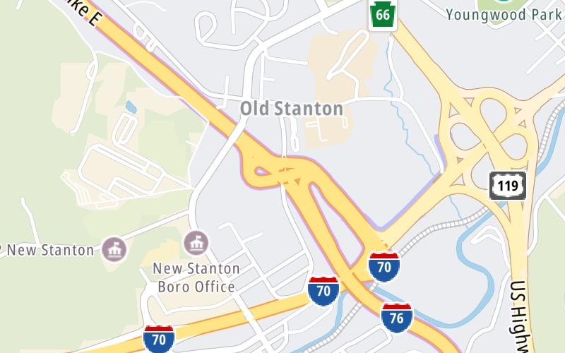
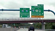
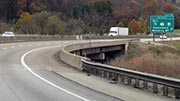
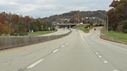
This is Exit 75 of the Pennsylvania Turnpike.
This junction is located in Mt Pleasant. New Stanton is nearby.
This location is in the Pittsburgh - Western Pennsylvania area.
This location's approximate GPS Coordinates are 40.22410 x -79.60640.
Which directions can I travel from here?
From this junction, traffic can enter traveling both westbound and eastbound. Traffic can also exit traveling both westbound and eastbound.
On to New Stanton Service Plaza, about 2.3 miles away ►
◄ Back to Toll Gantry T 075, about 0.5 miles away.
▹ The Pennsylvania Turnpike and the Pa Turnpike 66 connect here.
Which direction are tolls charged here?
The interactive map and lists on this page include key traveler services within two miles of this destination point.
You will find common services, including gas stations, truck stops, EV charging facilities, fast-food or family restaurants, and hotels. These are displayed on the interactive map as markers, which you can select for more information.
Current driving conditions and weather, along with a more complete list of key services, may be found below the map.
The interactive map shows dining and services near your chosen location: I-70 / PA 66 / US 119 and the Pennsylvania Turnpike. A detailed summary of food and services around here is shown after the map.
Pan and zoom the map as you desire, and select markers for information and other options, including online ordering, where available.
Mostly Sunny
64°F / 17.9°C
Feels Like:
65°F / 18.5°C
Visibility
12 Mi / 19.3 Km
3-Hour Precip:
0.03 In / 0.1 Cm
South Southwest
Winds (SSW)
4.9 MPH / 7.8 KPH
Gusts:
11.1 MPH / 17.8 KPH
▸ Get the full forecast for This Location | The Pittsburgh - Western Pennsylvania area
Closest Gas Stations
SHEETZ
205 North Center Avenue • 0.41 miles
Store/Fuel Brand: Sheetz
NEW STANTON EXXON
105 West Byers Avenue • 0.44 miles
Store/Fuel Brand: Exxon
SUNOCO
106 North Center Avenue • 0.48 miles
Store/Fuel Brand: Sunoco
GET GO CAFE & MARKET
119 Bair Boulevard • 0.53 miles
Store/Fuel Brand:
Closest EV Chargers
NEW STANTON, PA SUPERCHARGER
119 Bair Boulevard • 0.55 miles
CONNECTOR: Tesla
POWER: 250 KW @ 400 V
CURRENT: 625 Amp DC
Closest Fast Food
Fast food refers ONLY to quick-service and take-out diners. All restaurant types are shown on the map below.
BIG BLACK GRILL
103 East Byers Avenue • 0.38 miles
MCDONALD'S
9 West Byers Avenue • 0.49 miles
TACO BELL
105 Highland Avenue • 1,855 feet
WENDY'S
210 North Center Avenue • 1,962 feet
BURGER KING
408 South 3rd Street • 1.40 miles
DUNKIN'
407 South 3rd Street • 1.41 miles
LITTLE CAESARS
404 South 3rd Street • 1.49 miles
Select/Tap Vendors For Info
Vendors within about two miles of I-70 / PA 66 / US 119 and the Pennsylvania Turnpike are listed, sorted by distance, with the closest displayed on top. Select/tap the vendor name to show address, phone numbers and available URLs for gas stations, EV charging stations and fast-food dining. Links will open in a new window. Turnpikes.com is not responsible for third-party website content.
SHEETZ
• 0.41 miles
NEW STANTON EXXON
• 0.44 miles
SUNOCO
• 0.48 miles
GET GO CAFE & MARKET
• 0.53 miles
MARATHON
• 0.55 miles
UNITED PARCEL SERVICE
• 1,655 feet
BFS FOODS
• 1.42 miles
DAVE'S ENGINE & MACHINE
• 1.47 miles
NEW STANTON, PA SUPERCHARGER
• 0.55 miles
This list only includes quick-service and take-out restaurants. All nearby restaurants are shown on the map above.
BIG BLACK GRILL
• 0.38 miles
MCDONALD'S
• 0.49 miles
TACO BELL
• 1,855 feet
WENDY'S
• 1,962 feet
BURGER KING
• 1.40 miles
DUNKIN'
• 1.41 miles
LITTLE CAESARS
• 1.49 miles
Journey to key destinations around and adjacent to Pennsylvania!
Communities in this metro area include Pittsburgh, Cranberry Township, Beaver Valley, New Castle, Washington, Uniontown, Cheat Lake, West Virginia, Boardman, Ohio, and Youngstown, Ohio.
Individual toll maps for this region are listed below.
Communities in this metro area include Harrisburg, Mechanicsburg, Carlisle, Hershey, and York.
Individual toll maps for this region are listed below.
Communities in this metro area include Philadelphia, King Of Prussia, Valley Forge, West Chester, Bristol, Burlington, New Jersey, Morrisville, Trenton, New Jersey, Palmyra, New Jersey, Wilmington, Delaware, and Camden, New Jersey.
Individual toll maps for this region are listed below.
Roads Within Region
Communities in this metro area include Scranton, Wilkes Barre, Stroudsburg, Clarks Summit, and Knowlton Township, New Jersey.
Individual toll maps for this region are listed below.
Communities in this metro area include Camden, Burlington, Palmyra, Pennsauken, Cherry Hill, Gloucester City, Trenton, Wilmington, Delaware, Philadelphia, Pennsylvania, Tacony, Pennsylvania, and Bristol, Pennsylvania.
Individual toll maps for this region are listed below.
Roads Within Region
Communities in this metro area include Knowlton Township, Trenton, Phillipsburg, Easton, Pennsylvania, Lambertville, Ewing, Morrisville, Pennsylvania, and Stroudsburg, Pennsylvania.
Individual toll maps for this region are listed below.
Communities in this metro area include Cleveland, Akron, Boardman, Lorain, Aurora, Youngstown, New Castle, Pennsylvania, and Beaver Falls, Pennsylvania.
Individual toll maps for this region are listed below.