A Quick Look At The South Jersey - Philadelphia Area

The South Jersey - Philadelphia area includes the following cities: Camden, Burlington, Palmyra, Pennsauken, Cherry Hill, Gloucester City, Trenton, Wilmington, Delaware, Philadelphia, Pennsylvania, Tacony, Pennsylvania, and Bristol, Pennsylvania.
What You Will Find On The Regional Map
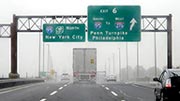
The interactive metro/regional map above shows exits and toll points for each toll road that is in, or crosses into, the South Jersey - Philadelphia area.
Markers can be selected for a map of that specific exit, toll gantry or other point of interest. Exit maps will show you nearby dining, gas, EV charging, hotels and other services.
The following (13) toll roads are in this area, cross through this area or connect with this region:
 ▸ Delaware Memorial Bridge
 ▸ Atlantic City Expressway
 ▸ Garden State Parkway
 ▸ New Jersey Turnpike
 ▸ Pennsylvania Turnpike
 ▸ Benjamin Franklin Bridge
 ▸ Walt Whitman Bridge
 ▸ Commodore Barry Bridge
 ▸ Betsy Ross Bridge
 ▸ Scudder Falls Toll Bridge
 ▸ Trenton Morrisville Toll Bridge
 ▸ Tacony Palmyra Bridge
 ▸ Burlington Bristol Bridge
Selecting a road will reveal a map of that toll road.


 Delaware River Joint Toll Bridge Commission
 Middle Thorofare Bridge ▹
 Grassy Sound Bridge ▹
 Ocean City Longport Bridge ▹
 Milford Montague Toll Bridge ▹
 Delaware Water Gap Toll Bridge ▹
 Portland Columbia Toll Bridge ▹
 Easton Phillipsburg Toll Bridge ▹
 I78 Toll Bridge ▹
 New Hope Lambertville Toll Bridge ▹
 Delaware Turnpike ▹
 State Route 1 ▹
 US 301 ▹
 John F Kennedy Memorial Highway ▹
 Bayonne Bridge ▹
 Goethals Bridge ▹
 Holland Tunnel ▹
 George Washington Bridge ▹
 Lincoln Tunnel ▹
 Outerbridge Crossing ▹
 Bronx Whitestone Bridge ▹
 Hugh L Carey Tunnel ▹
 Cross Westchester Expressway ▹
 Robert F Kennedy Bridge ▹
 Queens Midtown Tunnel ▹
 New England Thruway ▹
 New York State Thruway ▹
 Henry Hudson Bridge ▹
 Atlantic Beach Bridge ▹
 Marine Parkway Bridge ▹
 Connecticut Turnpike ▹


