Uniontown Traffic And Weather

Static map of Mon Fayette Expressway at Main Street / US 40

Right Now At Main Street / US 40 and The Mon Fayette Expressway

Current Weather And Visibility

1:20 am Local Time

  • 01 6 08
  • Cloudy

    64°F / 17.9°C

    Feels Like:

    63°F / 17.5°C

  • Visibility

    11 Mi / 17.7 Km

    3-Hour Precip:

    0 In / 0.0 Cm

  • North Northeast
    Winds (NNE)

    5.9 MPH / 9.6 KPH

    Gusts:

    15.7 MPH / 25.2 KPH

Conditions and forecasts provided in partnership with AccuWeather.

AccuWeather logo

Weather provided in partnership with AccuWeather.

AccuWeather logo

Forecast weather and driving conditions follow the jump. These include an hour-by-hour forecast for the next 12-hours, a three-day forecast and an extended forecast, for extended travel planning.

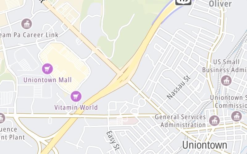
An area traffic map, with available traffic cameras, shows driving conditions, from current traffic to mother nature's influence on the road. These follow the short-range forecasts below.

Driving Forecast Traffic Map

Advertising
Advertising

Driving Forecast For Uniontown, At Main Street / US 40

Next 12 Hours

1:20 am Local Time

Conditions and forecasts provided in partnership with AccuWeather.

AccuWeather logo

Weather provided in partnership with AccuWeather.

AccuWeather logo

Available Cameras

No camera feed …

There is no currently-available traffic camera feed for this location.

Next Three (3) Days

Thursday July 31

Thursday forecast: More clouds than sun; humid with a couple of showers and a heavy thunderstorm; thunderstorms can bring flash flooding and localized damaging wind gusts

Mostly Cloudy W/ T-storms

97% Chance Rain

83° F/28.3° C

W Wind

5 to 14 Mi/

7 to 22 Km

Sunrise

6:16 AM

Thursday night: More clouds than sun; humid with a couple of showers and a heavy thunderstorm; thunderstorms can bring flash flooding and localized damaging wind gusts

Mostly Cloudy

25% Chance Rain

62° F/16.7° C

NNE Wind

12 to 29 Mi/

19 to 46 Km

Sunset

8:34 PM

Friday August 1

Friday forecast: Clouds giving way to some sun and not as warm with lower humidity

Intermittent Clouds

9% Chance Rain

75° F/23.9° C

NNE Wind

6 to 17 Mi/

9 to 28 Km

Sunrise

6:17 AM

Friday night: Clouds giving way to some sun and not as warm with lower humidity

Mostly Clear

1% Chance Rain

55° F/12.8° C

NE Wind

5 to 13 Mi/

7 to 20 Km

Sunset

8:33 PM

Saturday August 2

Saturday forecast: Mostly sunny with low humidity; a beautiful start to the weekend

Mostly Sunny

0% Chance Rain

78° F/25.6° C

NE Wind

6 to 15 Mi/

9 to 24 Km

Sunrise

6:18 AM

Saturday night: Mostly sunny with low humidity; a beautiful start to the weekend

Clear

0% Chance Rain

55° F/12.8° C

ESE Wind

5 to 12 Mi/

7 to 19 Km

Sunset

8:32 PM

Advertising
Advertising

Area Traffic Map

This junction is located in Uniontown, at GPS 39.90643 x -79.73956. This location is in the Pittsburgh - Western Pennsylvania area.

You can pan and zoom the interactive map. Select cameras to see the on-road traffic feeds, and pick exits or other markers for conditions at those locations.

Advertising
Advertising

Extended Forecast For Uniontown, At Main Street / US 40

Ten (10) Day Travel Planner

Go Online Before You Go On The Road!®

Conditions and forecasts provided in partnership with AccuWeather.

AccuWeather logo

Weather provided in partnership with AccuWeather.

AccuWeather logo
Advertising
Advertising

EXPLORE PENNSYLVANIA

Journey to key destinations around and adjacent to Pennsylvania!

Map Of This Region ▹

Communities in this metro area include Pittsburgh, Cranberry Township, Beaver Valley, New Castle, Washington, Uniontown, Cheat Lake, West Virginia, Boardman, Ohio, and Youngstown, Ohio.

Individual toll maps for this region are listed below.

Map Of This Region ▹

Communities in this metro area include Harrisburg, Mechanicsburg, Carlisle, Hershey, and York.

Individual toll maps for this region are listed below.

Map Of This Region ▹

Communities in this metro area include Philadelphia, King Of Prussia, Valley Forge, West Chester, Bristol, Burlington, New Jersey, Morrisville, Trenton, New Jersey, Palmyra, New Jersey, Wilmington, Delaware, and Camden, New Jersey.

Individual toll maps for this region are listed below.

Map Of This Region ▹

Communities in this metro area include Scranton, Wilkes Barre, Stroudsburg, Clarks Summit, and Knowlton Township, New Jersey.

Individual toll maps for this region are listed below.

Map Of This Region ▹

Communities in this metro area include Camden, Burlington, Palmyra, Pennsauken, Cherry Hill, Gloucester City, Trenton, Wilmington, Delaware, Philadelphia, Pennsylvania, Tacony, Pennsylvania, and Bristol, Pennsylvania.

Individual toll maps for this region are listed below.

Map Of This Region ▹

Communities in this metro area include Knowlton Township, Trenton, Phillipsburg, Easton, Pennsylvania, Lambertville, Ewing, Morrisville, Pennsylvania, and Stroudsburg, Pennsylvania.

Individual toll maps for this region are listed below.

Map Of This Region ▹

Communities in this metro area include Cleveland, Akron, Boardman, Lorain, Aurora, Youngstown, New Castle, Pennsylvania, and Beaver Falls, Pennsylvania.

Individual toll maps for this region are listed below.

Advertising
Advertising
Turnpikes.com is proud to partner with the following: