This Location At A Glance
This is Exit 12A of the Beaver Valley Expressway.
This junction is located in Oakwood. New Castle is nearby. NOTE: EB Off Only / All others use 12/12B.
This location is in the Pittsburgh - Western Pennsylvania area; it also overlaps with the Cleveland - Akron - Youngstown area.
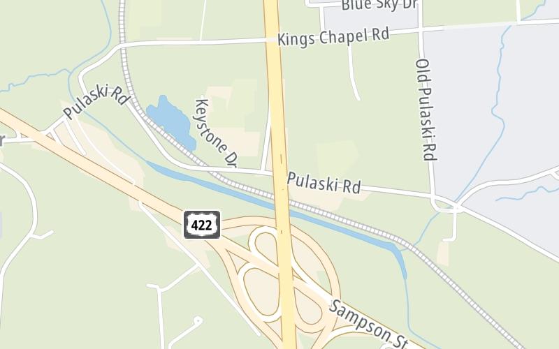
This location's approximate GPS Coordinates are 41.03366 x -80.39051.
Which directions can I travel from here?
From this junction, traffic can only exit going eastbound.
On to US 422 Bus / Sampson St, about 0.4 miles away ►
◄ Back to Mitchell Road, about 2.3 miles away.
Nearby gas and food are shown on the interactive map below.
Weather & Visibility

Mostly Cloudy
71°F / 21.5°C
Feels Like
76°F / 24.5°C

Visibility
11 Mi / 17.7 Km
3 Hr Precip
0.06 In / 0.2 Cm

-
SW Wind
7.5 Mi / 12.1 Km
Gusts
16.4 Mi / 26.3 Km
See the full forecast for This Location or the Pittsburgh - Western Pennsylvania area
Conditions and forecasts provided in partnership with AccuWeather.

Weather provided in partnership with AccuWeather.
Available Cameras

1.63 Mi


 PA Turnpike 66 ▹
 Beaver Valley Expressway ▹
 Mon Fayette Expressway ▹
 Pennsylvania Turnpike ▹
 Ohio Turnpike ▹
 PA Turnpike 576 ▹

 Delaware Memorial Bridge ▹
 Delaware Turnpike ▹
 Atlantic City Expressway ▹
 New Jersey Turnpike ▹
 Benjamin Franklin Bridge ▹
 Walt Whitman Bridge ▹
 Commodore Barry Bridge ▹
 Betsy Ross Bridge ▹
 Scudder Falls Toll Bridge ▹
 Trenton Morrisville Toll Bridge ▹
 Tacony Palmyra Bridge ▹
 Burlington Bristol Bridge ▹
 Milford Montague Toll Bridge ▹
 Delaware Water Gap Toll Bridge ▹
 Portland Columbia Toll Bridge ▹
 Easton Phillipsburg Toll Bridge ▹
 I78 Toll Bridge ▹
 Garden State Parkway ▹
 New Hope Lambertville Toll Bridge ▹


