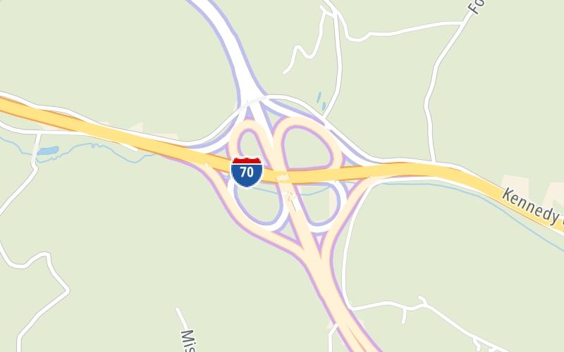
Share

Mon Fayette Expressway At I–70

Advertising
Advertising

About This Location

I–70
Photo by Turnpikes.com

At A Glance

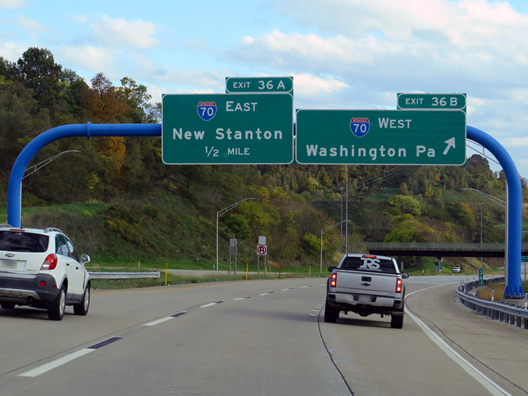
This is Exit 36A/B of the Mon Fayette Expressway.

This junction is located in Fallowfield Township.

This location is in the Pittsburgh - Western Pennsylvania area.

Interactive Map Below

This location's approximate GPS Coordinates are 40.10975 x -79.92023.

Which directions can I travel from here?

From this junction, traffic can enter traveling both southbound and northbound. Traffic can also exit traveling both southbound and northbound.

On to Coyle Curtin Rd / Charleroi / Donora, about 3.7 miles away ►

◄ Back to Elco Hill Road, about 2.2 miles away.

Which direction are tolls charged here?

Tolls are not charged or collected at this junction.

View Map Travel Conditions

Closest Food, Gas, EV And Other Services Near I–70

Use the map below for all services within about a two (2) mile radius.

Fuel, EV and convenience store header

Gas & EV Charging

Closest Gas Stations

View Map

No gas or other fuel stations nearby.

Closest EV Chargers

View Map

No EV charging stations nearby.

Coffee, snacks and dining header

Fast Food & Beverage

Closest Fast Food

Fast food refers ONLY to quick-service and take-out diners. All restaurant types are shown on the map below.

View Map

No fast-food dining nearby.

Advertising
Advertising

Interactive POI Map

The interactive map and lists on this page include key traveler services in a two-mile radius, including gas stations, truck stops, EV charging facilities, fast-food or family restaurants, and hotels.

Current driving conditions and weather, may be found below.

Advertising
Advertising

Travel Conditions At I–70

Current Weather And Visibility

  • 10 7 12
  • Mostly Cloudy

    27°F / -2.6°C

    Feels Like:

    25°F / -3.6°C

  • Visibility

    12 Mi / 19.3 Km

    3-Hour Precip:

    0 In / 0.0 Cm

  • West
    Winds (W)

    4.9 MPH / 7.8 KPH

    Gusts:

    11.4 MPH / 18.4 KPH

▸ Get the full forecast for This Location | The Pittsburgh - Western Pennsylvania area

Available Cameras

I-70 @ EXIT 37 (PA TURNPIKE 43)

Camera direction: NORTH. Pittsburgh 15022.
Source: PennDOT.

Camera direction: NORTH. Pittsburgh 15022.<br />Source: PennDOT -

210 Ft

Camera direction: NORTH. Pittsburgh 15012.<br />Source: PennDOT -

2.75 Mi

Advertising
Advertising

Pictures At I–70

Drivers approach the exit for Interstate 70 as they make their way southbound on Turnpike 43 (the Mon-Fayette Expressway). Westbound traffic, to West Virginia and Ohio, uses Exit 36B, which is the first ramp for southbound drivers. Exit 36A, which will take drivers to I-70 eastbound, comes second on the southbound leg of the Mon-Fayette Expressway. Photo taken 10-17-2022

Photo taken 10-17-2022
Advertising
Advertising

Discover Pennsylvania Attractions

Hotels and destinations header

Hotels & Airports

Destination Travel

Advertising
Advertising

EXPLORE PENNSYLVANIA

Journey to key destinations around and adjacent to Pennsylvania!

Map Of This Region ▹

Communities in this metro area include Pittsburgh, Cranberry Township, Beaver Valley, New Castle, Washington, Uniontown, Cheat Lake, West Virginia, Boardman, Ohio, and Youngstown, Ohio.

Individual toll maps for this region are listed below.

Map Of This Region ▹

Communities in this metro area include Harrisburg, Mechanicsburg, Carlisle, Hershey, and York.

Individual toll maps for this region are listed below.

Map Of This Region ▹

Communities in this metro area include Philadelphia, King Of Prussia, Valley Forge, West Chester, Bristol, Burlington, New Jersey, Morrisville, Trenton, New Jersey, Palmyra, New Jersey, Wilmington, Delaware, and Camden, New Jersey.

Individual toll maps for this region are listed below.

Map Of This Region ▹

Communities in this metro area include Scranton, Wilkes Barre, Stroudsburg, Clarks Summit, and Knowlton Township, New Jersey.

Individual toll maps for this region are listed below.

Map Of This Region ▹

Communities in this metro area include Camden, Burlington, Palmyra, Pennsauken, Cherry Hill, Gloucester City, Trenton, Wilmington, Delaware, Philadelphia, Pennsylvania, Tacony, Pennsylvania, and Bristol, Pennsylvania.

Individual toll maps for this region are listed below.

Map Of This Region ▹

Communities in this metro area include Knowlton Township, Trenton, Phillipsburg, Easton, Pennsylvania, Lambertville, Ewing, Morrisville, Pennsylvania, and Stroudsburg, Pennsylvania.

Individual toll maps for this region are listed below.

Map Of This Region ▹

Communities in this metro area include Cleveland, Akron, Boardman, Lorain, Aurora, Youngstown, New Castle, Pennsylvania, and Beaver Falls, Pennsylvania.

Individual toll maps for this region are listed below.

Static map of Mon Fayette Expressway at I–70

Static map. Interactive map is above.

Advertising
Advertising
Turnpikes.com is proud to partner with the following: