Share

West Virginia Turnpike At Tamarack / Van Kirk Drive

Advertising
Advertising

About This Location

Tamarack / Van Kirk Drive
Photo by Turnpikes.com

At A Glance

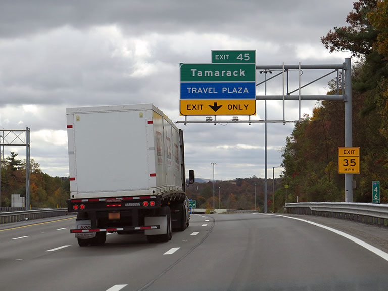
This is Exit 45 of the West Virginia Turnpike.

This junction is located in Beckley. NOTE: Use this exit for Beckley Travel Plaza.

This location is in the Beckley - Princeton area.

Interactive Map Below

This location's approximate GPS Coordinates are 37.81022 x -81.21234.

Which directions can I travel from here?

From this junction, traffic can enter traveling both southbound and northbound. Traffic can also exit traveling both southbound and northbound.

On to Beckley Travel Plaza, about 0.0 miles away ►

◄ Back to Harper Road/WV 3, about 1.4 miles away.

Which direction are tolls charged here?

Tolls are not charged or collected at this junction.

View Map Travel Conditions

Closest Food, Gas, EV And Other Services Near Tamarack / Van Kirk Drive

Use the map below for all services within about a two (2) mile radius.

Fuel, EV and convenience store header

Gas & EV Charging

Closest Gas Stations

Exxon

EXXON

500 Vankirk Dr • 0.56 miles

Store/Fuel Brand: Exxon

Marathon

MARATHON

2046 Harper Road • 1.09 miles

Store/Fuel Brand: Marathon

Shell

SHELL

2004 Harper Road • 1.27 miles

Store/Fuel Brand: Shell

Exxon

EXXON

2005 Harper Road • 1.30 miles

Store/Fuel Brand: Exxon

View Map

Closest EV Chargers

BECKLEY TRAVEL PLAZA

500 Vankirk Drive • 0.52 miles

PIKEVIEW MANOR

315 Pikeview Drive • 0.66 miles

BEST WESTERN PLUS

125 Hylton Lane • 1.22 miles

LEWIS NISSAN

1 Plaza Center • 1.52 miles

View Map

Coffee, snacks and dining header

Fast Food & Beverage

Closest Fast Food

Fast food refers ONLY to quick-service and take-out diners. All restaurant types are shown on the map below.

Popeyes

POPEYES

500 Vankirk Drive • 0.55 miles

Subway

SUBWAY

2046 Harper Road • 1.08 miles

Dunkin'

DUNKIN'

2046 Harper Road • 1.08 miles

Wendy's

WENDY'S HARPER PARK DR, EXIT 44 IN BECKLEY, WV

120 Harper Park Drive • 1.15 miles

Hardee's

HARDEE'S

2004 Harper Road • 1.27 miles

McDonald's

MCDONALD'S

101 Hylton Lane • 1.28 miles

Chick-fil-A

CHICK-FIL-A

100 Hylton Lane • 1.29 miles

Dunkin'

DUNKIN'

2005 Harper Road • 1.30 miles

View Map

Advertising
Advertising

Interactive POI Map

The interactive map and lists on this page include key traveler services in a two-mile radius, including gas stations, truck stops, EV charging facilities, fast-food or family restaurants, and hotels.

Current driving conditions and weather, may be found below.

Advertising
Advertising

Travel Conditions At Tamarack / Van Kirk Drive

Current Weather And Visibility

  • 12 7 12
  • Cloudy

    16°F / -8.9°C

    Feels Like:

    -3°F / -19.3°C

  • Visibility

    3 Mi / 4.8 Km

    3-Hour Precip:

    0.05 In / 0.1 Cm

  • Northwest
    Winds (NW)

    12.7 MPH / 20.4 KPH

    Gusts:

    21.9 MPH / 35.2 KPH

▸ Get the full forecast for This Location | The Beckley - Princeton area

Available Cameras

No camera feed …

There is no currently-available traffic camera feed for this location.

Advertising
Advertising

Pictures At Tamarack / Van Kirk Drive

The southbound exit for Tamarack and Van Kirk Drive is just over a rise and around a left-hand curve on the West Virginia Turnpike. Crucially, it is also the exit drivers use to get to the Beckley Travel Plaza, which shares the ramp. Photo taken 10-19-2022

Photo taken 10-19-2022
Advertising
Advertising

Discover West Virginia Attractions

Hotels and destinations header

Hotels & Airports

Destination Travel

Advertising
Advertising

EXPLORE WEST VIRGINIA

Journey to key destinations around and adjacent to West Virginia!

Map Of This Region ▹

Communities in this metro area include Charleston, Malden, South Ruffner, and Snow Hill.

Individual toll maps for this region are listed below.

Map Of This Region ▹

Communities in this metro area include Beckley, Beaver, Mac Arthur, Daniels, and Shady Spring.

Individual toll maps for this region are listed below.

Map Of This Region ▹

Communities in this metro area include Parkersburg, North Hills, Vienna, and Belpre, Ohio.

Individual toll maps for this region are listed below.

Map Of This Region ▹

Communities in this metro area include Pittsburgh, Cranberry Township, Beaver Valley, New Castle, Washington, Uniontown, Cheat Lake, West Virginia, Boardman, Ohio, and Youngstown, Ohio.

Individual toll maps for this region are listed below.

Static map of West Virginia Turnpike at Tamarack / Van Kirk Drive

Static map. Interactive map is above.

Advertising
Advertising
Turnpikes.com is proud to partner with the following: