West Virginia Turnpike At Leon Sullivan Way / Brooks Street

Leon Sullivan Way / Brooks Street

At A Glance

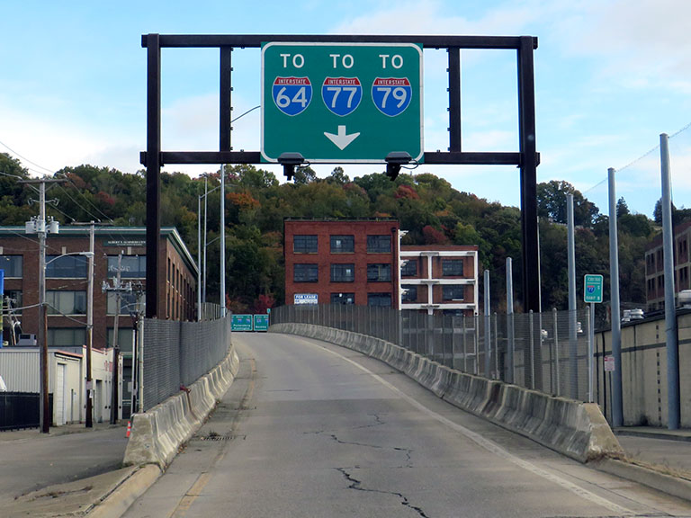
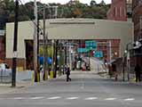
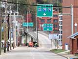
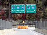
This is Exit 100 of the West Virginia Turnpike.

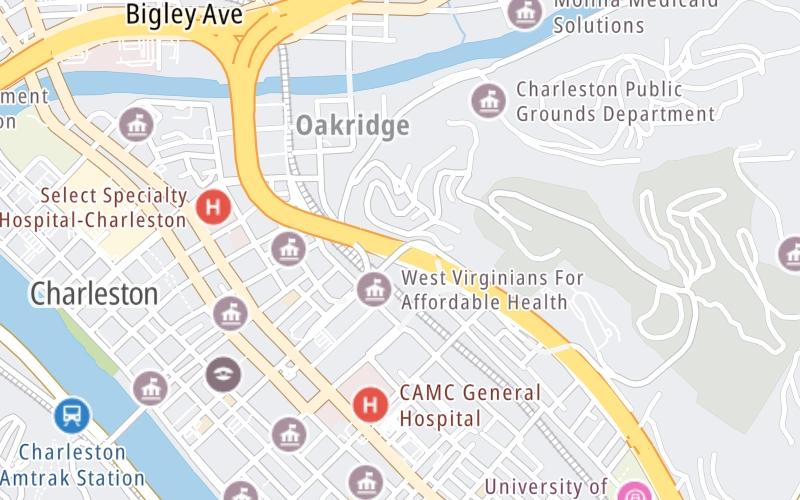
This junction is located in Charleston. Enter turnpike from Brooks Street.

This location is in the Charleston - State Capital area.

▾ Interactive Map Below ▾

This location's approximate GPS Coordinates are 38.35262 x -81.62523.

Which directions can I travel from here?

From this junction, traffic can enter traveling both southbound and northbound. Traffic can also exit traveling both southbound and northbound.

On to I77 North / I64 West / to I79, about 0.6 miles away ►

◄ Back to Greenbrier Street/WV 114 / State Capitol, about 1.0 mile away.

Which direction are tolls charged here?

Tolls are not charged or collected at this junction.

▾ Travel Conditions ▾

Above: Photo by Turnpikes.com

Using The POI Map

The interactive map and lists on this page include key traveler services within two miles of this destination point.

You will find common services, including gas stations, truck stops, EV charging facilities, fast-food or family restaurants, and hotels. These are displayed on the interactive map as markers, which you can select for more information.

Current driving conditions and weather, along with a more complete list of key services, may be found below the map.

View Map ▾Weather ▾

Static map of West Virginia Turnpike at Leon Sullivan Way / Brooks Street
Static map. Interactive map is below.

The interactive map shows dining and services near your chosen location: Leon Sullivan Way / Brooks Street and the West Virginia Turnpike. A detailed summary of food and services around here is shown after the map.

View Map ▾

Advertising
Advertising

Interactive Exit Map With Nearby Gas, Food And Lodging

Area Map & Services Up To Two (2) Miles

Pan and zoom the map as you desire, and select markers for information and other options, including online ordering, where available.

Advertising
Advertising

Travel Conditions At Leon Sullivan Way / Brooks Street

Current Weather And Visibility

  • 13 7 02
  • Mostly Sunny

    36°F / 2.5°C

    Feels Like:

    42°F / 5.3°C

  • Visibility

    12 Mi / 19.3 Km

    3-Hour Precip:

    0 In / 0.0 Cm

  • West
    Winds (W)

    1.9 MPH / 3.1 KPH

    Gusts:

    6.5 MPH / 10.5 KPH

▸ Get the full forecast for This Location | The Charleston - State Capital area

Available Cameras

No camera feed …

There is no currently-available traffic camera feed for this location.

Travel Pictures

Pictures Around Leon Sullivan Way / Brooks Street

About this photo:
The entrance ramp for Exit 100 is on Brooks Street, about a block away from Leon Sullivan Way, which is the one-way street used for the exits from the West Virginia Turnpike. As seen in this photo, the onramp for both northbound and southbound is a single, alley-like channel that splits from Brooks. Photo taken October 19, 2022.

Photo taken 10-19-2022

More Pictures Near Leon Sullivan Way / Brooks Street

Photo taken 10-19-2022
Advertising
Advertising

Food, Gas, EV And Other Services Near Leon Sullivan Way / Brooks Street

Fuel, EV and convenience store header

Gas & EV Charging

Closest Gas Stations

BIGLEY EXPRESS

10 Spring Street • 0.47 miles

Store/Fuel Brand:

CHARNOCK & CHARNOCK

179 Summers Street • 0.51 miles

Store/Fuel Brand:

CIPRIANI & WERNER

500 Lee Street East • 0.52 miles

Store/Fuel Brand:

AMOCO

1503 Washington Street East • 0.65 miles

Store/Fuel Brand: Amoco

View Map ▴Full List ▾

Closest EV Chargers

901 LEE STREET PARKING

901 Lee Street East • 0.47 miles

CONNECTOR: IEC62196Type1
POWER: 2 KW @ 270 V
CURRENT: 10 Amp AC1

MOSES CADILLAC GMC TRUCK - CHARLESTON, WV

1406 Washington Street East • 0.51 miles

CONNECTOR: IEC62196Type1CCS
POWER: 50 KW @ 400 V
CURRENT: 125 Amp DC

EV CONNECT

1406 Washington Street East • 0.53 miles

CONNECTOR: IEC62196Type1CCS
POWER: 50 KW @ 400 V
CURRENT: 125 Amp DC

CHARLESTON, WV SUPERCHARGER

100 Kanawha Boulevard East • 0.97 miles

CONNECTOR: Tesla
POWER: 150 KW @ 400 V
CURRENT: 375 Amp DC

View Map ▴Full List ▾

Coffee, snacks and dining header

Fast Food & Beverage

Closest Fast Food

Fast food refers ONLY to quick-service and take-out diners. All restaurant types are shown on the map below.

TAYLOR BOOKS CAFE

226 Capitol Street • 0.51 miles

HARDEE'S

1506 Bigley Avenue • 0.60 miles

GINO'S PIZZA & SPAGHETTI HOUSE

1500 Washington Street East • 0.63 miles

JIMMY JOHN'S

32 Capitol Street • 0.63 miles

DANCING DOG ICE CREAM CAFE

Court Street • 0.64 miles

TUDOR'S BISCUIT WORLD

1506 Washington Street East • 0.65 miles

HUNT BROTHERS PIZZA

1503 Washington Street East • 0.65 miles

CHARLEYS PHILLY STEAKS

3015 Charleston Town Center • 0.67 miles

View Map ▴Full List ▾

Hotels and destinations header

Hotels & Airports

Destination Travel

Discover West Virginia Attractions

Advertising
Advertising

Services Within Two Miles

Lists Include Fuel, EV Charging and Fast Food

Select/Tap Vendors For Info

Open the columns below to show address, phone numbers and available URLs for gas stations, EV charging stations and fast-food dining within about two miles of Leon Sullivan Way / Brooks Street and the West Virginia Turnpike.

▾ Open For Full Lists ▾

EXPLORE WEST VIRGINIA

Journey to key destinations around and adjacent to West Virginia!

Map Of This Region ▹

Communities in this metro area include Charleston, Malden, South Ruffner, and Snow Hill.

Individual toll maps for this region are listed below.

Map Of This Region ▹

Communities in this metro area include Beckley, Beaver, Mac Arthur, Daniels, and Shady Spring.

Individual toll maps for this region are listed below.

Map Of This Region ▹

Communities in this metro area include Parkersburg, North Hills, Vienna, and Belpre, Ohio.

Individual toll maps for this region are listed below.

Map Of This Region ▹

Communities in this metro area include Pittsburgh, Cranberry Township, Beaver Valley, New Castle, Washington, Uniontown, Cheat Lake, West Virginia, Boardman, Ohio, and Youngstown, Ohio.

Individual toll maps for this region are listed below.

Advertising
Advertising
Turnpikes.com is proud to partner with the following: