Downtown Tunnel Map

Advertising
Advertising
Static map a segment of the Downtown Tunnel

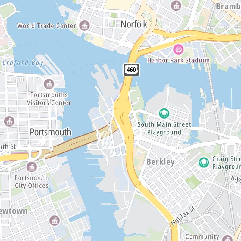
A Quick Look At The Downtown Tunnel

This tunnel toll road serves Norfolk and Portsmouth.

The fixed map seen here presents a quick view of The Downtown Tunnel and surrounding area. The fully-interactive map of The Downtown Tunnel below includes linked markers. You may resize and reposition the interactive map to orient the road in relation to other landmarks.

There is also a complete list of exits below the interactive map.

View Map ▾Exit / POI List ▾

What Does It Cost To Use The Downtown Tunnel?

Tolls For Cars, SUVs, Pickups, etc.

▹ Toll as of January 1, 2024.

The total toll for using the Downtown Tunnel is $3.06, if you are using a compatible transponder, RFID sticker or other pass.

Transponders You Can Use

For drivers paying with a transponder, the following passes will work on the Downtown Tunnel

  • e-zpass
  • epass xtra
  • i-pass
  • quick pass
  • riverlink
  • sunpass pro
  • uni

Learn about transponders and accounts in Virginia.

Without a compatible pass or transponder, the toll will be $7.57.

View Map ▾All Tolls / Calculator ▸

Our new toll and trip calculator is being constructed. For most roads, you can still use the legacy calculator for current, accurate tolls.

Advertising
Advertising

Using The Interactive Toll Map

You may pan and zoom the interactive map. There are markers you may select for a separate map of that point of interest or location, which will show any nearby dining, gas, EV charging, hotels and other services.

A complete list of exits and other points-of-interest may be found below the map. Exits and gantries will display the toll agency responsible for tolls on that portion of the roadway.

View Map ▾Exit / POI List ▾

Advertising
Advertising

The Downtown Tunnel Toll Map

This map of the Downtown Tunnel displays markers for exits and tolling points, which you can select to get a close-up map of that point of interest or location.

The points-of-interest shown on this map are also listed below, ordered from west to east.

Discover Virginia Attractions

Advertising
Advertising

List Of Exits / Points Of Interest For The Downtown Tunnel

Select an exit or other location to get a separate map, including locations of available gas, EV charging, fast-food and other dining options, plus current weather and driving conditions.

West Side / Norfolk Naval Shipyard

West Side / Norfolk Naval Shipyard — Portsmouth

View Map & Info

▸ GPS 36.830864000 X -76.302657000
NOTES:

Elizabeth River Tunnels Elizabeth River Crossings manages this segment.

East Side / I–464 / Downtown Norfolk

East Side / I–464 / Downtown Norfolk — Norfolk

View Map & Info

▸ GPS 36.835133000 X -76.287766000
NOTES:

Elizabeth River Tunnels Elizabeth River Crossings manages this segment.

Advertising
Advertising

EXPLORE VIRGINIA

Journey to key destinations around and adjacent to Virginia!

Map Of This Region ▹

Communities in this metro area include Richmond, Meadowbrook, Manchester, and Brandermill.

Individual toll maps for this region are listed below.

Map Of This Region ▹

Communities in this metro area include Norfolk, Chesapeake, Virginia Beach, Newport News, Portsmouth, Suffolk, and Moyock, North Carolina.

Individual toll maps for this region are listed below.

Map Of This Region ▹

Communities in this metro area include Washington, Dc, Fairfax County, Virginia, Loundoun County, Virginia, Montgomery County, Maryland, and Prince George's County, Maryland.

Individual toll maps for this region are listed below.

Map Of This Region ▹

Communities in this metro area include Pittsburgh, Cranberry Township, Beaver Valley, New Castle, Washington, Uniontown, Cheat Lake, West Virginia, Boardman, Ohio, and Youngstown, Ohio.

Individual toll maps for this region are listed below.

Map Of This Region ▹

Communities in this metro area include Charleston, Malden, South Ruffner, and Snow Hill.

Individual toll maps for this region are listed below.

Map Of This Region ▹

Communities in this metro area include Beckley, Beaver, Mac Arthur, Daniels, and Shady Spring.

Individual toll maps for this region are listed below.

Advertising
Advertising
Turnpikes.com is proud to partner with the following: