Dallas North Tollway Map

Advertising
Advertising
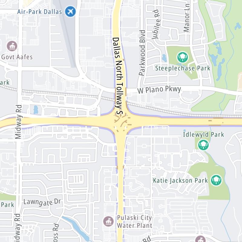
Static map a segment of the Dallas North Tollway

A Quick Look At The Dallas North Tollway

This local toll road serves several key cities, including Addison, Dallas, Plano, and Frisco.

The static map seen here shows a segment of The Dallas North Tollway at President George Bush Turnpike. The entirety of The Dallas North Tollway can be seen in the fully-interactive map below, which includes linked markers. You may resize and reposition the interactive map to orient the road in relation to other landmarks.

There is also a complete list of exits below the interactive map.

View Map ▾Exit / POI List ▾

What Does It Cost To Use The Dallas North Tollway?

Tolls For Cars, SUVs, Pickups, etc.

▹ Toll as of July 1, 2023.

The total toll for using the Dallas North Tollway is $7.04, if you are using a compatible transponder, RFID sticker or other pass.

NOTE: The rates shown are the maximum toll incurred. Your trip may have a lower rate.

Transponders You Can Use

For drivers paying with a transponder, the following passes will work on the Dallas North Tollway

  • tolltag
  • eztag
  • txtag
  • pikepass
  • k-tag
  • sunpass pro
  • expresstoll

Learn about transponders and accounts in Texas.

Without a compatible pass or transponder, the toll will be $14.08.

View Map ▾All Tolls / Calculator ▸

Our new toll and trip calculator is being constructed. For most roads, you can still use the legacy calculator for current, accurate tolls.

Advertising
Advertising

Using The Interactive Toll Map

You may pan and zoom the interactive map. There are markers you may select for a separate map of that point of interest or location, which will show any nearby dining, gas, EV charging, hotels and other services.

A complete list of exits and other points-of-interest may be found below the map. Exits and gantries will display the toll agency responsible for tolls on that portion of the roadway.

View Map ▾Exit / POI List ▾

Advertising
Advertising

The Dallas North Tollway Toll Map

This map of the Dallas North Tollway displays markers for exits and tolling points, which you can select to get a close-up map of that point of interest or location.

The points-of-interest shown on this map are also listed below, ordered from south to north.

Discover Texas Attractions

Advertising
Advertising

List Of Exits / Points Of Interest For The Dallas North Tollway

Select an exit or other location to get a separate map, including locations of available gas, EV charging, fast-food and other dining options, plus current weather and driving conditions.

Hines Blvd / McKinnon St

Hines Blvd / McKinnon St — Dallas

View Map & Info

▸ GPS 32.797227000 X -96.810580000
NOTES: SB Off/NB On

NTTA North Texas Tollway Authority manages this segment.

I–35E/Stemmons Freeway

I–35E/Stemmons Freeway — Dallas

View Map & Info

▸ GPS 32.800806000 X -96.816302000
NOTES: SB Off/NB On

NTTA North Texas Tollway Authority manages this segment.

Oak Lawn Avenue

Oak Lawn Avenue — Dallas

View Map & Info

▸ GPS 32.802307000 X -96.816464000
NOTES: SB Off/NB On

NTTA North Texas Tollway Authority manages this segment.

Wycliff Avenue

Wycliff Avenue — Dallas

View Map & Info

▸ GPS 32.811333000 X -96.817965000
NOTES: SB Off/NB On

NTTA North Texas Tollway Authority manages this segment.

Wycliff Main Lane Gantry

Wycliff Main Lane Gantry — Dallas

View Map & Info

▸ GPS 32.813963000 X -96.817637000
NOTES:

NTTA North Texas Tollway Authority manages this segment.

Lemmon Avenue

Lemmon Avenue — Dallas

View Map & Info

▸ GPS 32.821469000 X -96.816776000
NOTES: SB On/NB Off

NTTA North Texas Tollway Authority manages this segment.

Mockingbird Lane

Mockingbird Lane — Dallas

View Map & Info

▸ GPS 32.836623000 X -96.814888000
NOTES:

NTTA North Texas Tollway Authority manages this segment.

Lovers Lane

Lovers Lane — Dallas

View Map & Info

▸ GPS 32.851179000 X -96.813153000
NOTES: SB On/NB Off

NTTA North Texas Tollway Authority manages this segment.

Northwest Highway/SH 12

Northwest Highway/SH 12 — Dallas

View Map & Info

▸ GPS 32.865551000 X -96.811360000
NOTES:

NTTA North Texas Tollway Authority manages this segment.

Walnut Hill Lane

Walnut Hill Lane — Dallas

View Map & Info

▸ GPS 32.880102000 X -96.809631000
NOTES: SB On/NB Off

NTTA North Texas Tollway Authority manages this segment.

Royal Lane

Royal Lane — Dallas

View Map & Info

▸ GPS 32.894839000 X -96.809225000
NOTES:

NTTA North Texas Tollway Authority manages this segment.

Forest Lane

Forest Lane — Dallas

View Map & Info

▸ GPS 32.909504000 X -96.814469000
NOTES: SB On/NB Off

NTTA North Texas Tollway Authority manages this segment.

Harvest Hill Road

Harvest Hill Road — Dallas

View Map & Info

▸ GPS 32.921509000 X -96.818738000
NOTES: SB On/NB Off

NTTA North Texas Tollway Authority manages this segment.

I–635/Lyndon B Johnson Fwy

I–635/Lyndon B Johnson Fwy — Dallas

View Map & Info

▸ GPS 32.925972000 X -96.820587000
NOTES:

NTTA North Texas Tollway Authority manages this segment.

Alpha Road

Alpha Road — Dallas

View Map & Info

▸ GPS 32.932889000 X -96.821956000
NOTES: SB Off/NB On

NTTA North Texas Tollway Authority manages this segment.

Spring Valley Road

Spring Valley Road — Dallas

View Map & Info

▸ GPS 32.939532000 X -96.821935000
NOTES:

NTTA North Texas Tollway Authority manages this segment.

Belt Line Road

Belt Line Road — Dallas

View Map & Info

▸ GPS 32.954074000 X -96.821912000
NOTES:

NTTA North Texas Tollway Authority manages this segment.

Keller Springs Road

Keller Springs Road — Dallas

View Map & Info

▸ GPS 32.968560000 X -96.821400000
NOTES:

NTTA North Texas Tollway Authority manages this segment.

Trinity Mills Main Lane Gantry

Trinity Mills Main Lane Gantry — Dallas

View Map & Info

▸ GPS 32.984852000 X -96.828493000
NOTES:

NTTA North Texas Tollway Authority manages this segment.

Trinity Mills Road

Trinity Mills Road — Dallas

View Map & Info

▸ GPS 32.990299000 X -96.829070000
NOTES: SB On/NB Off

NTTA North Texas Tollway Authority manages this segment.

Frankford Road

Frankford Road — Dallas

View Map & Info

▸ GPS 32.997566000 X -96.829220000
NOTES:

NTTA North Texas Tollway Authority manages this segment.

President George Bush Turnpike

President George Bush Turnpike — Dallas

View Map & Info

▸ GPS 33.012698000 X -96.829112000
NOTES:

NTTA North Texas Tollway Authority manages this segment.

Park Boulevard

Park Boulevard — Plano

View Map & Info

▸ GPS 33.027968000 X -96.829220000
NOTES:

NTTA North Texas Tollway Authority manages this segment.

Parker Main Lane Gantry

Parker Main Lane Gantry — Plano

View Map & Info

▸ GPS 33.037909000 X -96.829560000
NOTES:

NTTA North Texas Tollway Authority manages this segment.

Parker Road

Parker Road — Plano

View Map & Info

▸ GPS 33.045197000 X -96.829553000
NOTES:

NTTA North Texas Tollway Authority manages this segment.

Windhaven Parkway

Windhaven Parkway — Plano

View Map & Info

▸ GPS 33.054778000 X -96.829786000
NOTES:

NTTA North Texas Tollway Authority manages this segment.

Spring Creek Parkway

Spring Creek Parkway — Dallas

View Map & Info

▸ GPS 33.065518000 X -96.824590000
NOTES:

NTTA North Texas Tollway Authority manages this segment.

Legacy Drive

Legacy Drive — Plano

View Map & Info

▸ GPS 33.077942000 X -96.824404000
NOTES: No NB Entrance

NTTA North Texas Tollway Authority manages this segment.

Headquarters Drive

Headquarters Drive — Plano

View Map & Info

▸ GPS 33.084162000 X -96.823955000
NOTES: NB On/NB Off

NTTA North Texas Tollway Authority manages this segment.

Sam Rayburn Tollway

Sam Rayburn Tollway — Plano

View Map & Info

▸ GPS 33.091125000 X -96.822781000
NOTES:

NTTA North Texas Tollway Authority manages this segment.

Gaylord Parkway

Gaylord Parkway — Frisco

View Map & Info

▸ GPS 33.101988000 X -96.822699000
NOTES: SB On/NB Off

NTTA North Texas Tollway Authority manages this segment.

John Hickman Parkway

John Hickman Parkway — Frisco

View Map & Info

▸ GPS 33.116370000 X -96.822806000
NOTES:

NTTA North Texas Tollway Authority manages this segment.

Lebanon Road

Lebanon Road — Dallas

View Map & Info

▸ GPS 33.123689000 X -96.822511000
NOTES: SB On/NB Off

NTTA North Texas Tollway Authority manages this segment.

Stonebrook Parkway

Stonebrook Parkway — Frisco

View Map & Info

▸ GPS 33.131759000 X -96.824936000
NOTES:

NTTA North Texas Tollway Authority manages this segment.

Cotton Gin Road

Cotton Gin Road — Frisco

View Map & Info

▸ GPS 33.145818000 X -96.839103000
NOTES:

NTTA North Texas Tollway Authority manages this segment.

Main Street

Main Street — Frisco

View Map & Info

▸ GPS 33.152629000 X -96.839984000
NOTES:

NTTA North Texas Tollway Authority manages this segment.

Eldorado Main Lane Gantry

Eldorado Main Lane Gantry — Frisco

View Map & Info

▸ GPS 33.163893000 X -96.839882000
NOTES:

NTTA North Texas Tollway Authority manages this segment.

Eldorado Parkway / Cobb Hill Dr./Longwood Dr.

Eldorado Parkway / Cobb Hill Dr./Longwood Dr. — Frisco

View Map & Info

▸ GPS 33.174999000 X -96.839446000
NOTES:

NTTA North Texas Tollway Authority manages this segment.

Panther Creek Parkway

Panther Creek Parkway — Frisco

View Map & Info

▸ GPS 33.189795000 X -96.838883000
NOTES:

NTTA North Texas Tollway Authority manages this segment.

Fields Parkway

Fields Parkway — Frisco

View Map & Info

▸ GPS 33.196497000 X -96.834696000
NOTES:

NTTA North Texas Tollway Authority manages this segment.

US 380/University Drive

US 380/University Drive — Prosper

View Map & Info

▸ GPS 33.218590000 X -96.819552000
NOTES:

NTTA North Texas Tollway Authority manages this segment.

W First Street

W First Street — Prosper

View Map & Info

▸ GPS 33.233823000 X -96.819346000
NOTES:

NTTA North Texas Tollway Authority manages this segment.

Advertising
Advertising

EXPLORE TEXAS

Journey to key destinations around and adjacent to Texas!

Map Of This Region ▹

Communities in this metro area include Dallas, Fort Worth, Plano, Addison, Frisco, Grand Prairie, Arlington, Carrrollton, and Lake Dallas.

Individual toll maps for this region are listed below.

Map Of This Region ▹

Communities in this metro area include Houston, Humble, Tomball, Sugar Land, Galveston, Pearland, and Katy.

Individual toll maps for this region are listed below.

Map Of This Region ▹

Communities in this metro area include Austin, Pflugerville, Round Rock, Georgetown, Cedar Park, Mustang Ridge, Manor, Serenada, Sunset Valley, and Hutto.

Individual toll maps for this region are listed below.

Map Of This Region ▹

Communities in this metro area include Tyler, Wood Springs, Noonday, and Whitehouse.

Individual toll maps for this region are listed below.

Map Of This Region ▹

Communities in this metro area include Brownsville, Heroica Matamoros, Tamaulipas, San Benito, Harlingen, and Rancho Viejo.

Individual toll maps for this region are listed below.

Map Of This Region ▹

Communities in this metro area include Lawton, Fort Sill, Geronimo, and Cache.

Individual toll maps for this region are listed below.

Advertising
Advertising
Turnpikes.com is proud to partner with the following: