President George Bush Turnpike Map

Advertising
Advertising
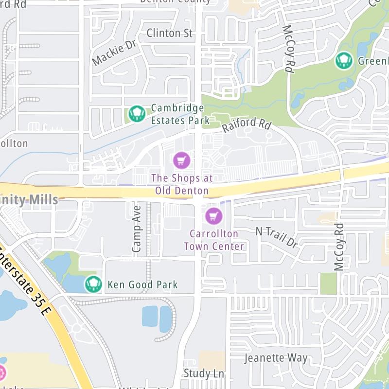
Static map a segment of the President George Bush Turnpike

A Quick Look At The President George Bush Turnpike

This regional toll road serves several key cities, including Dallas, Grand Prairie, Rowlett, Carrollton, Garland, Irving, Richardson, Plano, and Arlington.

The static map seen here shows a segment of The President George Bush Turnpike at Old Denton Road. The entirety of The President George Bush Turnpike can be seen in the fully-interactive map below, which includes linked markers. You may resize and reposition the interactive map to orient the road in relation to other landmarks.

There is also a complete list of exits below the interactive map.

View Map ▾Exit / POI List ▾

What Does It Cost To Use The President George Bush Turnpike?

Tolls For Cars, SUVs, Pickups, etc.

▹ Toll as of July 1, 2023.

The total toll for using the President George Bush Turnpike is $10.94, if you are using a compatible transponder, RFID sticker or other pass.

NOTE: The rates shown are the maximum toll incurred. Your trip may have a lower rate.

Transponders You Can Use

For drivers paying with a transponder, the following passes will work on the President George Bush Turnpike

  • tolltag
  • eztag
  • txtag
  • pikepass
  • k-tag
  • sunpass pro
  • expresstoll

Learn about transponders and accounts in Texas.

Without a compatible pass or transponder, the toll will be $21.88.

View Map ▾All Tolls / Calculator ▸

Our new toll and trip calculator is being constructed. For most roads, you can still use the legacy calculator for current, accurate tolls.

Advertising
Advertising

Using The Interactive Toll Map

You may pan and zoom the interactive map. There are markers you may select for a separate map of that point of interest or location, which will show any nearby dining, gas, EV charging, hotels and other services.

A complete list of exits and other points-of-interest may be found below the map. Exits and gantries will display the toll agency responsible for tolls on that portion of the roadway.

View Map ▾Exit / POI List ▾

Advertising
Advertising

The President George Bush Turnpike Toll Map

This map of the President George Bush Turnpike displays markers for exits and tolling points, which you can select to get a close-up map of that point of interest or location.

The points-of-interest shown on this map are also listed below, ordered from west to east.

Discover Texas Attractions

Advertising
Advertising

List Of Exits / Points Of Interest For The President George Bush Turnpike

Select an exit or other location to get a separate map, including locations of available gas, EV charging, fast-food and other dining options, plus current weather and driving conditions.

I–20

I–20 — Grand Prairie

View Map & Info

▸ GPS 32.676576000 X -97.023577000
NOTES:

NTTA North Texas Tollway Authority manages this segment.

Mayfield Road

Mayfield Road — Grand Prairie

View Map & Info

▸ GPS 32.691765000 X -97.024252000
NOTES:

NTTA North Texas Tollway Authority manages this segment.

Arkansas Mainlane Toll Gantry

Arkansas Mainlane Toll Gantry — Grand Prairie

View Map & Info

▸ GPS 32.702578000 X -97.024535000
NOTES:

NTTA North Texas Tollway Authority manages this segment.

Arkansas Lane / to Pioneer Pkwy

Arkansas Lane / to Pioneer Pkwy — Grand Prairie

View Map & Info

▸ GPS 32.705357000 X -97.024525000
NOTES: SB On/NB Off

NTTA North Texas Tollway Authority manages this segment.

Pioneer Parkway/SPUR 303 / to Arkansas Ln.

Pioneer Parkway/SPUR 303 / to Arkansas Ln. — Grand Prairie

View Map & Info

▸ GPS 32.709774000 X -97.024508000
NOTES: SB Off/NB On

NTTA North Texas Tollway Authority manages this segment.

Marshall Drive

Marshall Drive — Grand Prairie

View Map & Info

▸ GPS 32.721118000 X -97.022436000
NOTES:

NTTA North Texas Tollway Authority manages this segment.

Jefferson Street / Main Street

Jefferson Street / Main Street — Grand Prairie

View Map & Info

▸ GPS 32.741291000 X -97.019927000
NOTES:

NTTA North Texas Tollway Authority manages this segment.

Dalworth Street

Dalworth Street — Grand Prairie

View Map & Info

▸ GPS 32.744618000 X -97.021386000
NOTES: SB On/NB Off

NTTA North Texas Tollway Authority manages this segment.

W Tarrant Road

W Tarrant Road — Grand Prairie

View Map & Info

▸ GPS 32.756881000 X -97.029008000
NOTES: SB On/NB Off

NTTA North Texas Tollway Authority manages this segment.

I–30

I–30 — Grand Prairie

View Map & Info

▸ GPS 32.758922000 X -97.029009000
NOTES:

NTTA North Texas Tollway Authority manages this segment.

Lower Tarrant Road / Egyptian Way

Lower Tarrant Road / Egyptian Way — Grand Prairie

View Map & Info

▸ GPS 32.773501000 X -97.027179000
NOTES: SB On/NB Off

NTTA North Texas Tollway Authority manages this segment.

Lower Tarrant Mainlane Gantry

Lower Tarrant Mainlane Gantry — Grand Prairie

View Map & Info

▸ GPS 32.775896000 X -97.027147000
NOTES:

NTTA North Texas Tollway Authority manages this segment.

Lower Tarrant Road / Egyptian Way

Lower Tarrant Road / Egyptian Way — Grand Prairie

View Map & Info

▸ GPS 32.783155000 X -97.022079000
NOTES: SB Off/NB On

NTTA North Texas Tollway Authority manages this segment.

Oakdale Road

Oakdale Road — Grand Prairie

View Map & Info

▸ GPS 32.792461000 X -97.018402000
NOTES: SB ON/NB Off

NTTA North Texas Tollway Authority manages this segment.

Shady Grove Road / Trinity Boulevard

Shady Grove Road / Trinity Boulevard — Grand Prairie

View Map & Info

▸ GPS 32.803431000 X -97.018186000
NOTES:

NTTA North Texas Tollway Authority manages this segment.

Conflans Road

Conflans Road — Irving

View Map & Info

▸ GPS 32.823948000 X -97.017317000
NOTES:

NTTA North Texas Tollway Authority manages this segment.

SH 183 / Airport Freeway

SH 183 / Airport Freeway — Irving

View Map & Info

▸ GPS 32.836902000 X -97.016720000
NOTES: to DFW

NTTA North Texas Tollway Authority manages this segment.

Northgate Drive

Northgate Drive — Irving

View Map & Info

▸ GPS 32.857293000 X -97.012784000
NOTES:

NTTA North Texas Tollway Authority manages this segment.

W Walnut Hill Lane

W Walnut Hill Lane — Irving

View Map & Info

▸ GPS 32.865669000 X -97.002709000
NOTES:

NTTA North Texas Tollway Authority manages this segment.

N Belt Line Road

N Belt Line Road — Irving

View Map & Info

▸ GPS 32.877055000 X -96.991838000
NOTES:

NTTA North Texas Tollway Authority manages this segment.

Belt Line Main Lane Gantry

Belt Line Main Lane Gantry — Irving

View Map & Info

▸ GPS 32.882844000 X -96.987039000
NOTES:

NTTA North Texas Tollway Authority manages this segment.

Gateway Drive

Gateway Drive — Irving

View Map & Info

▸ GPS 32.889563000 X -96.981143000
NOTES:

NTTA North Texas Tollway Authority manages this segment.

SH 114 / John Carpenter Freeway

SH 114 / John Carpenter Freeway — Irving

View Map & Info

▸ GPS 32.895518000 X -96.972058000
NOTES:

NTTA North Texas Tollway Authority manages this segment.

Royal Lane

Royal Lane — Irving

View Map & Info

▸ GPS 32.897892000 X -96.968466000
NOTES:

NTTA North Texas Tollway Authority manages this segment.

Las Colinas Blvd / to MacArthur Blvd

Las Colinas Blvd / to MacArthur Blvd — Irving

View Map & Info

▸ GPS 32.908035000 X -96.953007000
NOTES:

NTTA North Texas Tollway Authority manages this segment.

I–635 / Lyndon B Johnson Freeway

I–635 / Lyndon B Johnson Freeway — Irving

View Map & Info

▸ GPS 32.912001000 X -96.942897000
NOTES:

NTTA North Texas Tollway Authority manages this segment.

Valley View Lane

Valley View Lane — Carrollton

View Map & Info

▸ GPS 32.916223000 X -96.935133000
NOTES:

NTTA North Texas Tollway Authority manages this segment.

W Belt Line / Luna Road

W Belt Line / Luna Road — Carrollton

View Map & Info

▸ GPS 32.951791000 X -96.925369000
NOTES:

NTTA North Texas Tollway Authority manages this segment.

Sandy Lake Main Lane Gantry

Sandy Lake Main Lane Gantry — Carrollton

View Map & Info

▸ GPS 32.959082000 X -96.929420000
NOTES:

NTTA North Texas Tollway Authority manages this segment.

Sandy Lake Road

Sandy Lake Road — Carrollton

View Map & Info

▸ GPS 32.968645000 X -96.932526000
NOTES:

NTTA North Texas Tollway Authority manages this segment.

I–35E/Stemmons Freeway

I–35E/Stemmons Freeway — Carrollton

View Map & Info

▸ GPS 32.982134000 X -96.930515000
NOTES:

NTTA North Texas Tollway Authority manages this segment.

Old Denton Road

Old Denton Road — Carrollton

View Map & Info

▸ GPS 32.983086000 X -96.910183000
NOTES:

NTTA North Texas Tollway Authority manages this segment.

Josey Lane

Josey Lane — Carrollton

View Map & Info

▸ GPS 32.985286000 X -96.890809000
NOTES:

NTTA North Texas Tollway Authority manages this segment.

Kelly Boulevard

Kelly Boulevard — Addison

View Map & Info

▸ GPS 32.986029000 X -96.869173000
NOTES: WB On/EB Off

NTTA North Texas Tollway Authority manages this segment.

Frankford Main Lane Gantry

Frankford Main Lane Gantry — Addison

View Map & Info

▸ GPS 32.992537000 X -96.862279000
NOTES:

NTTA North Texas Tollway Authority manages this segment.

Frankford Road

Frankford Road — Dallas

View Map & Info

▸ GPS 32.997031000 X -96.859151000
NOTES: WB On/EB Off

NTTA North Texas Tollway Authority manages this segment.

Marsh Lane

Marsh Lane — Dallas

View Map & Info

▸ GPS 33.000905000 X -96.856534000
NOTES: WB Off/EB On

NTTA North Texas Tollway Authority manages this segment.

Rosemeade Parkway / Midway Rd

Rosemeade Parkway / Midway Rd — Dallas

View Map & Info

▸ GPS 33.000898000 X -96.856535000
NOTES:

NTTA North Texas Tollway Authority manages this segment.

Midway Road / Rosemeade Pkwy

Midway Road / Rosemeade Pkwy — Dallas

View Map & Info

▸ GPS 33.012609000 X -96.843647000
NOTES: WB Off/EB On

NTTA North Texas Tollway Authority manages this segment.

Dallas North Tollway

Dallas North Tollway — Dallas

View Map & Info

▸ GPS 33.012562000 X -96.829176000
NOTES:

NTTA North Texas Tollway Authority manages this segment.

Preston Road

Preston Road — Dallas

View Map & Info

▸ GPS 33.012071000 X -96.795612000
NOTES:

NTTA North Texas Tollway Authority manages this segment.

Coit Main Lane Gantry

Coit Main Lane Gantry — Plano

View Map & Info

▸ GPS 33.002367000 X -96.776453000
NOTES:

NTTA North Texas Tollway Authority manages this segment.

Coit Road

Coit Road — Dallas

View Map & Info

▸ GPS 33.002367000 X -96.776453000
NOTES:

NTTA North Texas Tollway Authority manages this segment.

Independence Parkway

Independence Parkway — Dallas

View Map & Info

▸ GPS 33.003092000 X -96.748482000
NOTES:

NTTA North Texas Tollway Authority manages this segment.

Custer Parkway

Custer Parkway — Plano

View Map & Info

▸ GPS 33.003656000 X -96.731909000
NOTES:

NTTA North Texas Tollway Authority manages this segment.

US 75/Central Expressway

US 75/Central Expressway — Richardson

View Map & Info

▸ GPS 33.003793000 X -96.708285000
NOTES:

NTTA North Texas Tollway Authority manages this segment.

Jupiter Road

Jupiter Road — Plano

View Map & Info

▸ GPS 33.002443000 X -96.682287000
NOTES:

NTTA North Texas Tollway Authority manages this segment.

Renner Road

Renner Road — Richardson

View Map & Info

▸ GPS 32.997103000 X -96.671142000
NOTES:

NTTA North Texas Tollway Authority manages this segment.

Shiloh Main Lane Gantry

Shiloh Main Lane Gantry — Richardson

View Map & Info

▸ GPS 32.989422000 X -96.667398000
NOTES:

NTTA North Texas Tollway Authority manages this segment.

Shiloh Road

Shiloh Road — Garland

View Map & Info

▸ GPS 32.980476000 X -96.663814000
NOTES:

NTTA North Texas Tollway Authority manages this segment.

Campbell Road

Campbell Road — Garland

View Map & Info

▸ GPS 32.975164000 X -96.657344000
NOTES:

NTTA North Texas Tollway Authority manages this segment.

North Garland Avenue

North Garland Avenue — Garland

View Map & Info

▸ GPS 32.965976000 X -96.642180000
NOTES:

NTTA North Texas Tollway Authority manages this segment.

Brand Road

Brand Road — Garland

View Map & Info

▸ GPS 32.957033000 X -96.630041000
NOTES: SB On/NB Off

NTTA North Texas Tollway Authority manages this segment.

SH 78/Lavon Drive

SH 78/Lavon Drive — Garland

View Map & Info

▸ GPS 32.950436000 X -96.619133000
NOTES:

NTTA North Texas Tollway Authority manages this segment.

Crist Road

Crist Road — Garland

View Map & Info

▸ GPS 32.947623000 X -96.614229000
NOTES:

NTTA North Texas Tollway Authority manages this segment.

Firewheel Parkway

Firewheel Parkway — Garland

View Map & Info

▸ GPS 32.947292000 X -96.609453000
NOTES:

NTTA North Texas Tollway Authority manages this segment.

Miles Road / Merritt Rd

Miles Road / Merritt Rd — Garland

View Map & Info

▸ GPS 32.950610000 X -96.584274000
NOTES:

NTTA North Texas Tollway Authority manages this segment.

Merritt Road / Miles Rd

Merritt Road / Miles Rd — Garland

View Map & Info

▸ GPS 32.950588000 X -96.570734000
NOTES:

NTTA North Texas Tollway Authority manages this segment.

Merritt Main Lane Gantry

Merritt Main Lane Gantry — Rowlett

View Map & Info

▸ GPS 32.944634000 X -96.559093000
NOTES:

NTTA North Texas Tollway Authority manages this segment.

Merritt Road

Merritt Road — Rowlett

View Map & Info

▸ GPS 32.931917000 X -96.552582000
NOTES:

NTTA North Texas Tollway Authority manages this segment.

Lakeview Parkway/SH 66

Lakeview Parkway/SH 66 — Rowlett

View Map & Info

▸ GPS 32.908040000 X -96.556066000
NOTES:

NTTA North Texas Tollway Authority manages this segment.

Miller Road

Miller Road — Rowlett

View Map & Info

▸ GPS 32.891752000 X -96.556454000
NOTES:

NTTA North Texas Tollway Authority manages this segment.

I–30/US 67

I–30/US 67 — Garland

View Map & Info

▸ GPS 32.857721000 X -96.553948000
NOTES:

NTTA North Texas Tollway Authority manages this segment.

Advertising
Advertising

EXPLORE TEXAS

Journey to key destinations around and adjacent to Texas!

Map Of This Region ▹

Communities in this metro area include Dallas, Fort Worth, Plano, Addison, Frisco, Grand Prairie, Arlington, Carrrollton, and Lake Dallas.

Individual toll maps for this region are listed below.

Map Of This Region ▹

Communities in this metro area include Houston, Humble, Tomball, Sugar Land, Galveston, Pearland, and Katy.

Individual toll maps for this region are listed below.

Map Of This Region ▹

Communities in this metro area include Austin, Pflugerville, Round Rock, Georgetown, Cedar Park, Mustang Ridge, Manor, Serenada, Sunset Valley, and Hutto.

Individual toll maps for this region are listed below.

Map Of This Region ▹

Communities in this metro area include Tyler, Wood Springs, Noonday, and Whitehouse.

Individual toll maps for this region are listed below.

Map Of This Region ▹

Communities in this metro area include Brownsville, Heroica Matamoros, Tamaulipas, San Benito, Harlingen, and Rancho Viejo.

Individual toll maps for this region are listed below.

Map Of This Region ▹

Communities in this metro area include Lawton, Fort Sill, Geronimo, and Cache.

Individual toll maps for this region are listed below.

Advertising
Advertising
Turnpikes.com is proud to partner with the following: