Dallas North Tollway At Belt Line Road

Belt Line Road

At A Glance

This junction is located in Dallas.

This location is in the Dallas - Fort Worth area.

▾ Interactive Map Below ▾

This location's approximate GPS Coordinates are 32.95407 x -96.82191.

Which directions can I travel from here?

From this junction, traffic can enter traveling both southbound and northbound. Traffic can also exit traveling both southbound and northbound.

On to Keller Springs Road, about 1.0 mile away ►

◄ Back to Spring Valley Road, about 1.0 mile away.

Which direction are tolls charged here?

  • ▸ Southbound on ramp
  • ▸ Northbound off ramp
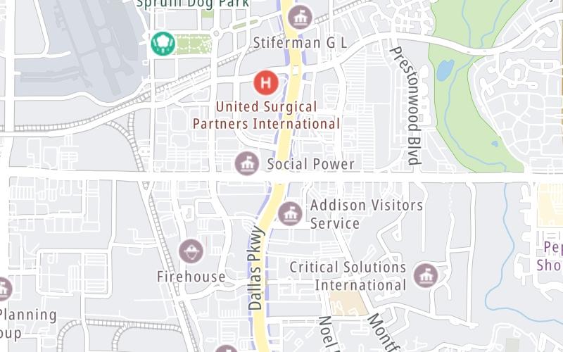
▾ Travel Conditions ▾

Above: Map image © TomTom Intl BV

Using The POI Map

The interactive map and lists on this page include key traveler services within two miles of this destination point.

You will find common services, including gas stations, truck stops, EV charging facilities, fast-food or family restaurants, and hotels. These are displayed on the interactive map as markers, which you can select for more information.

Current driving conditions and weather, along with a more complete list of key services, may be found below the map.

View Map ▾Weather ▾

Static map of Dallas North Tollway at Belt Line Road
Static map. Interactive map is below.

The interactive map shows dining and services near your chosen location: Belt Line Road and the Dallas North Tollway. A detailed summary of food and services around here is shown after the map.

View Map ▾

Advertising
Advertising

Interactive Exit Map With Nearby Gas, Food And Lodging

Area Map & Services Up To Two (2) Miles

Pan and zoom the map as you desire, and select markers for information and other options, including online ordering, where available.

Advertising
Advertising

Travel Conditions At Belt Line Road

Current Weather And Visibility

  • 14 7 02
  • Drizzle

    50°F / 10°C

    Feels Like:

    48°F / 8.9°C

  • Visibility

    3 Mi / 4.8 Km

    3-Hour Precip:

    0.01 In / 0.0 Cm

  • North Northwest
    Winds (NNW)

    5.8 MPH / 9.3 KPH

    Gusts:

    5.8 MPH / 9.3 KPH

▸ Get the full forecast for This Location | The Dallas - Fort Worth area

Available Cameras

LBJ EXPRESS IH635 @ PRESTON EB

LBJ EXPRESS IH635 @ PRESTON EB

Camera Direction: NORTH. Source: TXDOT - Dallas Fort Worth 75230

Cameras Closest To Belt Line Road

Camera Direction: NORTH. Source: TXDOT - Dallas Fort Worth 75230

2.12 Mi

Camera Direction: WEST. Source: TXDOT - Dallas Fort Worth 75240

3.24 Mi

Travel Pictures

No photos …

There are no currently-available photos for this location.

Advertising
Advertising

Food, Gas, EV And Other Services Near Belt Line Road

Fuel, EV and convenience store header

Gas & EV Charging

Closest Gas Stations

7-Eleven

7-ELEVEN

5403 Arapaho Road • 0.50 miles

Store/Fuel Brand: 7-Eleven

Exxon

EXXON

14106 Dallas Parkway • 0.98 miles

Store/Fuel Brand: Exxon

Texaco

TEXACO

14106 Dallas Parkway • 0.98 miles

Store/Fuel Brand: Texaco

OIL AND GAS WHITE ROCK

5001 Spring Valley Road • 0.98 miles

Store/Fuel Brand:

View Map ▴Full List ▾

Closest EV Chargers

Blink

IMT CAPITAL III PRESTONWOOD LP

15480 Dallas Parkway • 0.47 miles

CONNECTOR: IEC62196Type1
POWER: 6 KW @ 208 V
CURRENT: 30 Amp AC1

Blink

ADDISON CIRCLE ONE

15601 Dallas Parkway • 0.53 miles

CONNECTOR: IEC62196Type1
POWER: 7 KW @ 240 V
CURRENT: 30 Amp AC1

ChargePoint

CHARGEPOINT

14675 Dallas Parkway • 0.57 miles

CONNECTOR: IEC62196Type1
POWER: 6 KW @ 240 V
CURRENT: 27 Amp AC1

ChargePoint

CHARGEPOINT

14675 Dallas Parkway • 0.57 miles

CONNECTOR: IEC62196Type1
POWER: 6 KW @ 240 V
CURRENT: 27 Amp AC1

View Map ▴Full List ▾

Coffee, snacks and dining header

Fast Food & Beverage

Closest Fast Food

Fast food refers ONLY to quick-service and take-out diners. All restaurant types are shown on the map below.

McDonald's

MCDONALD'S

15220 Montfort Road • 0.46 miles

CHARLEYS PHILLY STEAKS

15220 Montfort Road • 0.47 miles

PRESTONWOOD VILLAGE II

15203 Knoll Trail Drive • 0.50 miles

Domino's

DOMINO'S

15203 Knoll Trail Drive • 0.51 miles

McDonald's

MCDONALD'S

15220 Arapaho Road • 0.64 miles

CRIS & JOHN

5555 Preston Oaks Road • 0.88 miles

PAPA JOHN'S

5907 Belt Line Road • 0.90 miles

GENGHIS GRILL

4201 Belt Line Road • 0.96 miles

View Map ▴Full List ▾

Hotels and destinations header

Hotels & Airports

Destination Travel

Discover Texas Attractions

Advertising
Advertising

Services Within Two Miles

Lists Include Fuel, EV Charging and Fast Food

Select/Tap Vendors For Info

Open the columns below to show address, phone numbers and available URLs for gas stations, EV charging stations and fast-food dining within about two miles of Belt Line Road and the Dallas North Tollway.

▾ Open For Full Lists ▾

EXPLORE TEXAS

Journey to key destinations around and adjacent to Texas!

Map Of This Region ▹

Communities in this metro area include Dallas, Fort Worth, Plano, Addison, Frisco, Grand Prairie, Arlington, Carrrollton, and Lake Dallas.

Individual toll maps for this region are listed below.

Map Of This Region ▹

Communities in this metro area include Houston, Humble, Tomball, Sugar Land, Galveston, Pearland, and Katy.

Individual toll maps for this region are listed below.

Map Of This Region ▹

Communities in this metro area include Austin, Pflugerville, Round Rock, Georgetown, Cedar Park, Mustang Ridge, Manor, Serenada, Sunset Valley, and Hutto.

Individual toll maps for this region are listed below.

Map Of This Region ▹

Communities in this metro area include Tyler, Wood Springs, Noonday, and Whitehouse.

Individual toll maps for this region are listed below.

Map Of This Region ▹

Communities in this metro area include Brownsville, Heroica Matamoros, Tamaulipas, San Benito, Harlingen, and Rancho Viejo.

Individual toll maps for this region are listed below.

Map Of This Region ▹

Communities in this metro area include Lawton, Fort Sill, Geronimo, and Cache.

Individual toll maps for this region are listed below.

Advertising
Advertising
Turnpikes.com is proud to partner with the following: