Loop 1 Map

Advertising
Advertising

Exits Map For Loop 1

This map of Loop 1 displays markers for exits and tolling points, which you can select to get a close-up map of that point of interest or location.

The points-of-interest shown on this map are also listed below.

See below for more comprehensive information about Loop 1

Advertising
Advertising
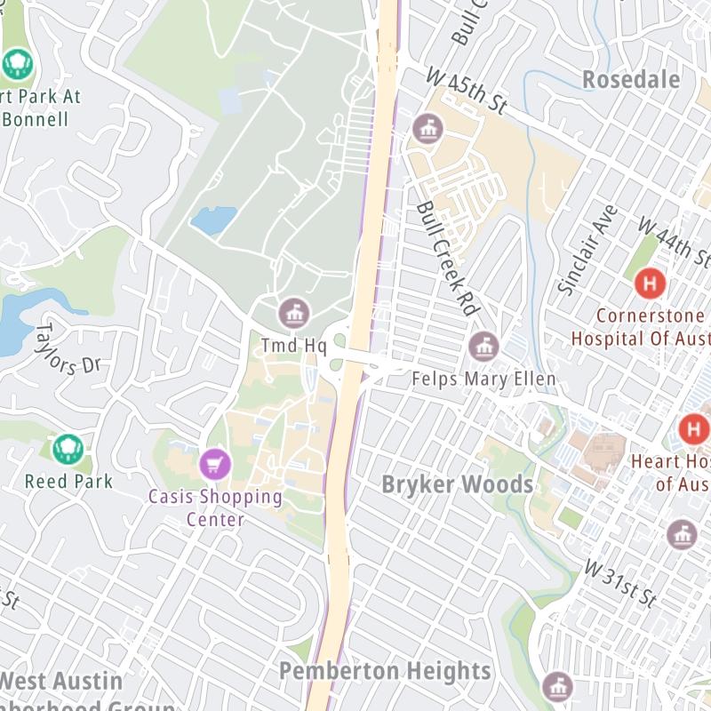
Static map a segment of Loop 1

A Quick Look At Loop 1

This regional toll road serves several key cities, including Austin, Pflugerville, Manchaca, Sunset Valley, Wells Branch, and Bear Creek.

The fixed map seen here presents a quick view of Loop 1 and surrounding area. The fully-interactive map of Loop 1 abvoe includes linked markers. You may resize and reposition the interactive map to orient the road in relation to other landmarks.

There is also a complete list of exits below.

View Map Exit / POI List

Advertising
Advertising

What Does It Cost To Use Loop 1?

Tolls For Cars, SUVs, Pickups, etc.

This data is coming soon.

Transponders You Can Use

For drivers paying with a transponder, the following passes will work on Loop 1

    >

Learn about transponders and accounts in Texas.

View MapAll Tolls / Calculator ▸

Our new toll and trip calculator is being constructed. For most roads, you can still use the legacy calculator for current, accurate tolls.

Discover Texas Attractions

Turnpikes.com has partnered with Tiqets.com to bring you these excusive deals on attractions!

Advertising
Advertising

Travel Alerts

No alerts to display at this time.

Exit/POI List For Loop 1

Selecting an exit or other location opens a separate map with locations of available gas, EV charging, fast-food and other dining options. Current weather and driving conditions will also be shown.

SH 45 SE — Austin

Note(s): South terminus of SH 1/MoPac

GPS 30.173365000 X -97.888690000

TxDoT Texas Department Of Transportation manages this segment.

View Map & Info

La Crosse Ave — Austin

Note(s): None.

GPS 30.190764000 X -97.873930000

TxDoT Texas Department Of Transportation manages this segment.

View Map & Info

W Slaughter Ln — Austin

Note(s): None.

GPS 30.200807000 X -97.866154000

TxDoT Texas Department Of Transportation manages this segment.

View Map & Info

Davis Ln — Austin

Note(s): None.

GPS 30.208036000 X -97.861060000

TxDoT Texas Department Of Transportation manages this segment.

View Map & Info

W William Cannon Dr — Austin

Note(s): None.

GPS 30.220164000 X -97.836645000

TxDoT Texas Department Of Transportation manages this segment.

View Map & Info

71 Toll Road — Austin

Note(s): None.

GPS 30.234894000 X -97.824996000

TxDoT Texas Department Of Transportation manages this segment.

View Map & Info

U.S. Hwy 290 — Austin

Note(s): None.

GPS 30.236171000 X -97.824152000

TxDoT Texas Department Of Transportation manages this segment.

View Map & Info

Southwest Pkwy — Austin

Note(s): SB use this exit for SH 71

GPS 30.237109000 X -97.823074000

TxDoT Texas Department Of Transportation manages this segment.

View Map & Info

SH 360 / S Capital of Texas Hwy — Austin

Note(s): None.

GPS 30.248032000 X -97.804395000

TxDoT Texas Department Of Transportation manages this segment.

View Map & Info

Barton Skyway — Austin

Note(s): None.

GPS 30.262816000 X -97.789589000

TxDoT Texas Department Of Transportation manages this segment.

View Map & Info

Bee Cave Rd — Austin

Note(s): None.

GPS 30.265783000 X -97.782531000

TxDoT Texas Department Of Transportation manages this segment.

View Map & Info

Lake Austin Blvd / W Cesar Chavez St — Austin

Note(s): None.

GPS 30.276954000 X -97.769369000

TxDoT Texas Department Of Transportation manages this segment.

View Map & Info

Enfield Rd — Austin

Note(s): None.

GPS 30.285952000 X -97.763905000

TxDoT Texas Department Of Transportation manages this segment.

View Map & Info

Windsor Rd — Austin

Note(s): None.

GPS 30.292182000 X -97.760031000

TxDoT Texas Department Of Transportation manages this segment.

View Map & Info

Northwood Rd / Westover Rd — Austin

Note(s): None.

GPS 30.300404000 X -97.758268000

TxDoT Texas Department Of Transportation manages this segment.

View Map & Info

W 35th Street — Austin

Note(s): None.

GPS 30.309006000 X -97.757447000

TxDoT Texas Department Of Transportation manages this segment.

View Map & Info

W 45th Streeet — Austin

Note(s): NB entrance via Highland Ter

GPS 30.321390000 X -97.755935000

TxDoT Texas Department Of Transportation manages this segment.

View Map & Info

Northland Dr — Austin

Note(s): None.

GPS 30.321390000 X -97.755935000

TxDoT Texas Department Of Transportation manages this segment.

View Map & Info

Far W Blvd — Austin

Note(s): None.

GPS 30.351775000 X -97.749006000

TxDoT Texas Department Of Transportation manages this segment.

View Map & Info

W Anderson Ln / Spicewood Springs Rd — Austin

Note(s): None.

GPS 30.361264000 X -97.744634000

TxDoT Texas Department Of Transportation manages this segment.

View Map & Info

Steck Ave — Austin

Note(s): SB use exit for Anderson / Spicewood

GPS 30.368174000 X -97.742518000

TxDoT Texas Department Of Transportation manages this segment.

View Map & Info

U.S. Hwy 183 — Austin

Note(s): None.

GPS 30.379538000 X -97.737980000

TxDoT Texas Department Of Transportation manages this segment.

View Map & Info

SH 360 / N Capital of Texas Hwy — Austin

Note(s): None.

GPS 30.389890000 X -97.734348000

TxDoT Texas Department Of Transportation manages this segment.

View Map & Info

W Braker Ln — Austin

Note(s): None.

GPS 30.395788000 X -97.732755000

TxDoT Texas Department Of Transportation manages this segment.

View Map & Info

Duval Rd — Austin

Note(s): None.

GPS 30.408463000 X -97.715985000

TxDoT Texas Department Of Transportation manages this segment.

View Map & Info

Parmer Ln — Austin

Note(s): South terminus of toll road

GPS 30.420362000 X -97.704280000

TxDoT Texas Department Of Transportation manages this segment.

View Map & Info

Howard Ln / Wells Branch Pkwy — Austin

Note(s): None.

GPS 30.440285000 X -97.698310000

TxDoT Texas Department Of Transportation manages this segment.

View Map & Info

Mainline Toll Plaza — Austin

Note(s): None.

GPS 30.453050000 X -97.696717000

TxDoT Texas Department Of Transportation manages this segment.

View Map & Info

Shoreline Dr — Austin

Note(s): No SB exit

GPS 30.460347000 X -97.699194000

TxDoT Texas Department Of Transportation manages this segment.

View Map & Info

SH 45 N — Austin

Note(s): North terminus of toll road

GPS 30.475194000 X -97.702650000

TxDoT Texas Department Of Transportation manages this segment.

View Map & Info

Advertising
Advertising

EXPLORE TEXAS

Journey to key destinations around and adjacent to Texas!

Map Of This Region ▹

Communities in this metro area include Dallas, Fort Worth, Plano, Addison, Frisco, Grand Prairie, Arlington, Carrrollton, and Lake Dallas.

Individual toll maps for this region are listed below.

Map Of This Region ▹

Communities in this metro area include Houston, Humble, Tomball, Sugar Land, Galveston, Pearland, and Katy.

Individual toll maps for this region are listed below.

Map Of This Region ▹

Communities in this metro area include Austin, Pflugerville, Round Rock, Georgetown, Cedar Park, Mustang Ridge, Manor, Serenada, Sunset Valley, and Hutto.

Individual toll maps for this region are listed below.

Map Of This Region ▹

Communities in this metro area include Tyler, Wood Springs, Noonday, and Whitehouse.

Individual toll maps for this region are listed below.

Map Of This Region ▹

Communities in this metro area include Brownsville, Heroica Matamoros, Tamaulipas, San Benito, Harlingen, and Rancho Viejo.

Individual toll maps for this region are listed below.

Map Of This Region ▹

Communities in this metro area include Lawton, Fort Sill, Geronimo, and Cache.

Individual toll maps for this region are listed below.

Advertising
Advertising
Turnpikes.com is proud to partner with the following: