Ohio Turnpike At Maumee/Toledo / US 20

Advertising
Advertising

Map & services within two (2) miles

Interactive map shows available cameras, plus nearby fuel, food and lodging

See below for more about this area

Advertising
Advertising

About This Location

Maumee/Toledo / US 20

At A Glance

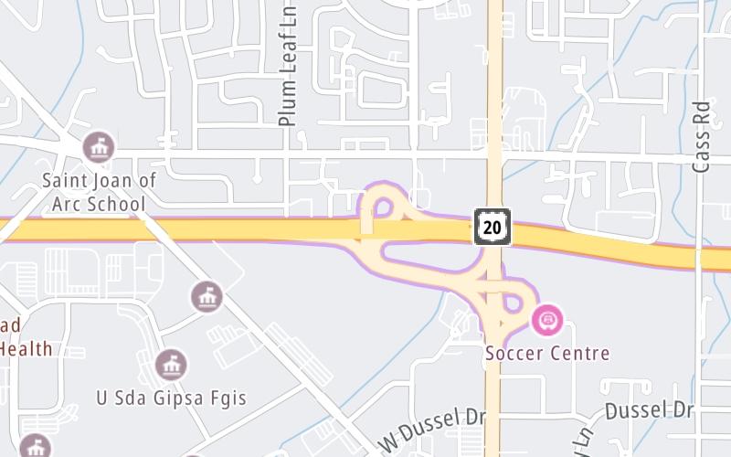
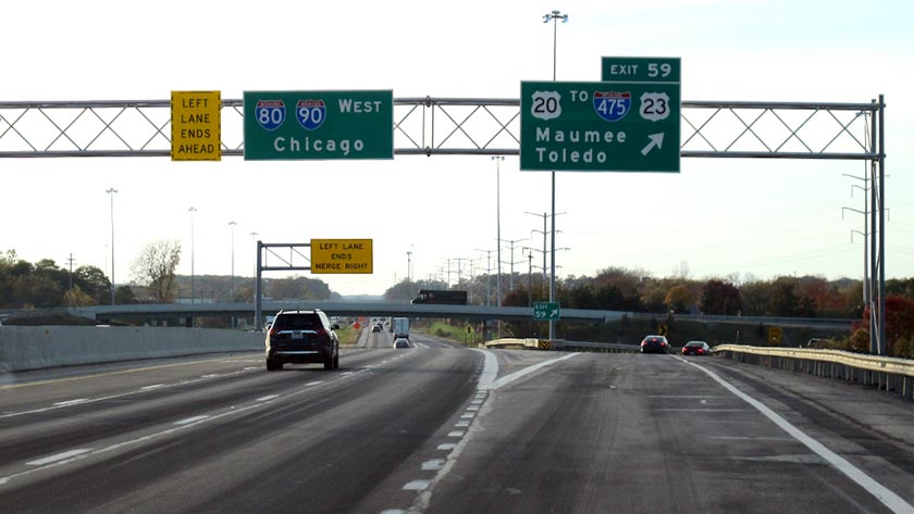
This is Exit 59 of the Ohio Turnpike.

This junction is located in Toledo.

This location is in the Toledo - Western Ohio area.

Interactive Map Above

This location's approximate GPS Coordinates are 41.59200 x -83.67080.

Which directions can I travel from here?

From this junction, traffic can enter traveling both westbound and eastbound. Traffic can also exit traveling both westbound and eastbound.

On to Perrysburg/Toledo / I-75, about 5.4 miles away ►

◄ Back to Toledo Airport/Swanton / SR 2, about 6.9 miles away.

This location also connects with Michigan.

Which direction are tolls charged here?

  • ▸ Westbound on ramp
  • ▸ Westbound off ramp
  • ▸ Eastbound on ramp
  • ▸ Eastbound off ramp

View Map Travel Conditions

Above: Photo by Turnpikes.com

Using The POI Map

The interactive map and lists on this page include key traveler services within two miles of this destination point.

You will find common services, including gas stations, truck stops, EV charging facilities, fast-food or family restaurants, and hotels. These are displayed on the interactive map as markers, which you can select for more information.

Current driving conditions and weather, along with a more complete list of key services, may be found below the map.

View Map Weather

Static map of Ohio Turnpike at Maumee/Toledo / US 20
Static map. Interactive map is above.
Advertising
Advertising

Travel Conditions At Maumee/Toledo / US 20

Current Weather And Visibility

  • 07 7 04
  • Clear

    50°F / 9.9°C

    Feels Like:

    49°F / 9.7°C

  • Visibility

    2 Mi / 3.2 Km

    3-Hour Precip:

    0 In / 0.0 Cm

  • North
    Winds (N)

    4.3 MPH / 7 KPH

    Gusts:

    9.6 MPH / 15.5 KPH

▸ Get the full forecast for This Location | The Toledo - Western Ohio area

Available Cameras

I-475 @ SALISBURY RD

I-475 @ SALISBURY RD

Camera Direction: NORTH. Source: ODOT - Toledo 43537

Cameras Closest To Maumee/Toledo / US 20

Camera Direction: NORTH. Source: ODOT - Toledo 43537

1.27 Mi

Camera Direction: UNKNOWN. Source: ODOT - undetermined 43528

1.76 Mi

Camera Direction: EAST. Source: ODOT - Toledo 43528

2.18 Mi

Camera Direction: SOUTH. Source: ODOT - Toledo 43615

3.30 Mi

Camera Direction: SOUTH. Source: ODOT - Toledo 43551

3.81 Mi

Advertising
Advertising

Travel Pictures

Pictures Around Maumee/Toledo / US 20

About this photo:
The westbound exit ramp to Maumee, via Exit 59, from the Ohio Turnpike. Photo taken November 1, 2019.

Photo taken 11-01-2019

More Pictures Near Maumee/Toledo / US 20

Photo taken 11-01-2019
Advertising
Advertising

Closest Food, Gas, EV And Other Services Near Maumee/Toledo / US 20

The map above shows all services within about a two (2) mile radius.

Hotels and destinations header

Hotels & Airports

Destination Travel

Fuel, EV and convenience store header

Gas & EV Charging

Closest Gas Stations

TRUE NORTH

298 West Dussel Drive • 0.55 miles

Store/Fuel Brand: True North

TRUE NORTH

2202 South Reynolds Road • 0.63 miles

Store/Fuel Brand: True North

Speedway

SPEEDWAY

5925 Heatherdowns Boulevard • 0.63 miles

Store/Fuel Brand: Speedway

KROGER

1429 South Reynolds Road • 0.65 miles

Store/Fuel Brand:

View Map

Closest EV Chargers

JIM WHITE HONDA

1511 South Reynolds Road • 0.42 miles

CONNECTOR: IEC62196Type1
POWER: 12 KW @ 240 V
CURRENT: 50 Amp AC1

CHARGEPOINT

1505 South Reynolds Road • 0.48 miles

CONNECTOR: IEC62196Type1
POWER: 6 KW @ 240 V
CURRENT: 27 Amp AC1

CORNERSTONE CHURCH

1520 South Reynolds Road • 0.61 miles

CONNECTOR: IEC62196Type1
POWER: 11 KW @ 240 V
CURRENT: 48 Amp AC1

MEIJER PHARMACY

1391 Conant Street • 0.95 miles

CONNECTOR: IEC62196Type1
POWER: 7 KW @ 240 V
CURRENT: 30 Amp AC1

View Map

Coffee, snacks and dining header

Fast Food & Beverage

Closest Fast Food

Fast food refers ONLY to quick-service and take-out diners. All restaurant types are shown on the map above.

Domino's

DOMINO'S PIZZA

2336 South Reynolds Road • 0.48 miles

BARRY BAGELS MAUMEE

302 West Dussel Drive • 0.61 miles

ZOUP!

310 West Dussel Drive • 0.63 miles

McDonald's

MCDONALD'S

2130 South Reynolds Road • 0.68 miles

SCHLOTZSKY'S

1419 South Reynolds Road • 0.69 miles

STEAK 'N SHAKE

2141 South Reynolds Road • 0.70 miles

THE ORIGINAL GINO'S PIZZA

449 West Dussel Drive • 0.76 miles

Wingstop

WINGSTOP

1399 Conant Street • 0.82 miles

View Map

Discover Ohio Attractions

Advertising
Advertising

EXPLORE OHIO

Journey to key destinations around and adjacent to Ohio!

Map Of This Region ▹

Communities in this metro area include Cleveland, Akron, Boardman, Lorain, Aurora, Youngstown, New Castle, Pennsylvania, and Beaver Falls, Pennsylvania.

Individual toll maps for this region are listed below.

Map Of This Region ▹

Communities in this metro area include Toledo, Perrysburg, Maumee, Montpelier, and Wauseon.

Individual toll maps for this region are listed below.

Map Of This Region ▹

Communities in this metro area include Castalia, Sandusky, Norwalk, Bellevue, Huron, Milan, and Monroeville.

Individual toll maps for this region are listed below.

Map Of This Region ▹

Communities in this metro area include Columbus, Upper Arlington, Westerville, New Albany, Worthington, Dublin, Pickerington, and Reynoldsburg.

Individual toll maps for this region are listed below.

columbus-state capital

Roads Within Region

Map Of This Region ▹

Map Of This Region ▹

Communities in this metro area include Cincinnati, Norwood, Cheviot, Northbrook, Reading, Covington, Kentucky, and Newport, Kentucky.

Individual toll maps for this region are listed below.

cincinnati-covington

Roads Within Region

Map Of This Region ▹

Map Of This Region ▹

Communities in this metro area include Gary, South Bend, Elkhart, Portage, and Fremont.

Individual toll maps for this region are listed below.

Map Of This Region ▹

Communities in this metro area include Pittsburgh, Cranberry Township, Beaver Valley, New Castle, Washington, Uniontown, Cheat Lake, West Virginia, Boardman, Ohio, and Youngstown, Ohio.

Individual toll maps for this region are listed below.

Map Of This Region ▹

Communities in this metro area include Parkersburg, North Hills, Vienna, and Belpre, Ohio.

Individual toll maps for this region are listed below.

Map Of This Region ▹

Communities in this metro area include Detroit, Grosse Ile, Ann Arbor, Pontiac, and Lansing.

Individual toll maps for this region are listed below.

Advertising
Advertising
Turnpikes.com is proud to partner with the following: