Ohio Turnpike At Elmore/Woodville/Gibsonburg / SR 51

Static map of Ohio Turnpike at Elmore/Woodville/Gibsonburg / SR 51

Using The POI Map

A summary of the closest services around the Ohio Turnpike and Elmore/Woodville/Gibsonburg / SR 51 is shown below. More complete detail follows the overview.

Area Overview ▾View Map ▾

The interactive map and lists on this page include key traveler services within two miles of this destination point, including gas stations, truck stops, EV charging facilities, fast-food or family restaurants, and hotels. These are displayed on the interactive map as markers, which you can select for more information.

Current driving conditions and weather, along with a more complete list of key services, may be found below the map.

View Map ▾Weather ▾

Advertising
Advertising

Interactive Exit Map With Nearby Gas, Food And Lodging

Elmore/Woodville/Gibsonburg / SR 51

At A Glance

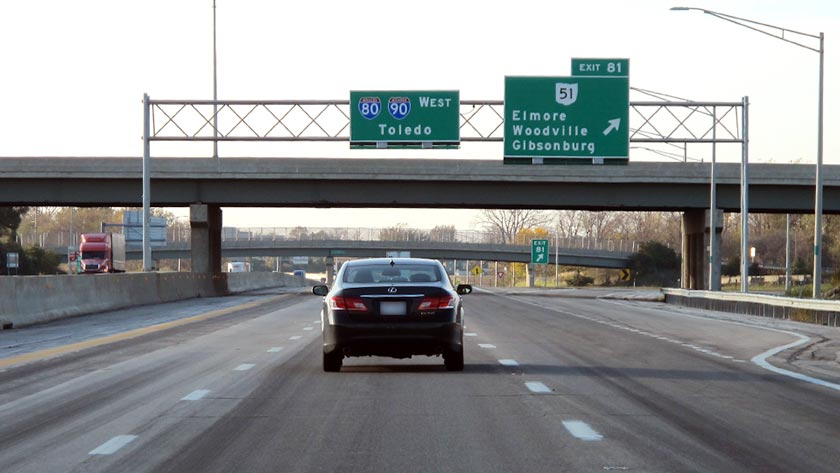
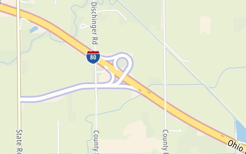
This is Exit 81 of the Ohio Turnpike.

This junction is located in Elmore.

This location is in the Sandusky - Sandusky Bay area.

See the adjacent map for detail.▾ Interactive Map Below ▾

This location's approximate GPS Coordinates are 41.45870 x -83.28500.

Which directions can I travel from here?

From this junction, traffic can enter traveling both westbound and eastbound. Traffic can also exit traveling both westbound and eastbound.

The next exit is Fremont/Port Clinton / SR 53, approximately 9.8 miles away ►

◄ The previous exit is Wynadot Service Plaza, approximately 4.9 miles away.

Which direction are tolls charged here?

  • ▸ Westbound on ramp
  • ▸ Westbound off ramp
  • ▸ Eastbound on ramp
  • ▸ Eastbound off ramp

▾ Travel Conditions ▾

Above: Photo by Turnpikes.com

Area Map & Services Up To Two (2) Miles

Pan and zoom the map as you desire, and select markers for information and other options, including online ordering, where available.

Advertising
Advertising

Food, Gas, EV And Other Services Near Elmore/Woodville/Gibsonburg / SR 51

Fuel, EV and convenience store header

Gas & EV Charging

Closest Gas Stations

Marathon

MARATHON

331 Harris Street • 1.33 miles

Store/Fuel Brand: Marathon

View Map ▴

Closest EV Chargers

CHARGEPOINT

307 Maple Street • 1.24 miles

CONNECTOR: IEC62196Type1
POWER: 6 KW @ 240 V
CURRENT: 27 Amp AC1

View Map ▴

Coffee, snacks and dining header

Fast Food & Beverage

Closest Fast Food

Fast food refers ONLY to quick-service and take-out diners. All restaurant types are shown on the map below.

View Map ▴Full List ▾

No fast-food dining nearby.

Coffee, snacks and dining header

Hotels & Airports

Destination Travel

Hotels closest to Elmore/Woodville/Gibsonburg / SR 51.

Advertising
Advertising

Travel Conditions At Elmore/Woodville/Gibsonburg / SR 51

Current Weather And Visibility

  • 05 6 07
  • Clear

    62°F / 16.4°C

    Feels Like:

    63°F / 17.2°C

  • Visibility

    4 Mi / 6.4 Km

    3-Hour Precip:

    0 In / 0.0 Cm

  • North
    Winds (N)

    1.1 MPH / 1.7 KPH

    Gusts:

    2.4 MPH / 3.8 KPH

▸ Get the full forecast for This Location | The Sandusky - Sandusky Bay area

Available Cameras

No camera feed …

There is no currently-available traffic camera feed for this location.

Travel Pictures

Pictures Around Elmore/Woodville/Gibsonburg / SR 51

About this photo:
Ohio Turnpike WB at the ramp to Exit 81, which takes drivers under the overpass that leads to OH 51. Photo taken November 1, 2019.

Photo taken 11-01-2019

More Pictures Near Elmore/Woodville/Gibsonburg / SR 51

Photo taken 11-01-2019
Advertising
Advertising

Services Within Two Miles

Lists Include Fuel, EV Charging and Fast Food

Select/Tap Vendors For Info

Vendors within about two miles of Elmore/Woodville/Gibsonburg / SR 51 and the Ohio Turnpike are listed, sorted by distance, with the closest displayed on top. Select/tap the vendor name to show address, phone numbers and available URLs for gas stations, EV charging stations and fast-food dining. Links will open in a new window. Turnpikes.com is not responsible for third-party website content.

Gas/Diesel/Liquid Fuels

Fuels Within Two (2) Miles
Marathon

MARATHON

• 1.33 miles

EV Charging/Tesla Superchargers

EV & Tesla Stations Within Two (2) Miles

CHARGEPOINT

• 1.24 miles

Fast-Food/Take-Out Dining

Fast-Food Restaurants Within Two (2) Miles

This list only includes quick-service and take-out restaurants. All nearby restaurants are shown on the map above.

No fast food diners or restaurants nearby.

EXPLORE OHIO

Journey to key destinations around and adjacent to Ohio!

Map Of This Region ▹

Communities in this metro area include Cleveland, Akron, Boardman, Lorain, Aurora, Youngstown, New Castle, Pennsylvania, and Beaver Falls, Pennsylvania.

Individual toll maps for this region are listed below.

Map Of This Region ▹

Communities in this metro area include Toledo, Perrysburg, Maumee, Montpelier, and Wauseon.

Individual toll maps for this region are listed below.

Map Of This Region ▹

Communities in this metro area include Castalia, Sandusky, Norwalk, Bellevue, Huron, Milan, and Monroeville.

Individual toll maps for this region are listed below.

Map Of This Region ▹

Communities in this metro area include Gary, South Bend, Elkhart, Portage, and Fremont.

Individual toll maps for this region are listed below.

Map Of This Region ▹

Communities in this metro area include Pittsburgh, Cranberry Township, Beaver Valley, New Castle, Washington, Uniontown, Cheat Lake, West Virginia, Boardman, Ohio, and Youngstown, Ohio.

Individual toll maps for this region are listed below.

Map Of This Region ▹

Communities in this metro area include Parkersburg, North Hills, Vienna, and Belpre, Ohio.

Individual toll maps for this region are listed below.

Map Of This Region ▹

Communities in this metro area include Detroit, Grosse Ile, Ann Arbor, Pontiac, and Lansing.

Individual toll maps for this region are listed below.

detroit-southeast lower peninusula

Roads Within Region

Map Of This Region ▹

Advertising
Advertising