A Quick Look At The Tri State Tollway

I 94 and I 294 are other names for this facility. This state toll road serves several key cities, including Chicago, Oak Lawn, Elmhurst, Des Plaines, Waukegan, and Mt Prospect.
This road traverses the Northern Indiana as well as the Chicagoland - Northwestern Indiana areas.
A complete list of exits can be found below.
View Map Exit / POI List
Latest Travel Alert
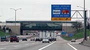
CONSTRUCTION - Tri State Tollway
Monday March 30, 2026 — Friday April 24, 2026
The ramp connecting the northbound Tri-State Tollway (I-294) to I-190 and River Road is scheduled to be reduced to a single lane beginning the week of March 30 and continuing into April for ongoing plaza improvements at the O?Hare Interchange. Dela… Full details below
Impacted area(s):
See all travel alerts
How To Pay On the Tri State Tollway
Accepted types of payment taken while on the road
Payment Type
Tag
Plate
Cash
Card
App
Available when checked
Tag
Plate
No cash
No card
App
The Tri State Tollway offers license-plate tolling for those without a compatible transponder.
Transponders You Can Use
For drivers with a transponder, the following passes can be used on the Tri State Tollway

- e-zpass
- epass xtra
- i-pass
- quick pass
- riverlink
- sunpass pro
- uni
Learn about transponders and accounts in Illinois.
View MapToll CalculatorAll Illinois Tolls
Our new toll and trip calculator is complete, but many roads' data are still being entered into our database. The legacy calculator remains active for current, accurate tolls.


 Illinois Tollway
 Chicago Skyway ▹
 Jane Addams Memorial Tollway ▹
 Ronald Reagan Memorial Tollway ▹
 Tri State Tollway ▹
 Veterans Memorial Tollway ▹
 Cline Avenue Bridge ▹
 Illinois Route 390 ▹
 Houbolt Road Extension ▹
 Indiana Toll Road ▹
 Ohio Turnpike ▹


