Indiana Toll Road At Ernie Pyle Travel Plaza

Ernie Pyle Travel Plaza

At A Glance

NOTICE! Data for this plaza/rest stop is being updated.

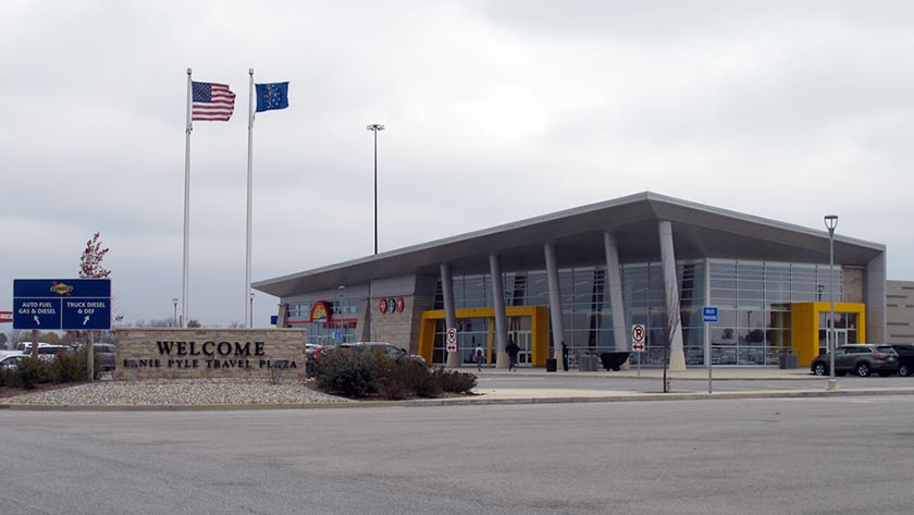
This travel plaza is located in Howe.

This location is in the Northern Indiana area.

▾ Interactive Map Below ▾

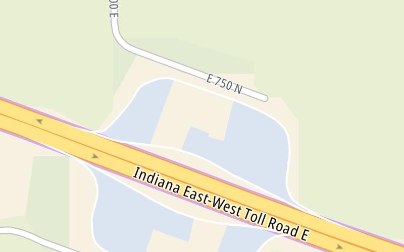
This location's approximate GPS Coordinates are 41.74692 x -85.32870.

The next exit is Gene S. Porter Travel Plaza, approximately 0.0 miles away ►

◄ The previous exit is SR 9, approximately 5.3 miles away.

▾ Travel Conditions ▾

Above: Photo by Turnpikes.com

Using The POI Map

The interactive map and lists on this page include key traveler services within two miles of this destination point.

You will find common services, including gas stations, truck stops, EV charging facilities, fast-food or family restaurants, and hotels. These are displayed on the interactive map as markers, which you can select for more information.

Current driving conditions and weather, along with a more complete list of key services, may be found below the map.

View Map ▾Weather ▾

Static map of Indiana Toll Road at Ernie Pyle Travel Plaza
Static map. Interactive map is below.

A summary of the closest services around the Indiana Toll Road and Ernie Pyle Travel Plaza is shown below. More complete detail follows the map.

View Map ▾

Advertising
Advertising

Interactive Exit Map With Nearby Gas, Food And Lodging

Area Map & Services Up To Two (2) Miles

Pan and zoom the map as you desire, and select markers for information and other options, including online ordering, where available.

Advertising
Advertising

Travel Conditions At Ernie Pyle Travel Plaza

Current Weather And Visibility

  • 06 7 10
  • Cloudy

    47°F / 8.5°C

    Feels Like:

    47°F / 8.6°C

  • Visibility

    7 Mi / 11.3 Km

    3-Hour Precip:

    0 In / 0.0 Cm

  • South Southeast
    Winds (SSE)

    3.8 MPH / 6.1 KPH

    Gusts:

    6.2 MPH / 10 KPH

▸ Get the full forecast for This Location | The Northern Indiana area

Available Cameras

No camera feed …

There is no currently-available traffic camera feed for this location.

Travel Pictures

Pictures Around Ernie Pyle Travel Plaza

About this photo:
Ernie Pyle Travel Plaza, entrance and passenger vehicle lot. Photo taken November 2, 2019.

Photo taken 11-02-2019

More Pictures Near Ernie Pyle Travel Plaza

Photo taken 11-02-2019
Advertising
Advertising

Food, Gas, EV And Other Services Near Ernie Pyle Travel Plaza

Fuel, EV and convenience store header

Gas & EV Charging

Closest Gas Stations

Mobil

MOBIL

• 154 feet

Store/Fuel Brand: Mobil

Mobil

MOBIL

• 605 feet

Store/Fuel Brand: Mobil

View Map ▴

Closest EV Chargers

Tesla

TESLA SUPERCHARGER

126 Mile Post 1-90 West • 252 feet

CONNECTOR: Tesla
POWER: 250 KW @ 400 V
CURRENT: 625 Amp DC

Tesla

HOWE - ERNIE PYLE TRAVEL PLAZA, IN SUPERCHARGER

Ernie Pyle Travel Plaza Westbound • 271 feet

CONNECTOR: Tesla
POWER: 250 KW @ 400 V
CURRENT: 625 Amp DC

Tesla

TESLA SUPERCHARGER

7065 North 475 East • 810 feet

CONNECTOR: Tesla
POWER: 250 KW @ 400 V
CURRENT: 625 Amp DC

Tesla

HOWE - GENE STRATTON TRAVEL PLAZA, IN SUPERCHARGER

Gene Stratton Porter Travel Plaza Eastbound • 834 feet

CONNECTOR: Tesla
POWER: 250 KW @ 400 V
CURRENT: 625 Amp DC

View Map ▴

Coffee, snacks and dining header

Fast Food & Beverage

Closest Fast Food

Fast food refers ONLY to quick-service and take-out diners. All restaurant types are shown on the map below.

HARDEE'S

• 29 feet

FAZOLI'S

• 29 feet

Popeyes

POPEYES

• 88 feet

FAZOLI'S

• 731 feet

HARDEE'S

• 731 feet

View Map ▴Full List ▾

Coffee, snacks and dining header

Hotels & Airports

Destination Travel

Hotels closest to Ernie Pyle Travel Plaza.

Discover Indiana Attractions

Advertising
Advertising

Services Within Two Miles

Lists Include Fuel, EV Charging and Fast Food

Select/Tap Vendors For Info

Vendors within about two miles of Ernie Pyle Travel Plaza and the Indiana Toll Road are listed, sorted by distance, with the closest displayed on top. Select/tap the vendor name to show address, phone numbers and available URLs for gas stations, EV charging stations and fast-food dining. Links will open in a new window. Turnpikes.com is not responsible for third-party website content.

Gas/Diesel/Liquid Fuels

Fuels Within Two (2) Miles

EV Charging/Tesla Superchargers

EV & Tesla Stations Within Two (2) Miles

Fast-Food/Take-Out Dining

Fast-Food Restaurants Within Two (2) Miles

This list only includes quick-service and take-out restaurants. All nearby restaurants are shown on the map above.

No fast food diners or restaurants nearby.

EXPLORE INDIANA

Journey to key destinations around and adjacent to Indiana!

Map Of This Region ▹

Communities in this metro area include Gary, South Bend, Elkhart, Portage, and Fremont.

Individual toll maps for this region are listed below.

Map Of This Region ▹

Communities in this metro area include Chicago, Aurora, Oak Lawn, Des Plaines, Waukegan, Highland Park, Gary, Indiana, Schaumburg, Naperville, Oak Brook, and Joliet.

Individual toll maps for this region are listed below.

Map Of This Region ▹

Communities in this metro area include Louisville and Jeffersonville, Indiana.

Individual toll maps for this region are listed below.

Map Of This Region ▹

Communities in this metro area include Toledo, Perrysburg, Maumee, Montpelier, and Wauseon.

Individual toll maps for this region are listed below.

Map Of This Region ▹

Communities in this metro area include Detroit, Grosse Ile, Ann Arbor, Pontiac, and Lansing.

Individual toll maps for this region are listed below.

Advertising
Advertising
Turnpikes.com is proud to partner with the following: