Share

Delaware Turnpike At SR 896 / S College Ave

Advertising
Advertising

About This Location

SR 896 / S College Ave
Photo by Turnpikes.com

At A Glance

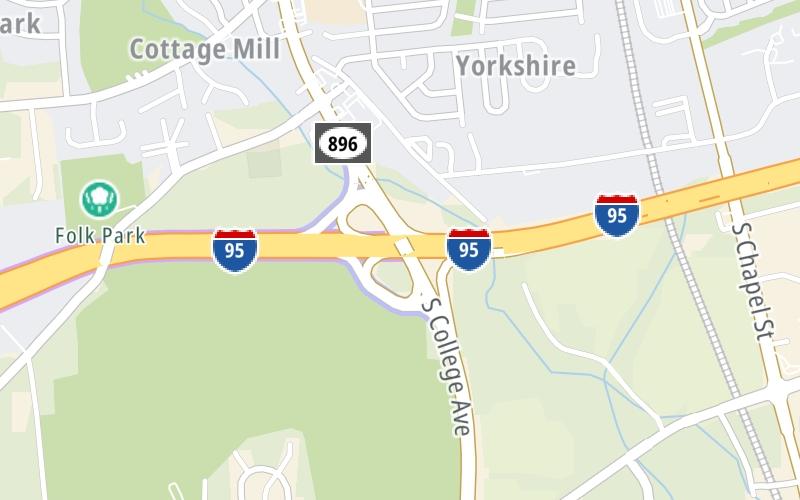
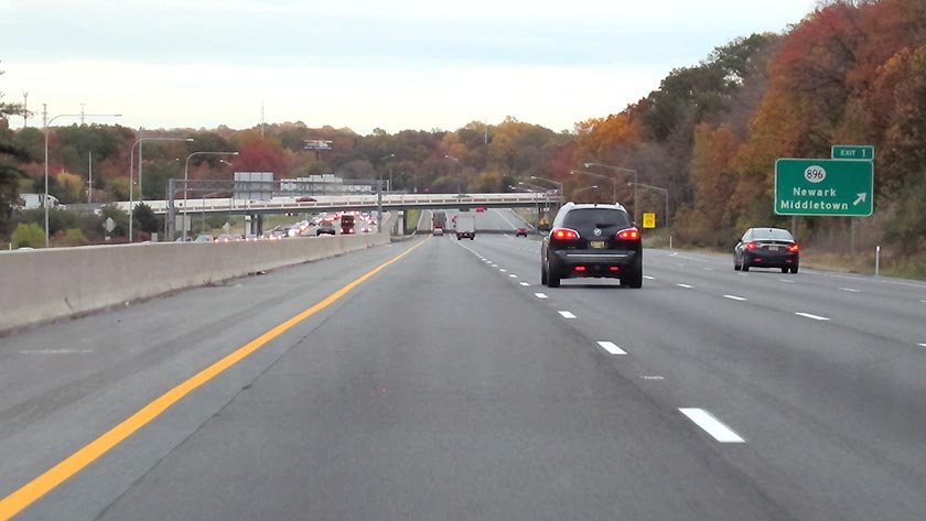
This is Exit 1 of the Delaware Turnpike.

This junction is located in Newark. Middletown is nearby.

This location is in the Wilmington - Newark area.

Interactive Map Below

This location's approximate GPS Coordinates are 39.64677 x -75.74624.

Which directions can I travel from here?

From this junction, traffic can enter traveling both southbound and northbound. Traffic can also exit traveling both southbound and northbound.

On to Delaware House Travel Plaza, about 3.1 miles away ►

◄ Back to JFK Memorial Hwy, about 2.2 miles away.

This location also connects with Maryland.

Which direction are tolls charged here?

Tolls are not charged or collected at this junction.

View Map Travel Conditions

Closest Food, Gas, EV And Other Services Near SR 896 / S College Ave

Use the map below for all services within about a two (2) mile radius.

Fuel, EV and convenience store header

Gas & EV Charging

Closest Gas Stations

Shell

SHELL

1005 South College Avenue • 0.47 miles

Store/Fuel Brand: Shell

Exxon

EXXON

820 South College Avenue • 0.58 miles

Store/Fuel Brand: Exxon

Shell

SHELL

804 South College Avenue • 0.65 miles

Store/Fuel Brand: Shell

ROYAL FARMS

865 Old Baltimore Pike • 0.93 miles

Store/Fuel Brand: Royal Farms

View Map

Closest EV Chargers

Tesla

NEWARK, DE - OLD BALTIMORE PIKE SUPERCHARGER

865 Old Baltimore Pike • 0.95 miles

Tesla

NEWARK, DE - CHESTNUT HILL RD SUPERCHARGER

274 East Chestnut Hill Road • 1.20 miles

Blink

UNIVERSITY OF DELAWARE FINTECH PARKING LOT

540 South College Avenue • 1.32 miles

ChargePoint

CHARGEPOINT

468 South College Avenue • 1.63 miles

View Map

Coffee, snacks and dining header

Fast Food & Beverage

Closest Fast Food

Fast food refers ONLY to quick-service and take-out diners. All restaurant types are shown on the map below.

CHINA GARDEN

1015 South College Avenue • 0.42 miles

MARIO'S PIZZA

1011 South College Avenue • 0.43 miles

Dunkin'

DUNKIN'

1002 South College Avenue • 0.49 miles

McDonald's

MCDONALD'S

815 South College Avenue • 0.62 miles

NICK & JOE'S PIZZA

150 Pencader Plaza • 0.97 miles

JERSEY MIKE'S SUBS

1107 South College Avenue • 1,843 feet

Dunkin'

DUNKIN'

25 Pencader Plz • 1.08 miles

BURGER KING

BURGER KING

680 Four Seasons Parkway • 1.38 miles

View Map

Advertising
Advertising

Interactive POI Map

The interactive map and lists on this page include key traveler services in a two-mile radius, including gas stations, truck stops, EV charging facilities, fast-food or family restaurants, and hotels.

Current driving conditions and weather, may be found below.

Advertising
Advertising

Travel Conditions At SR 896 / S College Ave

Current Weather And Visibility

  • 12 7 12
  • Mostly Clear

    16°F / -8.9°C

    Feels Like:

    15°F / -9.4°C

  • Visibility

    2 Mi / 2.4 Km

    3-Hour Precip:

    0 In / 0.0 Cm

  • West Northwest
    Winds (WNW)

    3.9 MPH / 6.3 KPH

    Gusts:

    8 MPH / 12.9 KPH

▸ Get the full forecast for This Location | The Wilmington - Newark area

Available Cameras

No camera feed …

There is no currently-available traffic camera feed for this location.

Advertising
Advertising

Pictures At SR 896 / S College Ave

View approaching Exit 1 on the northbound lanes of the Delaware Turnpike. Photo taken October 29, 2019. Photo taken 10-29-2019

Advertising
Advertising

Discover Delaware Attractions

Hotels and destinations header

Hotels & Airports

Destination Travel

Advertising
Advertising

EXPLORE DELAWARE

Journey to key destinations around and adjacent to Delaware!

Map Of This Region ▹

Communities in this metro area include Wilmington, Middletown, Newark, and Carneys Point, New Jersey.

Individual toll maps for this region are listed below.

Map Of This Region ▹

Communities in this metro area include Camden, Dover, Dover Afb, and Smyrna.

Individual toll maps for this region are listed below.

Map Of This Region ▹

Communities in this metro area include Camden, Burlington, Palmyra, Pennsauken, Cherry Hill, Gloucester City, Trenton, Wilmington, Delaware, Philadelphia, Pennsylvania, Tacony, Pennsylvania, and Bristol, Pennsylvania.

Individual toll maps for this region are listed below.

Map Of This Region ▹

Communities in this metro area include Philadelphia, King Of Prussia, Valley Forge, West Chester, Bristol, Burlington, New Jersey, Morrisville, Trenton, New Jersey, Palmyra, New Jersey, Wilmington, Delaware, and Camden, New Jersey.

Individual toll maps for this region are listed below.

Static map of Delaware Turnpike at SR 896 / S College Ave

Static map. Interactive map is above.

Advertising
Advertising
Turnpikes.com is proud to partner with the following: