Share

Chickasaw Turnpike At SH 7 / To I–35

Advertising
Advertising

About This Location

SH 7 / to I–35
Map image © TomTom Intl BV

At A Glance

This junction is located in Sulphur. NOTE: to Davis / Interstate 35.

This location is in the Oklahoma City area.

Interactive Map Below

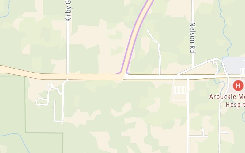
This location's approximate GPS Coordinates are 34.50631 x -97.01221.

Which directions can I travel from here?

From this junction, traffic can only enter going eastbound. Traffic can only exit going westbound.

On to US 177, about 4.1 miles away ►

Which direction are tolls charged here?

Tolls are not charged or collected at this junction.

View Map Travel Conditions

Closest Food, Gas, EV And Other Services Near SH 7 / to I–35

Use the map below for all services within about a two (2) mile radius.

Fuel, EV and convenience store header

Gas & EV Charging

Closest Gas Stations

FINISH LINE

2600 West Broadway Avenue • 0.53 miles

Store/Fuel Brand:

Phillips 66

SNAK SHAK WEST

1829 West Broadway Avenue • 1.09 miles

Store/Fuel Brand: Phillips 66

Shell

SHELL

1902 West Broadway Avenue • 1.14 miles

Store/Fuel Brand: Shell

CONOCO

1620 West Broadway Avenue • 1.33 miles

Store/Fuel Brand: Conoco

View Map

Closest EV Chargers

View Map

No EV charging stations nearby.

Coffee, snacks and dining header

Fast Food & Beverage

Closest Fast Food

Fast food refers ONLY to quick-service and take-out diners. All restaurant types are shown on the map below.

McDonald's

MCDONALD'S

2539 West Broadway Avenue • 0.55 miles

CARL'S JUNIOR

2104 West Broadway Avenue • 1.04 miles

GOLDEN CHICK

1906 West Broadway Avenue • 1.07 miles

TACO MAYO-SULPHUR-1900 W. BROADWAY

1900 West Broadway Avenue • 1.15 miles

Taco Bell

TACO BELL

1711 West Broadway Avenue • 1.30 miles

BRAUM'S

1526 West Broadway Avenue • 1.43 miles

SONIC

1322 West Broadway Avenue • 1.58 miles

View Map

Advertising
Advertising

Interactive POI Map

The interactive map and lists on this page include key traveler services in a two-mile radius, including gas stations, truck stops, EV charging facilities, fast-food or family restaurants, and hotels.

Current driving conditions and weather, may be found below.

Advertising
Advertising

Travel Conditions At SH 7 / to I–35

Current Weather And Visibility

  • 11 7 12
  • Clear

    59°F / 15°C

    Feels Like:

    56°F / 13.2°C

  • Visibility

    9 Mi / 14.5 Km

    3-Hour Precip:

    0 In / 0.0 Cm

  • South Southwest
    Winds (SSW)

    8.6 MPH / 13.9 KPH

    Gusts:

    14 MPH / 22.6 KPH

▸ Get the full forecast for This Location | The Oklahoma City area

Available Cameras

No camera feed …

There is no currently-available traffic camera feed for this location.

Advertising
Advertising

Pictures At SH 7 / to I–35

No photos …

There are no currently-available photos for this location.

Advertising
Advertising

Discover Oklahoma Attractions

Hotels and destinations header

Hotels & Airports

Destination Travel

Advertising
Advertising

EXPLORE OKLAHOMA

Journey to key destinations around and adjacent to Oklahoma!

Map Of This Region ▹

Communities in this metro area include Tulsa, Broken Arrow, Muskogee, Stillwater, Sapulpa, Vinita, Joplin, Missouri, Siloam Springs, Arkansas, and San Springs.

Individual toll maps for this region are listed below.

Map Of This Region ▹

Communities in this metro area include Stillwater and Tulsa.

Individual toll maps for this region are listed below.

Map Of This Region ▹

Communities in this metro area include Oklahoma City, Choctaw, Norman, Shawnee, Henryetta, Edmond, and Chickasha.

Individual toll maps for this region are listed below.

Map Of This Region ▹

Communities in this metro area include Lawton, Fort Sill, Geronimo, and Cache.

Individual toll maps for this region are listed below.

Map Of This Region ▹

Communities in this metro area include Dallas, Fort Worth, Plano, Addison, Frisco, Grand Prairie, Arlington, Carrrollton, and Lake Dallas.

Individual toll maps for this region are listed below.

Map Of This Region ▹

Communities in this metro area include Wichita, Bel Aire, Andover, Valley Center, and Maize.

Individual toll maps for this region are listed below.

Static map of Chickasaw Turnpike at SH 7 / to I–35

Static map. Interactive map is above.

Advertising
Advertising
Turnpikes.com is proud to partner with the following: