Share

Massachusetts Turnpike At I-95

Advertising
Advertising

This Location At A Glance

This is Exit 123 of the Massachusetts Turnpike.

This junction is located in Weston. NOTE: (Old Exit 14) WB On/EB Off.

This location is in the Boston area.

I-95
Map image © TomTom Intl BV

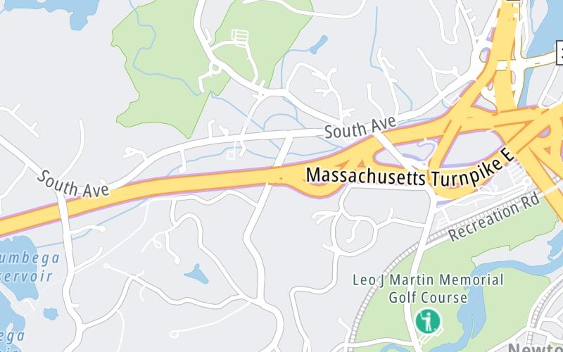
This location's approximate GPS Coordinates are 42.33883 x -71.27649.

Interactive Map Below


Which directions can I travel from here?

From this junction, traffic can only enter going westbound. Traffic can only exit going eastbound.

On to I-95, about 0.8 miles away ►

◄ Back to Natick Service Plaza Eastbound, about 5.0 miles away.

Nearby gas and food are shown on the interactive map below.

View Map

Weather & Visibility

  • 07 7 01
  • Clear

    F / -14°C

    Feels Like

    10°F / -12.3°C

  • Visibility

    12 Mi / 19.3 Km

    3 Hr Precip

    0 In / 0.0 Cm

  • W Wind

    2.3 Mi / 3.7 Km

    Gusts

    5.9 Mi / 9.6 Km


Available Cameras

I-90-EB-WESTON-EX 15 EAST MERGE

Camera direction: EAST. Boston 02493.
Source: MassDOT.

Camera direction: EAST. Boston 02493.<br />Source: MassDOT -

0.44 Mi

Camera direction: EAST. Boston 02493.<br />Source: MassDOT -

0.70 Mi

Camera direction: EAST. Boston 02493.<br />Source: MassDOT -

1.56 Mi

Camera direction: WEST. Boston 02493.<br />Source: MassDOT -

2.29 Mi

Camera direction: NORTH. Boston 02481.<br />Source: MassDOT -

2.66 Mi

Advertising

Closest Food, Gas, EV And Other Services Near I-95

The map shows traffic cameras and services in about a two-mile radius. Not all locations have cameras

Advertising

Discover Massachusetts Attractions

Hotels and destinations header

Hotels & Airports

Destination Travel

Advertising
Advertising

EXPLORE MASSACHUSETTS

Journey to key destinations around and adjacent to Massachusetts!

Map Of This Region ▹

Communities in this metro area include Boston, Cambridge, Chelsea, Allston, Framingham, Westborough, and Worcester.

Individual toll maps for this region are listed below.

Map Of This Region ▹

Communities in this metro area include Springfield, West Springfield, Chicopee, Westfield, and Hartford, Connecticut.

Individual toll maps for this region are listed below.

Map Of This Region ▹

Communities in this metro area include Hooksett, Concord, Manchester, and West Concord.

Individual toll maps for this region are listed below.

Map Of This Region ▹

Communities in this metro area include Albany, Schenectady, Rotterdam, Amsterdam, and West Stockbridge, Massachusetts.

Individual toll maps for this region are listed below.

Static map of Massachusetts Turnpike at I-95

Static map. Interactive map is above.

Advertising
Advertising
Turnpikes.com is proud to partner with the following: