San Mateo Traffic And Weather

Static map of San Mateo Hayward Bridge at Edgewater Blvd/Mariners Island Blvd

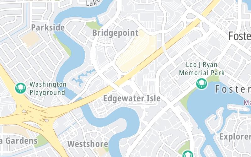
Right Now At Edgewater Blvd/Mariners Island Blvd and The San Mateo Hayward Bridge

Current Weather And Visibility

9:15 am Local Time

  • 09 7 04
  • Cloudy

    54°F / 12°C

    Feels Like:

    54°F / 12.5°C

  • Visibility

    10 Mi / 16.1 Km

    3-Hour Precip:

    0 In / 0.0 Cm

  • West
    Winds (W)

    3.9 MPH / 6.3 KPH

    Gusts:

    7.7 MPH / 12.4 KPH

Conditions and forecasts provided in partnership with AccuWeather.

AccuWeather logo

Weather provided in partnership with AccuWeather.

AccuWeather logo

Forecast weather and driving conditions follow the jump. These include an hour-by-hour forecast for the next 12-hours, a three-day forecast and an extended forecast, for extended travel planning.

An area traffic map, with available traffic cameras, shows driving conditions, from current traffic to mother nature's influence on the road. These follow the short-range forecasts below.

Driving Forecast Traffic Map

Advertising
Advertising

Driving Forecast For San Mateo, At Edgewater Blvd/Mariners Island Blvd

Next 12 Hours

9:15 am Local Time

Conditions and forecasts provided in partnership with AccuWeather.

AccuWeather logo

Weather provided in partnership with AccuWeather.

AccuWeather logo

Available Cameras

CA-92 @ VINTAGE PARK DR

CA-92 @ VINTAGE PARK DR

Camera Direction: EAST. Source: Caltrans - Berkeley 94404

Cameras Closest To Edgewater Blvd/Mariners Island Blvd

Camera Direction: EAST. Source: Caltrans - Berkeley 94404

0.36 Mi

Camera Direction: WEST. Source: Caltrans - Berkeley 94403

0.89 Mi

Camera Direction: NORTH. Source: Caltrans - Berkeley 94404

1.68 Mi

Camera Direction: EAST. Source: Caltrans - Berkeley 94404

3.42 Mi

Next Three (3) Days

Friday April 25

Friday forecast: Cloudy most of the time with a couple of showers, mainly early; breezy and cool

Showers

80% Chance Rain

60° F/15.6° C

W Wind

14 to 27 Mi/

22 to 43 Km

Sunrise

6:21 AM

Friday night: Cloudy most of the time with a couple of showers, mainly early; breezy and cool

Partly Cloudy W/ Showers

80% Chance Rain

47° F/8.3° C

WSW Wind

7 to 16 Mi/

11 to 26 Km

Sunset

7:54 PM

Saturday April 26

Saturday forecast: Times of clouds and sun with a couple of showers; breezy in the afternoon; there can be a rumble of thunder

Partly Sunny W/ Showers

84% Chance Rain

63° F/17.2° C

W Wind

12 to 28 Mi/

19 to 44 Km

Sunrise

6:20 AM

Saturday night: Times of clouds and sun with a couple of showers; breezy in the afternoon; there can be a rumble of thunder

Showers

59% Chance Rain

50° F/10.0° C

WSW Wind

9 to 21 Mi/

15 to 33 Km

Sunset

7:55 PM

Sunday April 27

Sunday forecast: Cool; low clouds in the morning with a passing shower followed by clouds giving way to some sun and breezy in the afternoon

Mostly Cloudy W/ Showers

56% Chance Rain

60° F/15.6° C

W Wind

13 to 27 Mi/

20 to 43 Km

Sunrise

6:19 AM

Sunday night: Cool; low clouds in the morning with a passing shower followed by clouds giving way to some sun and breezy in the afternoon

Partly Cloudy

4% Chance Rain

50° F/10.0° C

WSW Wind

6 to 16 Mi/

9 to 26 Km

Sunset

7:56 PM

Advertising
Advertising

Area Traffic Map

This junction is located in San Mateo, at GPS 37.55720 x -122.28354. Foster City is nearby. This location is in the San Francisco Bay Area area.

You can pan and zoom the interactive map. Select cameras to see the on-road traffic feeds, and pick exits or other markers for conditions at those locations.

Advertising
Advertising

Extended Forecast For San Mateo, At Edgewater Blvd/Mariners Island Blvd

Ten (10) Day Travel Planner

Go Online Before You Go On The Road!®

Conditions and forecasts provided in partnership with AccuWeather.

AccuWeather logo

Weather provided in partnership with AccuWeather.

AccuWeather logo
Advertising
Advertising

EXPLORE CALIFORNIA

Journey to key destinations around and adjacent to California!

Map Of This Region ▹

Communities in this metro area include Los Angeles, Long Beach, Irvine, San Juan Capistrano, and Santa Ana.

Individual toll maps for this region are listed below.

Map Of This Region ▹

Communities in this metro area include San Diego, Chula Vista, and Tijuana, Mexico.

Individual toll maps for this region are listed below.

Advertising
Advertising
Turnpikes.com is proud to partner with the following: