This is Exit 338 N of the Mackinac Bridge.
This junction is located in Mackinaw City. NOTE: No bridge access / NB off only.
This location is in the Eastern Upper Peninsula area; it also overlaps with the Northern Ontario area.
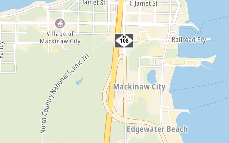
This location's approximate GPS Coordinates are 45.77654 x -84.73377.
Which directions can I travel from here?
From this junction, traffic can only exit going northbound.
On to E Jamet Street, about 0.5 miles away ►
◄ Back to US Hwy 23, about 0.1 miles away.
Which direction are tolls charged here?
Tolls are not charged or collected at this junction.
Use the map below for all services within about a two (2) mile radius.
Closest Gas Stations

SHELL
101 Jamet Street • 0.48 miles
Store/Fuel Brand: Shell

CITGO
14992 North Mackinaw Highway • 0.67 miles
Store/Fuel Brand: Citgo

MARATHON
308 South Nicolet Street • 834 feet
Store/Fuel Brand: Marathon
Closest EV Chargers
Closest Fast Food
Fast food refers ONLY to quick-service and take-out diners. All restaurant types are shown on the map below.
CJ'S GRUB STOP
168 South Huron Avenue • 0.41 miles

SUBWAY
222 East Central Avenue • 0.41 miles
DQ GRILL & CHILL
201 W Central Ave • 0.42 miles
SCALAWAGS WHITEFISH & CHIPS
226 East Central Avenue • 0.42 miles
DEVON'S MACKINAC ISLAND FUDGE CO.
205 East Central Avenue • 0.42 miles

KFC
225 East Central Avenue • 0.45 miles
MAMA MIA'S PIZZA
231 East Central Avenue • 0.46 miles
SULLY'S SWEET SHOP
317 East Central Avenue • 0.52 miles
The interactive map and lists on this page include key traveler services in a two-mile radius, including gas stations, truck stops, EV charging facilities, fast-food or family restaurants, and hotels.
Current driving conditions and weather, may be found below.

Mostly Cloudy
21°F / -6°C
Feels Like:
10°F / -12.4°C
Visibility
10 Mi / 16.1 Km
3-Hour Precip:
0 In / 0.0 Cm
West Northwest
Winds (WNW)
10.2 MPH / 16.4 KPH
Gusts:
15 MPH / 24.1 KPH
▸ Get the full forecast for This Location | The Eastern Upper Peninsula area
No camera feed …
There is no currently-available traffic camera feed for this location.
There are no currently-available photos for this location.
Destination Travel
Journey to key destinations around and adjacent to Michigan!
Communities in this metro area include Detroit, Grosse Ile, Ann Arbor, Pontiac, and Lansing.
Individual toll maps for this region are listed below.
Communities in this metro area include St Ignace and Sault Ste Marie.
Individual toll maps for this region are listed below.
Communities in this metro area include Port Huron, Flint, Saginaw, and Bay City.
Individual toll maps for this region are listed below.
Communities in this metro area include Toledo, Perrysburg, Maumee, Montpelier, and Wauseon.
Individual toll maps for this region are listed below.
Communities in this metro area include Sault Ste Marie, Thunder Bay, Fort Frances, and Greater Sudbury.
Individual toll maps for this region are listed below.
Communities in this metro area include Windsor.
Individual toll maps for this region are listed below.