John F Kennedy Memorial Bridge At US 31 / West Court Ave

Advertising
Advertising

Map & services within two (2) miles

Interactive map shows available cameras, plus nearby fuel, food and lodging

See below for more about this area

Advertising
Advertising

About This Location

US 31 / West Court Ave
Photo by Turnpikes.com

At A Glance

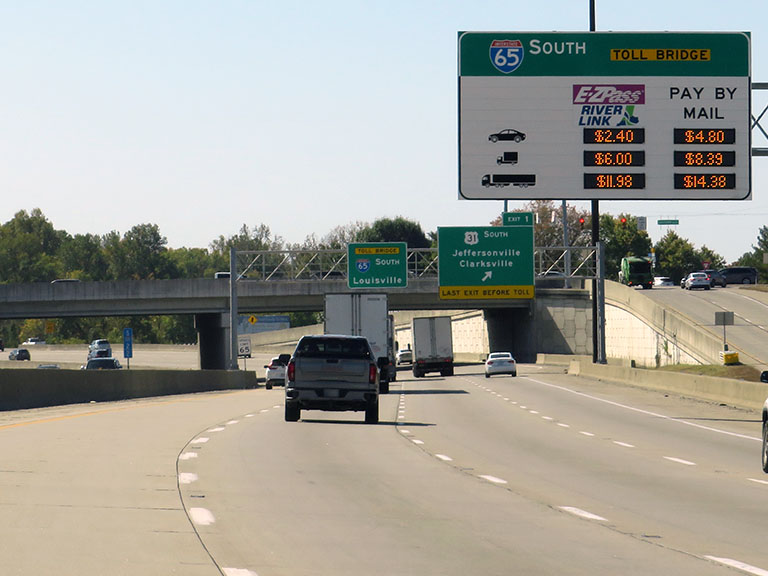
This is Exit 1 of the John F Kennedy Memorial Bridge.

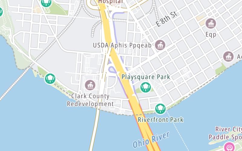
This junction is located in Jeffersonville. NOTE: Jeffersonville, IN.

This location is in the Louisville - Southern Indiana area.

Interactive Map Above

This location's approximate GPS Coordinates are 38.27194 x -85.74731.

Which directions can I travel from here?

From this junction, traffic can only enter going southbound. Traffic can only exit going southbound.

On to JFK Memorial Bridge Tolls, about 0.3 miles away ►

This location also connects with Indiana.

Which direction are tolls charged here?

  • ▸ Southbound on ramp
  • ▸ Southbound off ramp

View Map Travel Conditions


Using The POI Map

The interactive map and lists on this page include key traveler services within two miles of this destination point.

You will find common services, including gas stations, truck stops, EV charging facilities, fast-food or family restaurants, and hotels. These are displayed on the interactive map as markers, which you can select for more information.

Current driving conditions and weather, along with a more complete list of key services, may be found below the map.

View Map Weather

Static map of John F Kennedy Memorial Bridge at US 31 / West Court Ave
Static map. Interactive map is above.
Advertising
Advertising

Travel Conditions At US 31 / West Court Ave

Current Weather And Visibility

  • 07 7 09
  • Clear

    69°F / 20.4°C

    Feels Like:

    70°F / 20.9°C

  • Visibility

    9 Mi / 14.5 Km

    3-Hour Precip:

    0 In / 0.0 Cm

  • Northeast
    Winds (NE)

    0.6 MPH / 1 KPH

    Gusts:

    1.8 MPH / 3 KPH

▸ Get the full forecast for This Location | The Louisville - Southern Indiana area

Available Cameras

I-65 @ LINCOLN & KENNEDY

I-65 @ LINCOLN & KENNEDY

Camera Direction: NORTH. Source: INDOT - Jeffersonville 47130

Cameras Closest To US 31 / West Court Ave

Camera Direction: NORTH. Source: INDOT - Jeffersonville 47130

0.24 Mi

Camera Direction: NORTH. Source: INDOT - Jeffersonville 47130

0.27 Mi

Camera Direction: UNKNOWN. Source: TRIMARC - undetermined 47130

0.36 Mi

Camera Direction: UNKNOWN. Source: TRIMARC - undetermined 47130

0.36 Mi

Camera Direction: NORTH. Source: TRIMARC - Louisville 40202

0.45 Mi

Advertising
Advertising

Travel Pictures

Pictures Around US 31 / West Court Ave

About this photo:
An electronic toll sign alerts drivers going southbound on I-65 to toll charges ahead at the JFK Memorial Bridge, if they do not exit at US 31, which is also the exit for Court Avenue in Jeffersonville, Indiana.

Photo taken 10-14-2022

More Pictures Near US 31 / West Court Ave

Photo taken 10-14-2022
Advertising
Advertising

Closest Food, Gas, EV And Other Services Near US 31 / West Court Ave

The map above shows all services within about a two (2) mile radius.

Hotels and destinations header

Hotels & Airports

Destination Travel

Fuel, EV and convenience store header

Gas & EV Charging

Closest Gas Stations

THORNTONS

202 East 10th Street • 0.57 miles

Store/Fuel Brand: Thorntons

LOUISVILLE METRO

900 Marriott Drive • 0.62 miles

Store/Fuel Brand:

Shell

SHELL

300 South 1st Street • 1.34 miles

Store/Fuel Brand: Shell

Marathon

MARATHON

1317 East 10th Street • 1.40 miles

Store/Fuel Brand: Marathon

View Map

Closest EV Chargers

Blink

CHESTNUT STREET PARKING LOT/ YOUTH SHELTER LOT

118 East Chestnut Street • 0.42 miles

WITHERSPOON GARAGE

101 Witherspoon Street • 0.97 miles

ChargePoint

CHARGEPOINT

315 East Main Street • 1.13 miles

ChargePoint

CHARGEPOINT

220 West Main Street • 1.15 miles

View Map

Coffee, snacks and dining header

Fast Food & Beverage

Closest Fast Food

Fast food refers ONLY to quick-service and take-out diners. All restaurant types are shown on the map above.

PAPU CHOS

246 Spring Street • 0.40 miles

Jimmy John's

JIMMY JOHN'S

921 Gateway Dr • 0.45 miles

Wingstop

WINGSTOP

• 0.45 miles

TACOS CELESTE

129 East Market Street • 0.46 miles

BRITIFF ENTERPRISES

201 East Market Street • 0.49 miles

DQ GRILL & CHILL

213 East 10th Street • 0.59 miles

ORANGE CLOVER KITCHEN & MORE

Quartz Road • 1,221 feet

ADRIENNE & CO BAKERY CAFE

129 West Court Avenue • 1,389 feet

View Map

Discover Kentucky Attractions

Advertising
Advertising

EXPLORE KENTUCKY

Journey to key destinations around and adjacent to Kentucky!

Map Of This Region ▹

Communities in this metro area include Louisville and Jeffersonville, Indiana.

Individual toll maps for this region are listed below.

Map Of This Region ▹

Communities in this metro area include Cincinnati, Norwood, Cheviot, Northbrook, Reading, Covington, Kentucky, and Newport, Kentucky.

Individual toll maps for this region are listed below.

cincinnati-covington

Roads Within Region

Map Of This Region ▹

Advertising
Advertising
Turnpikes.com is proud to partner with the following: