CA 261 At I-5 Via Jamboree Rd

Advertising
Advertising

Map & services within two (2) miles

Interactive map shows available cameras, plus nearby fuel, food and lodging

See below for more about this area

Advertising
Advertising

About This Location

I-5 via Jamboree Rd

At A Glance

This junction is located in Irvine. NOTE: NB off / SB on only.

This location is in the Greater Los Angeles area.

Interactive Map Above

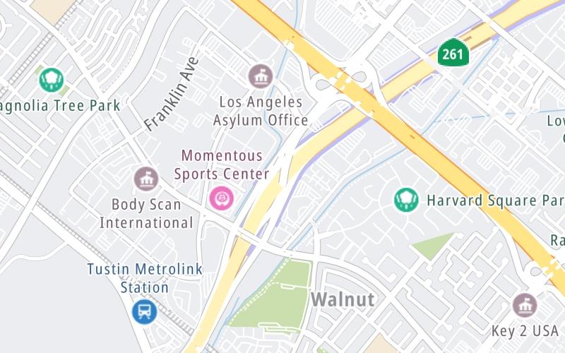
This location's approximate GPS Coordinates are 33.71472 x -117.79865.

Which directions can I travel from here?

From this junction, traffic can only enter going southbound. Traffic can only exit going northbound.

On to Irvine Boulevard, about 1.2 miles away ►

◄ Back to Walnut Ave, about 0.5 miles away.

Which direction are tolls charged here?

Tolls are not charged or collected at this junction.

View Map Travel Conditions

Above: Map image © TomTom Intl BV

Using The POI Map

The interactive map and lists on this page include key traveler services within two miles of this destination point.

You will find common services, including gas stations, truck stops, EV charging facilities, fast-food or family restaurants, and hotels. These are displayed on the interactive map as markers, which you can select for more information.

Current driving conditions and weather, along with a more complete list of key services, may be found below the map.

View Map Weather

Static map of Ca 261 at I-5 via Jamboree Rd
Static map. Interactive map is above.
Advertising
Advertising

Travel Conditions At I-5 via Jamboree Rd

Current Weather And Visibility

  • 08 7 04
  • Cloudy

    58°F / 14.5°C

    Feels Like:

    59°F / 15.3°C

  • Visibility

    10 Mi / 16.1 Km

    3-Hour Precip:

    0 In / 0.0 Cm

  • South
    Winds (S)

    1.6 MPH / 2.6 KPH

    Gusts:

    3.8 MPH / 6.1 KPH

▸ Get the full forecast for This Location | The Greater Los Angeles area

Available Cameras

CA-261 @ IRVINE BLVD

CA-261 @ IRVINE BLVD

Camera Direction: NORTH. Source: Caltrans - Los Angeles 92602

Cameras Closest To I-5 via Jamboree Rd

Camera Direction: NORTH. Source: Caltrans - Los Angeles 92602

1.31 Mi

Camera Direction: NORTH. Source: Caltrans - Los Angeles 92602

1.77 Mi

Camera Direction: NORTH. Source: Caltrans - Los Angeles 92780

2.41 Mi

Camera Direction: NORTH. Source: Caltrans - Los Angeles 92602

2.54 Mi

Camera Direction: NORTH. Source: Caltrans - Los Angeles 92602

3.07 Mi

Advertising
Advertising

Travel Pictures

No photos …

There are no currently-available photos for this location.

Advertising
Advertising

Closest Food, Gas, EV And Other Services Near I-5 via Jamboree Rd

The map above shows all services within about a two (2) mile radius.

Hotels and destinations header

Hotels & Airports

Destination Travel

Fuel, EV and convenience store header

Gas & EV Charging

Closest Gas Stations

View Map

No gas or other fuel stations nearby.

Closest EV Chargers

View Map

No EV charging stations nearby.

Coffee, snacks and dining header

Fast Food & Beverage

Closest Fast Food

Fast food refers ONLY to quick-service and take-out diners. All restaurant types are shown on the map above.

View Map

No fast-food dining nearby.

Discover California Attractions

Advertising
Advertising

EXPLORE CALIFORNIA

Journey to key destinations around and adjacent to California!

Map Of This Region ▹

Communities in this metro area include Los Angeles, Long Beach, Irvine, San Juan Capistrano, and Santa Ana.

Individual toll maps for this region are listed below.

Map Of This Region ▹

Communities in this metro area include San Diego, Chula Vista, and Tijuana, Mexico.

Individual toll maps for this region are listed below.

Advertising
Advertising
Turnpikes.com is proud to partner with the following: