Share

Adams Avenue Parkway At I–84 / To I–15 / US 89

Advertising
Advertising

About This Location

I–84 / to I–15 / US 89
Map image © TomTom Intl BV

At A Glance

This junction is located in South Weber. Washington Terrace is nearby.

Interactive Map Below

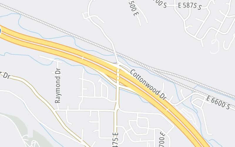
This location's approximate GPS Coordinates are 41.15025 x -111.96894.

Which directions can I travel from here?

From this junction, traffic can enter traveling both southbound and northbound. Traffic can also exit traveling both southbound and northbound.

On to AAP Toll Plaza, about 0.4 miles away ►

Which direction are tolls charged here?

Tolls are not charged or collected at this junction.

View Map Travel Conditions

Closest Food, Gas, EV And Other Services Near I–84 / to I–15 / US 89

Use the map below for all services within about a two (2) mile radius.

Fuel, EV and convenience store header

Gas & EV Charging

Closest Gas Stations

SINCLAIR

925 Chambers Street • 1.25 miles

Store/Fuel Brand: Sinclair

MAVERIK

5153 South 500 East • 1.37 miles

Store/Fuel Brand: Maverik

7-Eleven

7-ELEVEN

5691 Harrison Boulevard • 1.63 miles

Store/Fuel Brand: 7-Eleven

View Map

Closest EV Chargers

ChargePoint

CHARGEPOINT

5782 Adams Avenue Parkway • 0.58 miles

ChargePoint

CHARGEPOINT

5782 Adams Avenue Parkway • 0.60 miles

ChargePoint

CHARGEPOINT

5568 South 500 East • 0.89 miles

Blink

GOLDENWEST CREDIT UNION

5025 Adams Avenue • 1.53 miles

View Map

Coffee, snacks and dining header

Fast Food & Beverage

Closest Fast Food

Fast food refers ONLY to quick-service and take-out diners. All restaurant types are shown on the map below.

ARCTIC CIRCLE OGDEN

929 Chambers Street • 1.25 miles

KAFFE MERCANTILE

930 Chambers Street • 1.30 miles

PAPA MURPHY'S DELIVERY

5695 Harrison Boulevard • 1.56 miles

McDonald's

MCDONALD'S

5745 Harrison Boulevard • 1.61 miles

Jimmy John's

JIMMY JOHN'S

1657 East Skyline Drive • 1.62 miles

COSTA VIDA

1657 East Skyline Drive • 1.63 miles

Wendy's

WENDY'S

5710 Harrison Boulevard • 1.66 miles

Domino's

DOMINO'S

1735 East Skyline Drive • 1.68 miles

View Map

Advertising
Advertising

Interactive POI Map

The interactive map and lists on this page include key traveler services in a two-mile radius, including gas stations, truck stops, EV charging facilities, fast-food or family restaurants, and hotels.

Current driving conditions and weather, may be found below.

Advertising
Advertising

Travel Conditions At I–84 / to I–15 / US 89

Current Weather And Visibility

  • 10 7 12
  • Partly Cloudy

    38°F / 3.5°C

    Feels Like:

    39°F / 4.1°C

  • Visibility

    10 Mi / 16.1 Km

    3-Hour Precip:

    0 In / 0.0 Cm

  • East
    Winds (E)

    3 MPH / 4.8 KPH

    Gusts:

    4 MPH / 6.5 KPH

▸ Get the full forecast for This Location

Available Cameras

No camera feed …

There is no currently-available traffic camera feed for this location.

Advertising
Advertising

Pictures At I–84 / to I–15 / US 89

No photos …

There are no currently-available photos for this location.

Advertising
Advertising

Discover Utah Attractions

Hotels and destinations header

Hotels & Airports

Destination Travel

Advertising
Advertising

EXPLORE UTAH

Journey to key destinations around and adjacent to Utah!

Map Of This Region ▹

Communities in this metro area include Washington Terrace, South Weber, and South Ogden.

Individual toll maps for this region are listed below.

Static map of Adams Avenue Parkway at I–84 / to I–15 / US 89

Static map. Interactive map is above.

Advertising
Advertising
Turnpikes.com is proud to partner with the following: