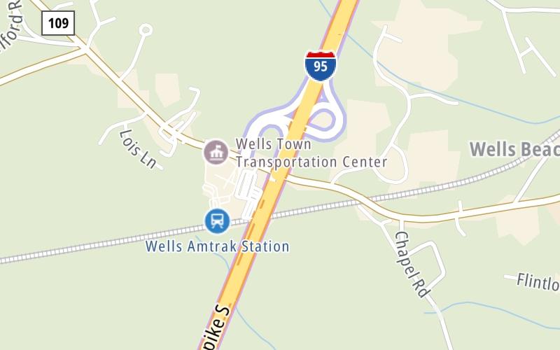
12:03 am Local Time
Cloudy
48°F / 9°C
Feels Like
51°F / 10.6°C
Visibility
9 Mi / 14.5 Km
3 Hr Precip
0.01 In / 0.0 Cm
NNE Wind
0.6 Mi / 1 Km
Gusts
2.7 Mi / 4.3 Km
An area traffic map, with available traffic cameras, shows driving conditions, from current traffic to mother nature's influence on the road. These follow the short-range forecasts below.
Wednesday forecast: Cooler with rain and drizzle

Rain
98% Chance Rain
54° F/12.2° C
ESE Wind
5 to 13 Mi/
7 to 20 Km
Sunrise
5:20 AM
Wednesday night: Periods of rain

Rain
91% Chance Rain
47° F/8.3° C
SSE Wind
6 to 8 Mi/
9 to 13 Km
Sunset
7:57 PM
Thursday forecast: Periods of rain; wet roads and lower visibility may lead to travel disruptions

Rain
99% Chance Rain
55° F/12.8° C
E Wind
9 to 17 Mi/
15 to 28 Km
Sunrise
5:19 AM
Thursday night: Periods of rain

Rain
99% Chance Rain
48° F/8.9° C
NE Wind
7 to 17 Mi/
11 to 28 Km
Sunset
7:58 PM
Friday forecast: Periods of rain

Rain
91% Chance Rain
54° F/12.2° C
E Wind
8 to 16 Mi/
13 to 26 Km
Sunrise
5:18 AM
Friday night: Partly cloudy

Intermittent Clouds
17% Chance Rain
46° F/7.8° C
SW Wind
7 to 13 Mi/
11 to 20 Km
Sunset
7:59 PM
This junction is located in Wells, at GPS 43.32280 x -70.60827. Sanford is nearby.
You can pan and zoom the interactive map. Select cameras to see the on-road traffic feeds, and pick exits or other markers for conditions at those locations.
Journey to key destinations around and adjacent to Maine!
Communities in this metro area include Portland, Scarborough, and Biddeford.
Individual toll maps for this region are listed below.
Communities in this metro area include Augusta, Gardiner, Farmingdale, and Manchester.
Individual toll maps for this region are listed below.
Communities in this metro area include Portsmouth, Dover, Durham, Rochester, Kittery, Maine, and York, Maine.
Individual toll maps for this region are listed below.