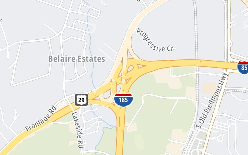
This is Exit 14A/14B of the Southern Connector.
This junction is located in Greenville. NOTE: N to Spartanburg / S to Atlanta.
This location is in the Greenville - Spartanburg area.
This location's approximate GPS Coordinates are 34.78990 x -82.43907.
Which directions can I travel from here?
From this junction, traffic can enter traveling both southbound and northbound. Traffic can also exit traveling both southbound and northbound.
On to White Horse Road, about 1.3 miles away ►
◄ Back to Brown Road, about 2.0 miles away.
Which direction are tolls charged here?
Tolls are not charged or collected at this junction.
Use the map below for all services within about a two (2) mile radius.
Closest Gas Stations

QUIKTRIP
1509 Grove Road • 1.13 miles
Store/Fuel Brand: QuikTrip

BP
1631 White Horse Road • 1.15 miles
Store/Fuel Brand: BP

CITGO
1706 White Horse Road • 1.19 miles
Store/Fuel Brand: Citgo

PIEDMONT BP
2900 Highway 153 • 1.68 miles
Store/Fuel Brand: BP
Closest EV Chargers
No EV charging stations nearby.
Closest Fast Food
Fast food refers ONLY to quick-service and take-out diners. All restaurant types are shown on the map below.
PETEE'S DRIVE IN
1785 White Horse Road • 1.08 miles
R D COCHRAN STORE
1510 Grove Road • 1.11 miles

MCDONALD'S
1706 White Horse Road • 1.21 miles

SUBWAY
1519 White Horse Road • 1.28 miles

DOMINO'S
3031 White Horse Road • 1.57 miles
HUNT BROTHERS PIZZA
2900 Highway 153 • 1.67 miles
The interactive map and lists on this page include key traveler services in a two-mile radius, including gas stations, truck stops, EV charging facilities, fast-food or family restaurants, and hotels.
Current driving conditions and weather, may be found below.

Cloudy
59°F / 15°C
Feels Like:
63°F / 17°C
Visibility
9 Mi / 14.5 Km
3-Hour Precip:
0 In / 0.0 Cm
East
Winds (E)
2.7 MPH / 4.3 KPH
Gusts:
5 MPH / 8 KPH
▸ Get the full forecast for This Location | The Greenville - Spartanburg area
No camera feed …
There is no currently-available traffic camera feed for this location.
There are no currently-available photos for this location.
Destination Travel
Journey to key destinations around and adjacent to South Carolina!
Communities in this metro area include Greenville, Spartanburg, Piedmont, Simpsonville, Anderson, and Asheville, North Carolina.
Individual toll maps for this region are listed below.
Communities in this metro area include Columbia, West Columbia, Forest Acres, Orangeburg, Sumter, and Newberry.
Individual toll maps for this region are listed below.
Roads Within Region
Communities in this metro area include Myrtle Beach, Carolina Forest, Arcadian Shores, North Myrtle Beach, Surfside Beach, and Murrells Inlet.
Individual toll maps for this region are listed below.
Roads Within Region
Communities in this metro area include Charleston, Isle Of Palms, Kiawah Island, Johns Island, Folly Beach, North Charleston, and Goose Creek.
Individual toll maps for this region are listed below.
Roads Within Region
Communities in this metro area include Charlotte, Wesley Chapel, Monroe, Unionville, and Fairview.
Individual toll maps for this region are listed below.