Interactive map shows available cameras, plus nearby fuel, food and lodging
See below for more about this area
This is Exit 4 of the Blue Star Turnpike.
This junction is located in Portsmouth. NOTE: SB On/NB Off.
This location is in the Portsmouth - Dover area.
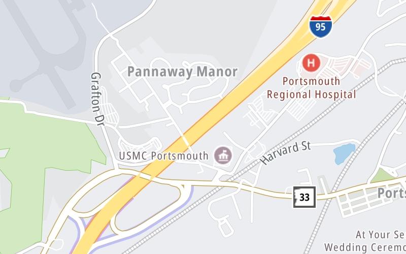
This location's approximate GPS Coordinates are 43.06105 x -70.79939.
Which directions can I travel from here?
From this junction, traffic can only enter going southbound. Traffic can only exit going northbound.
On to US 1 Alt, about 0.4 miles away ►
◄ Back to Grafton Road, about 0.3 miles away.
▹ The Blue Star Turnpike and the Spaulding Turnpike connect here.
Which direction are tolls charged here?
Tolls are not charged or collected at this junction.
Above: Map image © TomTom Intl BVThe interactive map and lists on this page include key traveler services within two miles of this destination point.
You will find common services, including gas stations, truck stops, EV charging facilities, fast-food or family restaurants, and hotels. These are displayed on the interactive map as markers, which you can select for more information.
Current driving conditions and weather, along with a more complete list of key services, may be found below the map.
Static map. Interactive map is above.Partly Sunny
63°F / 17.4°C
Feels Like:
63°F / 17.4°C
Visibility
16 Mi / 25.7 Km
3-Hour Precip:
0 In / 0.0 Cm
West
Winds (W)
8.5 MPH / 13.7 KPH
Gusts:
20.8 MPH / 33.5 KPH
▸ Get the full forecast for This Location | The Portsmouth - Dover area
There are no currently-available photos for this location.
The map above shows all services within about a two (2) mile radius.
Destination Travel
Closest Gas Stations
EXIT 3 TRAVEL STOP
1166 Greenland Road • 0.80 miles
Store/Fuel Brand:
U-HAUL
400 US Highway 1 Bypass • 1.21 miles
Store/Fuel Brand:
AMPET
921 Islington Street • 1.36 miles
Store/Fuel Brand:
LAFAYETTE ROAD SUNOCO
766 Lafayette Road • 1.55 miles
Store/Fuel Brand: Sunoco
Closest EV Chargers
CHARGEPOINT
333 Borthwick Avenue • 0.53 miles
CONNECTOR: IEC62196Type1
POWER: 6 KW @ 240 V
CURRENT: 27 Amp AC1
CHARGEPOINT
200 Grafton Drive • 0.77 miles
CONNECTOR: IEC62196Type1
POWER: 6 KW @ 240 V
CURRENT: 27 Amp AC1
CHARGEPOINT
94 Coakley Road • 0.98 miles
CONNECTOR: IEC62196Type1
POWER: 6 KW @ 240 V
CURRENT: 27 Amp AC1
PORT INN
505 US Highway 1 Bypass • 1.19 miles
CONNECTOR: Tesla
POWER: 7 KW @ 240 V
CURRENT: 30 Amp AC1
Closest Fast Food
Fast food refers ONLY to quick-service and take-out diners. All restaurant types are shown on the map above.
MCDONALD'S
63 Ocean Road • 1.49 miles
MCDONALD'S
1000 Lafayette Road • 1.62 miles
FIVE GUYS
1390 Lafayette Road • 1.71 miles
Journey to key destinations around and adjacent to New Hampshire!
Communities in this metro area include Hooksett, Concord, Manchester, and West Concord.
Individual toll maps for this region are listed below.
Communities in this metro area include Portsmouth, Dover, Durham, Rochester, Kittery, Maine, and York, Maine.
Individual toll maps for this region are listed below.