This junction is located in Fort Frances. NOTE: Access point to United States.
This location is in the Northeast Minnesota area.
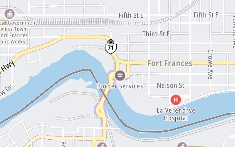
This location's approximate GPS Coordinates are 48.60899 x -93.40022.
Which directions can I travel from here?
From this junction, traffic can enter traveling both southbound and northbound. Traffic can also exit traveling both southbound and northbound.
◄ Back to Canada Border Services, about 0.0 miles away.
This location also connects with Ontario.
Which direction are tolls charged here?
Tolls are not charged or collected at this junction.
Use the map below for all services within about a two (2) mile radius.
Closest Gas Stations
SAFEWAY
417 Scott Street • 0.47 miles
Store/Fuel Brand: Safeway
CENEX
520 3rd Street • 0.54 miles
Store/Fuel Brand: Cenex
BOOTLEGGERS FUEL & LIQUORS
401 3rd Avenue • 0.54 miles
Store/Fuel Brand:

BP
301 4th Street • 0.55 miles
Store/Fuel Brand: BP
Closest EV Chargers
Closest Fast Food
Fast food refers ONLY to quick-service and take-out diners. All restaurant types are shown on the map above.

SUBWAY RAINY LAKE PLAZA
540 King's Hwy • 0.72 miles

DOMINO'S
283 Scott Street • 1,027 feet
PIZZA PIZZA
297 Scott Street • 1,067 feet
KRISPY KRUNCHY CHICKEN
1100 3rd Avenue • 1.04 miles

PFK
860 King's Highway • 1.12 miles

MCDONALD'S
831 King's Highway • 1.13 miles
DQ GRILL & CHILL
1306 3rd Avenue • 1.15 miles
DQ GRILL & CHILL
982 King's Highway • 1.18 miles
The interactive map and lists on this page include key traveler services in a two-mile radius, including gas stations, truck stops, EV charging facilities, fast-food or family restaurants, and hotels.
Current driving conditions and weather, may be found below.

Sunny
31°F / -0.6°C
Feels Like:
38°F / 3.5°C
Visibility
13 Mi / 20.9 Km
3-Hour Precip:
0 In / 0.0 Cm
East Northeast
Winds (ENE)
1.2 MPH / 2 KPH
Gusts:
3.5 MPH / 5.6 KPH
▸ Get the full forecast for This Location | The Northeast Minnesota area
No camera feed …
There is no currently-available traffic camera feed for this location.
There are no currently-available photos for this location.
Destination Travel
Journey to key destinations around and adjacent to Minnesota!
Communities in this metro area include Duluth and International Falls.
Individual toll maps for this region are listed below.
Communities in this metro area include Minneapolis, St Paul, Brooklyn Park, and Maple Grove.
Individual toll maps for this region are listed below.
Roads Within Region
Communities in this metro area include Sault Ste Marie, Thunder Bay, Fort Frances, and Greater Sudbury.
Individual toll maps for this region are listed below.