Share

International Bridge At US Customs

Advertising
Advertising

About This Location

US Customs
Map image © TomTom Intl BV

At A Glance

This junction is located in International Falls. NOTE: Customs and Border Protection checkpoint.

This location is in the Northeast Minnesota area.

Interactive Map Below

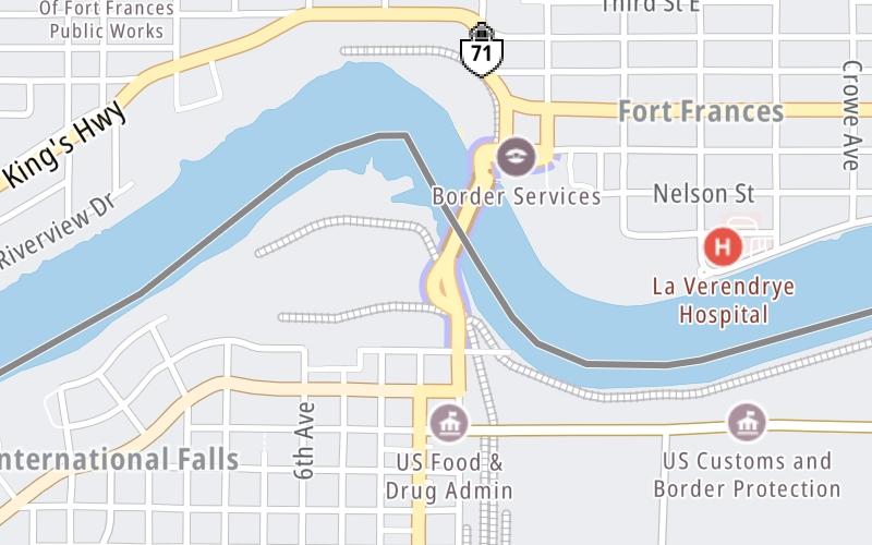
This location's approximate GPS Coordinates are 48.60578 x -93.40298.

Which directions can I travel from here?

From this junction, traffic can only enter going southbound. Traffic can only exit going southbound.

On to United States / Canada Border, about 0.2 miles away ►

◄ Back to International Bridge Tolls, about 0.0 miles away.

Which direction are tolls charged here?

Tolls are not charged or collected at this junction.

View Map Travel Conditions

Advertising
Advertising

Interactive POI Map

The interactive map will help you orient this location in relationship to other junctions.

Current driving conditions and weather may be found below.

Advertising
Advertising

Travel Conditions At US Customs

Current Weather And Visibility

  • 02 7 12
  • Mostly Clear

    -10°F / -23.1°C

    Feels Like:

    -19°F / -28.5°C

  • Visibility

    9 Mi / 14.5 Km

    3-Hour Precip:

    0 In / 0.0 Cm

  • West
    Winds (W)

    6.9 MPH / 11.1 KPH

    Gusts:

    14.6 MPH / 23.5 KPH

▸ Get the full forecast for the Northeast Minnesota area

Available Cameras

No camera feed …

There is no currently-available traffic camera feed for this location.

Advertising
Advertising

Pictures At US Customs

No photos …

There are no currently-available photos for this location.

Advertising
Advertising

Discover Minnesota Attractions

Hotels and destinations header

Hotels & Airports

Destination Travel

Advertising
Advertising

EXPLORE MINNESOTA

Journey to key destinations around and adjacent to Minnesota!

Map Of This Region ▹

Communities in this metro area include Duluth and International Falls.

Individual toll maps for this region are listed below.

Map Of This Region ▹

Communities in this metro area include Minneapolis, St Paul, Brooklyn Park, and Maple Grove.

Individual toll maps for this region are listed below.

twin cities metro

Roads Within Region

Map Of This Region ▹

Map Of This Region ▹

Communities in this metro area include Sault Ste Marie, Thunder Bay, Fort Frances, and Greater Sudbury.

Individual toll maps for this region are listed below.

Static map of International Bridge at US Customs

Static map. Interactive map is above.

Advertising
Advertising
Turnpikes.com is proud to partner with the following: