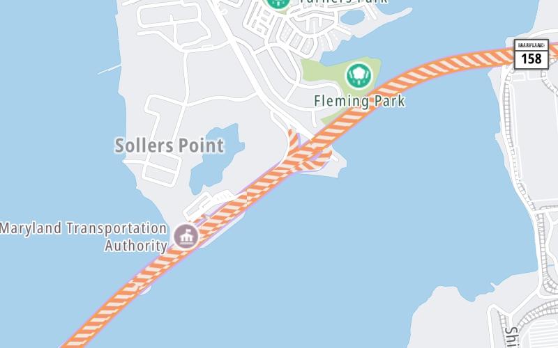
This is Exit 44 of the Francis Scott Key Bridge.
This junction is located in Dundalk.
This location is in the Baltimore area.
This location's approximate GPS Coordinates are 39.23204 x -76.50678.
Which directions can I travel from here?
From this junction, traffic can only enter going southbound. Traffic can only exit going northbound.
On to Bethlehem Blvd / Peninsula Expressway, about 1.6 miles away ►
◄ Back to MD 173/Hawkins Point Rd, about 3.9 miles away.
Which direction are tolls charged here?
Tolls are not charged or collected at this junction.
Above: Map image © TomTom Intl BVThe interactive map and lists on this page include key traveler services within two miles of this destination point.
You will find common services, including gas stations, truck stops, EV charging facilities, fast-food or family restaurants, and hotels. These are displayed on the interactive map as markers, which you can select for more information.
Current driving conditions and weather, along with a more complete list of key services, may be found below the map.
The interactive map shows dining and services near your chosen location: Broening Highway and the Francis Scott Key Bridge. A detailed summary of food and services around here is shown after the map.
Pan and zoom the map as you desire, and select markers for information and other options, including online ordering, where available.
Cloudy
31°F / -0.6°C
Feels Like:
22°F / -5.3°C
Visibility
4 Mi / 6.4 Km
3-Hour Precip:
0 In / 0.0 Cm
East Northeast
Winds (ENE)
8.1 MPH / 13 KPH
Gusts:
8.1 MPH / 13 KPH
▸ Get the full forecast for This Location | The Baltimore area
Closest Gas Stations
HIGH'S DAIRY STORE
6801 Broening Road • 1.45 miles
Store/Fuel Brand: High's
Closest EV Chargers
325 SOLLERS POINT ROAD
325 Sollers Point Road • 0.81 miles
CONNECTOR: Chademo
POWER: 50 KW @ 400 V
CURRENT: 125 Amp DC
BGE-SOLLERS POINT
325 Sollers Point Road • 0.85 miles
CONNECTOR: Chademo
POWER: 50 KW @ 400 V
CURRENT: 125 Amp DC
INDEPENDENT OPERATORS
325 Sollers Point Road • 0.85 miles
CONNECTOR: IEC62196Type1CCS
POWER: 50 KW @ 400 V
CURRENT: 125 Amp DC
TPA MAIN OFFICE
6995 Bethlehem Boulevard • 1.61 miles
CONNECTOR: IEC62196Type1
POWER: 6 KW @ 208 V
CURRENT: 30 Amp AC1
Closest Fast Food
Fast food refers ONLY to quick-service and take-out diners. All restaurant types are shown on the map below.
HARVEY'S
3435 Dundalk Avenue • 1.33 miles
Select/Tap Vendors For Info
Vendors within about two miles of Broening Highway and the Francis Scott Key Bridge are listed, sorted by distance, with the closest displayed on top. Select/tap the vendor name to show address, phone numbers and available URLs for gas stations, EV charging stations and fast-food dining. Links will open in a new window. Turnpikes.com is not responsible for third-party website content.
HIGH'S DAIRY STORE
• 1.45 miles
325 SOLLERS POINT ROAD
• 0.81 miles
BGE-SOLLERS POINT
• 0.85 miles
INDEPENDENT OPERATORS
• 0.85 miles
TPA MAIN OFFICE
• 1.61 miles
This list only includes quick-service and take-out restaurants. All nearby restaurants are shown on the map above.
HARVEY'S
• 1.33 miles
Journey to key destinations around and adjacent to Maryland!
Communities in this metro area include Baltimore, Edgewood, Columbia, Laurel, and Gaithersburg.
Individual toll maps for this region are listed below.
Communities in this metro area include Washington, Dc, Fairfax County, Virginia, Loundoun County, Virginia, Montgomery County, Maryland, and Prince George's County, Maryland.
Individual toll maps for this region are listed below.
Communities in this metro area include Wilmington, Middletown, Newark, and Carneys Point, New Jersey.
Individual toll maps for this region are listed below.