Share

Francis Scott Key Bridge At Broening Highway

Advertising
Advertising

About This Location

Broening Highway
Map image © TomTom Intl BV

At A Glance

This is Exit 44 of the Francis Scott Key Bridge.

This junction is located in Dundalk.

This location is in the Baltimore area.

Interactive Map Below

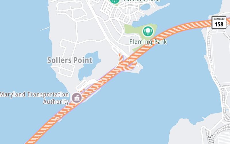
This location's approximate GPS Coordinates are 39.23204 x -76.50678.

Which directions can I travel from here?

From this junction, traffic can only enter going southbound. Traffic can only exit going northbound.

On to Bethlehem Blvd / Peninsula Expressway, about 1.6 miles away ►

◄ Back to MD 173/Hawkins Point Rd, about 3.9 miles away.

Which direction are tolls charged here?

Tolls are not charged or collected at this junction.

View Map Travel Conditions

Closest Food, Gas, EV And Other Services Near Broening Highway

Use the map below for all services within about a two (2) mile radius.

Fuel, EV and convenience store header

Gas & EV Charging

Closest Gas Stations

CARROLL MOTOR FUELS

6801 Broening Road • 1.47 miles

Store/Fuel Brand: Carroll

View Map

Closest EV Chargers

325 SOLLERS POINT ROAD

325 Sollers Point Road • 0.81 miles

View Map

Coffee, snacks and dining header

Fast Food & Beverage

Closest Fast Food

Fast food refers ONLY to quick-service and take-out diners. All restaurant types are shown on the map below.

POINT CORNER CARRY OUT

423 Sollers Point Road • 0.89 miles

FARMER'S FRIDGE

• 1.62 miles

View Map

Advertising
Advertising

Interactive POI Map

The interactive map and lists on this page include key traveler services in a two-mile radius, including gas stations, truck stops, EV charging facilities, fast-food or family restaurants, and hotels.

Current driving conditions and weather, may be found below.

Advertising
Advertising

Travel Conditions At Broening Highway

Current Weather And Visibility

  • 12 7 01
  • Mostly Cloudy

    25°F / -3.9°C

    Feels Like:

    31°F / -0.4°C

  • Visibility

    9 Mi / 14.5 Km

    3-Hour Precip:

    0 In / 0.0 Cm

  • North
    Winds (N)

    0 MPH / 0 KPH

    Gusts:

    2.5 MPH / 4 KPH

▸ Get the full forecast for This Location | The Baltimore area

Available Cameras

I-695 @ BROENING HWY

Camera direction: SOUTH. Baltimore 21222.
Source: SHA.

Camera direction: SOUTH. Baltimore 21222.<br />Source: SHA -

708 Ft

Camera direction: SOUTH. Baltimore 21222.<br />Source: SHA -

0.55 Mi

Camera direction: SOUTH. Baltimore 21219.<br />Source: SHA -

1.80 Mi

Camera direction: NORTH. Baltimore 21219.<br />Source: SHA -

2.94 Mi

Advertising
Advertising

Pictures At Broening Highway

No photos …

There are no currently-available photos for this location.

Advertising
Advertising

Discover Maryland Attractions

Hotels and destinations header

Hotels & Airports

Destination Travel

Advertising
Advertising

EXPLORE MARYLAND

Journey to key destinations around and adjacent to Maryland!

Map Of This Region ▹

Communities in this metro area include Washington, Dc, Fairfax County, Virginia, Loundoun County, Virginia, Montgomery County, Maryland, and Prince George's County, Maryland.

Individual toll maps for this region are listed below.

Map Of This Region ▹

Communities in this metro area include Wilmington, Middletown, Newark, and Carneys Point, New Jersey.

Individual toll maps for this region are listed below.

Static map of Francis Scott Key Bridge at Broening Highway

Static map. Interactive map is above.

Advertising
Advertising
Turnpikes.com is proud to partner with the following: