Interactive map shows available cameras, plus nearby fuel, food and lodging
See below for more about this area
This is Exit 45 of the Maine Turnpike.
This junction is located in Scarborough.
This location is in the Portland area.
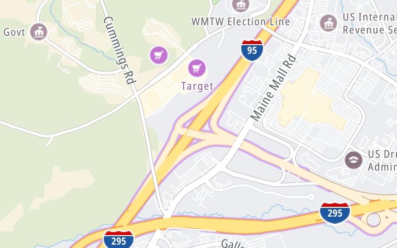
This location's approximate GPS Coordinates are 43.63208 x -70.34413.
Which directions can I travel from here?
From this junction, traffic can enter traveling both southbound and northbound. Traffic can also exit traveling both southbound and northbound.
On to Portland Int'l Jetport (PWI) / ME 22, about 1.4 miles away ►
◄ Back to I–295, about 0.7 miles away.
Which direction are tolls charged here?
The interactive map and lists on this page include key traveler services within two miles of this destination point.
You will find common services, including gas stations, truck stops, EV charging facilities, fast-food or family restaurants, and hotels. These are displayed on the interactive map as markers, which you can select for more information.
Current driving conditions and weather, along with a more complete list of key services, may be found below the map.
Static map. Interactive map is above.Sunny
69°F / 20.5°C
Feels Like:
79°F / 26.1°C
Visibility
28 Mi / 45.1 Km
3-Hour Precip:
0 In / 0.0 Cm
North Northeast
Winds (NNE)
4 MPH / 6.5 KPH
Gusts:
8.9 MPH / 14.3 KPH
▸ Get the full forecast for This Location | The Portland area
There is no currently-available traffic camera feed for this location.
There are no currently-available photos for this location.
The map above shows all services within about a two (2) mile radius.
Destination Travel
Closest Gas Stations
SUNOCO
425 Gorham Road • 0.61 miles
Store/Fuel Brand: Sunoco
SAM'S CLUB
440 Payne Road • 0.64 miles
Store/Fuel Brand: Sam's Club
CUMBERLAND FARMS
441 Payne Road • 0.78 miles
Store/Fuel Brand: Cumberland Farms
CITGO
446 Western Avenue • 1.07 miles
Store/Fuel Brand: Citgo
Closest EV Chargers
Closest Fast Food
Fast food refers ONLY to quick-service and take-out diners. All restaurant types are shown on the map above.
TACO BELL
400 Gallery Boulevard • 0.49 miles
KFC
400 Gallery Boulevard • 0.49 miles
LITTLE CAESARS
200 Gallery Boulevard • 0.51 miles
POPEYES
291 Maine Mall Road • 0.51 miles
AUNTIE ANNE'S
364 Maine Mall Road • 0.52 miles
PANDA EXPRESS
364 Maine Mall Road • 0.52 miles
AMATO'S
364 Maine Mall Road • 0.53 miles
CHARLEYS PHILLY STEAKS
364 Maine Mall Road • 0.54 miles
Journey to key destinations around and adjacent to Maine!
Communities in this metro area include Portland, Scarborough, and Biddeford.
Individual toll maps for this region are listed below.
Communities in this metro area include Augusta, Gardiner, Farmingdale, and Manchester.
Individual toll maps for this region are listed below.
Communities in this metro area include Portsmouth, Dover, Durham, Rochester, Kittery, Maine, and York, Maine.
Individual toll maps for this region are listed below.