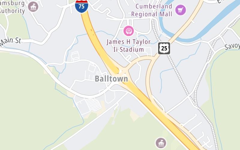
Interactive map shows available cameras, plus nearby fuel, food and lodging
See below for more about this area
This is Exit 11 of I-75.
This surface highway is located in Williamsburg.
This location's approximate GPS Coordinates are 36.72436 x -84.16644.
Above: Map image © TomTom Intl BVThe interactive map above and lists on this page below include key traveler services within two miles of this location.
You will find common services, including gas stations, truck stops, EV charging facilities, fast-food or family restaurants, and hotels. These are displayed on the interactive map as markers, which you can select for more information.
Current weather and driving conditions may be found below.
Clear
51°F / 10.6°C
Feels Like:
54°F / 12.1°C
Visibility
10 Mi / 16.1 Km
3-Hour Precip:
0 In / 0.0 Cm
Northeast
Winds (NE)
0.5 MPH / 0.9 KPH
Gusts:
0.6 MPH / 1 KPH
▸ Get the full forecast for This Location
There is no currently-available traffic camera feed for this location.
There are no currently-available photos for this location.
The map above shows all services within about a two (2) mile radius.
Destination Travel
Closest Gas Stations
STOP N SHOP
856 South Highway 25 West • 0.83 miles
Store/Fuel Brand: Exxon
HARVEYS SERVICE STATION
677 South Highway 25 West • 0.98 miles
Store/Fuel Brand:
SHELL
4039 North 2nd Street • 1.39 miles
Store/Fuel Brand: Shell
BP
755 West Highway 92 • 532 feet
Store/Fuel Brand: BP
Closest EV Chargers
WALMART - WILLIAMSBURG
589 West Highway 92 • 1,737 feet
CONNECTOR: Chademo
POWER: 150 KW @ 400 V
CURRENT: 375 Amp DC
PILOT TRAVEL CENTER - WILLIAMSBURG, KY
481 West Highway 92 • 868 feet
CONNECTOR: IEC62196Type1CCS
POWER: 350 KW @ 875 V
CURRENT: 400 Amp DC
Closest Fast Food
Fast food refers ONLY to quick-service and take-out diners. All restaurant types are shown on the map below.
HUNT BROTHERS PIZZA
1710 Main Street • 0.73 miles
LITTLE CAESARS
995 South Highway 25 West • 0.74 miles
CHICK-FIL-A
6178 College Station Dr • 0.85 miles
ROBERTS DINING HALL
Main Street • 0.89 miles
KFC
75 West Highway 92 • 1,171 feet
BURGER KING
579 West Highway 92 • 1,246 feet
TACO BELL
604 Ky-92 • 1,433 feet
COOK OUT
510 West Highway 92 • 1,942 feet
Turnpikes.com has partnered with Tiqets.com to bring you these vacation values!
Journey to key destinations around and adjacent to Kentucky!
Communities in this metro area include Louisville and Jeffersonville, Indiana.
Individual toll maps for this region are listed below.
Communities in this metro area include Cincinnati, Norwood, Cheviot, Northbrook, Reading, Covington, Kentucky, and Newport, Kentucky.
Individual toll maps for this region are listed below.
Roads Within Region