Kansas Turnpike At Turner Diagonal / College Parkway

Advertising
Advertising

Map & services within two (2) miles

Interactive map shows available cameras, plus nearby fuel, food and lodging

See below for more about this area

Advertising
Advertising

About This Location

Turner Diagonal / College Parkway
Map image © TomTom Intl BV

At A Glance

This is Exit 415/415A of the Kansas Turnpike.

This junction is located in Kansas City.

This location is in the Kansas City - Topeka area.

Interactive Map Above

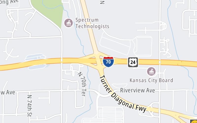
This location's approximate GPS Coordinates are 39.10612 x -94.73923.

Which directions can I travel from here?

From this junction, traffic can enter traveling both southbound and northbound. Traffic can also exit traveling both southbound and northbound.

On to North 57th Street, about 1.7 miles away ►

◄ Back to North 78th Street, about 1.1 miles away.

This location also connects with Missouri.

Which direction are tolls charged here?

Tolls are not charged or collected at this junction.

View Map Travel Conditions


Using The POI Map

The interactive map and lists on this page include key traveler services within two miles of this destination point.

You will find common services, including gas stations, truck stops, EV charging facilities, fast-food or family restaurants, and hotels. These are displayed on the interactive map as markers, which you can select for more information.

Current driving conditions and weather, along with a more complete list of key services, may be found below the map.

View Map Weather

Static map of Kansas Turnpike at Turner Diagonal / College Parkway
Static map. Interactive map is above.
Advertising
Advertising

Travel Conditions At Turner Diagonal / College Parkway

Current Weather And Visibility

  • 18 7 10
  • Sunny

    82°F / 27.8°C

    Feels Like:

    88°F / 30.9°C

  • Visibility

    10 Mi / 16.1 Km

    3-Hour Precip:

    0 In / 0.0 Cm

  • South
    Winds (S)

    4.6 MPH / 7.4 KPH

    Gusts:

    4.6 MPH / 7.4 KPH

▸ Get the full forecast for This Location | The Kansas City - Topeka area

Available Cameras

I-70 WB AT TURNER DIAGONAL

I-70 WB AT TURNER DIAGONAL

Camera Direction: UNKNOWN. Source: MODOT - undetermined 66112

Cameras Closest To Turner Diagonal / College Parkway

Camera Direction: UNKNOWN. Source: MODOT - undetermined 66112

188 Ft

Advertising
Advertising

Travel Pictures

No photos …

There are no currently-available photos for this location.

Advertising
Advertising

Closest Food, Gas, EV And Other Services Near Turner Diagonal / College Parkway

The map above shows all services within about a two (2) mile radius.

Hotels and destinations header

Hotels & Airports

Destination Travel

Fuel, EV and convenience store header

Gas & EV Charging

Closest Gas Stations

CENEX

6863 State Avenue • 0.72 miles

Store/Fuel Brand: Cenex

Shell

SHELL

6433 State Avenue • 0.96 miles

Store/Fuel Brand: Shell

QuikTrip

QUIKTRIP

555 North 78th Street • 1.13 miles

Store/Fuel Brand: QuikTrip

Phillips 66

PHILLIPS 66

7552 State Avenue • 1.14 miles

Store/Fuel Brand: Phillips 66

View Map

Closest EV Chargers

Blink

RANDY CURNOW BUICK GMC - NON-NETWORKED

7707 State Avenue • 1.19 miles

Blink

WALGREENS - KANSAS CITY, KS #7550

7739 State Avenue • 1.29 miles

View Map

Coffee, snacks and dining header

Fast Food & Beverage

Closest Fast Food

Fast food refers ONLY to quick-service and take-out diners. All restaurant types are shown on the map above.

HUNT BROTHERS PIZZA

State Avenue • 0.72 miles

Taco Bell

TACO BELL

7337 State Avenue • 0.89 miles

KRISPY KRUNCHY CHICKEN

6433 State Avenue • 0.95 miles

PAPA JOHN'S

7361 State Avenue • 0.96 miles

HUNT BROTHERS PIZZA

6383 State Avenue • 0.98 miles

Arby's

ARBY'S

7500 State Avenue • 1.02 miles

KFC

KFC

7517 State Avenue • 1.04 miles

CAPTAIN D'S

7525 State Avenue • 1.08 miles

View Map

Discover Kansas Attractions

Advertising
Advertising

EXPLORE KANSAS

Journey to key destinations around and adjacent to Kansas!

Map Of This Region ▹

Communities in this metro area include Kansas City, Kansas City, Missouri, Topeka, Lawrence, Overland Park, Edwardsville, and Bonner Springs.

Individual toll maps for this region are listed below.

Map Of This Region ▹

Communities in this metro area include Wichita, Bel Aire, Andover, Valley Center, and Maize.

Individual toll maps for this region are listed below.

Map Of This Region ▹

Communities in this metro area include Tulsa, Broken Arrow, Muskogee, Stillwater, Sapulpa, Vinita, Joplin, Missouri, Siloam Springs, Arkansas, and San Springs.

Individual toll maps for this region are listed below.

Map Of This Region ▹

Communities in this metro area include Stillwater and Tulsa.

Individual toll maps for this region are listed below.

Advertising
Advertising
Turnpikes.com is proud to partner with the following: