Share

Kansas Turnpike At US 81

Advertising
Advertising

About This Location

US 81
Map image © TomTom Intl BV

At A Glance

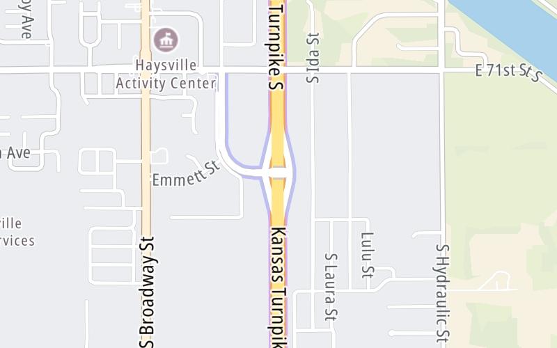
This is Exit 39 of the Kansas Turnpike.

This junction is located in Haysville. Wichita is nearby.

This location is in the Wichita - Mcconnel AFB area.

Interactive Map Below

This location's approximate GPS Coordinates are 37.55930 x -97.32576.

Which directions can I travel from here?

From this junction, traffic can enter traveling both southbound and northbound. Traffic can also exit traveling both southbound and northbound.

On to Wichita I-135/I-235/Haysville Zone Gantry, about 1.0 mile away ►

◄ Back to Haysville-Derby 71st / Mulvane Zone Gantry, about 1.9 miles away.

Which direction are tolls charged here?

  • ▸ Southbound on ramp
  • ▸ Southbound off ramp
  • ▸ Northbound on ramp
  • ▸ Northbound off ramp

View Map Travel Conditions

Closest Food, Gas, EV And Other Services Near US 81

Use the map below for all services within about a two (2) mile radius.

Fuel, EV and convenience store header

Gas & EV Charging

Closest Gas Stations

JUMP START

7200 South Broadway Street • 0.54 miles

Store/Fuel Brand:

View Map

Closest EV Chargers

View Map

No EV charging stations nearby.

Coffee, snacks and dining header

Fast Food & Beverage

Closest Fast Food

Fast food refers ONLY to quick-service and take-out diners. All restaurant types are shown on the map below.

HUNT BROTHERS PIZZA

7200 South Broadway Street • 0.52 miles

SONIC

1414 East Grand Avenue • 0.62 miles

DAYLIGHT DONUTS

868 East Grand Avenue • 0.95 miles

McDonald's

MCDONALD'S

200 North Main Street • 1.51 miles

SK DONUTS

133 North Main Street • 1.54 miles

BIONIC BURGER

243 North Main Street • 1.58 miles

GREAT WALL CHINESE RESTAURANT

360 North Main Street • 1.58 miles

LITTLE CAESARS

307 North Main Street • 1.63 miles

View Map

Advertising
Advertising

Interactive POI Map

The interactive map and lists on this page include key traveler services in a two-mile radius, including gas stations, truck stops, EV charging facilities, fast-food or family restaurants, and hotels.

Current driving conditions and weather, may be found below.

Advertising
Advertising

Travel Conditions At US 81

Current Weather And Visibility

  • 07 7 01
  • Clear

    31°F / -0.5°C

    Feels Like:

    31°F / -0.3°C

  • Visibility

    10 Mi / 16.1 Km

    3-Hour Precip:

    0 In / 0.0 Cm

  • North Northwest
    Winds (NNW)

    3.8 MPH / 6.1 KPH

    Gusts:

    7.8 MPH / 12.6 KPH

▸ Get the full forecast for This Location | The Wichita - Mcconnel AFB area

Available Cameras

No camera feed …

There is no currently-available traffic camera feed for this location.

Advertising
Advertising

Pictures At US 81

No photos …

There are no currently-available photos for this location.

Advertising
Advertising

Discover Kansas Attractions

Hotels and destinations header

Hotels & Airports

Destination Travel

Advertising
Advertising

EXPLORE KANSAS

Journey to key destinations around and adjacent to Kansas!

Map Of This Region ▹

Communities in this metro area include Kansas City, Kansas City, Missouri, Topeka, Lawrence, Overland Park, Edwardsville, and Bonner Springs.

Individual toll maps for this region are listed below.

Map Of This Region ▹

Communities in this metro area include Wichita, Bel Aire, Andover, Valley Center, and Maize.

Individual toll maps for this region are listed below.

Map Of This Region ▹

Communities in this metro area include Tulsa, Broken Arrow, Muskogee, Stillwater, Sapulpa, Vinita, Joplin, Missouri, Siloam Springs, Arkansas, and San Springs.

Individual toll maps for this region are listed below.

Map Of This Region ▹

Communities in this metro area include Stillwater and Tulsa.

Individual toll maps for this region are listed below.

Static map of Kansas Turnpike at US 81

Static map. Interactive map is above.

Advertising
Advertising
Turnpikes.com is proud to partner with the following: