Share

Connecticut Turnpike At Atlantic Street

Advertising
Advertising

About This Location

Atlantic Street
Map image © TomTom Intl BV

At A Glance

This is Exit 7 of the Connecticut Turnpike.

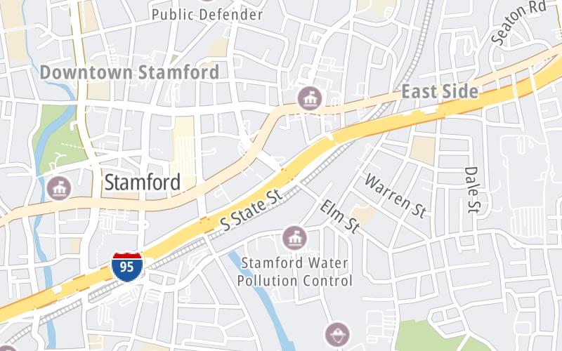
This junction is located in Stamford. NOTE: to CT 137.

Interactive Map Below

This location's approximate GPS Coordinates are 41.05217 x -73.53102.

Which directions can I travel from here?

From this junction, traffic can only enter going northbound. Traffic can only exit going southbound.

On to Elm Street, about 0.5 miles away ►

◄ Back to Atlantic Street / Canal Street, about 0.7 miles away.

Which direction are tolls charged here?

Tolls are not charged or collected at this junction.

View Map Travel Conditions

Closest Food, Gas, EV And Other Services Near Atlantic Street

Use the map below for all services within about a two (2) mile radius.

Fuel, EV and convenience store header

Gas & EV Charging

Closest Gas Stations

Shell

SHELL

179 Shippan Avenue • 0.42 miles

Store/Fuel Brand: Shell

MINI MART

314 Cove Road • 0.66 miles

Store/Fuel Brand:

BP

BP

224 Magee Avenue • 0.71 miles

Store/Fuel Brand: BP

Shell

SHELL

38 West Broad Street • 0.82 miles

Store/Fuel Brand: Shell

View Map

Closest EV Chargers

RMS COMPANIES

154 West Broad Street • 0.38 miles

BEDFORD STREET GARAGE

17 Forest Street • 0.42 miles

RFR 300 ATLANTIC

300 Atlantic Street • 0.43 miles

LANDMARK SQUARE

2 Landmark Square • 0.45 miles

View Map

Coffee, snacks and dining header

Fast Food & Beverage

Closest Fast Food

Fast food refers ONLY to quick-service and take-out diners. All restaurant types are shown on the map below.

SAUCE IT UP EATS

Edith Sherman Drive • 0.41 miles

CHOKA'S

75 Maple Avenue • 0.41 miles

TOMATILLO TACO JOINT

114 Broad Street • 0.45 miles

JUICE KINGS

36 Atlantic Street • 0.45 miles

McDonald's

MCDONALD'S

25 Bedford Street • 0.46 miles

Dunkin'

DUNKIN'

450 Main Street • 0.46 miles

LORCA COFFEE BAR

125 Bedford Street • 0.48 miles

GARDEN OF EAT'N

300 Main Street • 0.50 miles

View Map

Advertising
Advertising

Interactive POI Map

The interactive map and lists on this page include key traveler services in a two-mile radius, including gas stations, truck stops, EV charging facilities, fast-food or family restaurants, and hotels.

Current driving conditions and weather, may be found below.

Advertising
Advertising

Travel Conditions At Atlantic Street

Current Weather And Visibility

  • 07 7 01
  • Clear

    23°F / -4.8°C

    Feels Like:

    18°F / -8°C

  • Visibility

    29 Mi / 46.7 Km

    3-Hour Precip:

    0 In / 0.0 Cm

  • West Northwest
    Winds (WNW)

    6.7 MPH / 10.9 KPH

    Gusts:

    15.3 MPH / 24.7 KPH

▸ Get the full forecast for This Location

Available Cameras

I-95 NORTHBOUND EXIT 9 STAMFORD, ROUTE 1

Camera direction: NORTH. Bridgeport 18334.
Source: ConnDOT.

Camera direction: NORTH. Bridgeport 18334.<br />Source: ConnDOT -

1.07 Mi

Camera direction: SOUTH. Bridgeport 06820.<br />Source: ConnDOT -

1.70 Mi

Camera direction: SOUTH. Bridgeport 06878.<br />Source: ConnDOT -

3.03 Mi

Advertising
Advertising

Pictures At Atlantic Street

No photos …

There are no currently-available photos for this location.

Advertising
Advertising

Discover Connecticut Attractions

Hotels and destinations header

Hotels & Airports

Destination Travel

Advertising
Advertising

EXPLORE CONNECTICUT

Journey to key destinations around and adjacent to Connecticut!

Map Of This Region ▹

Communities in this metro area include New Haven, Bridgeport, Darien, Greenwich, Stamford, and Port Chester, New York.

Individual toll maps for this region are listed below.

Map Of This Region ▹

Communities in this metro area include Springfield, West Springfield, Chicopee, Westfield, and Hartford, Connecticut.

Individual toll maps for this region are listed below.

Static map of Connecticut Turnpike at Atlantic Street

Static map. Interactive map is above.

Advertising
Advertising
Turnpikes.com is proud to partner with the following: