Share

Connecticut Turnpike At High Street

Advertising
Advertising

This Location At A Glance

This is Exit 37 of the Connecticut Turnpike.

This junction is located in Milford. NOTE: NB Off/SB On.

This location is in the New Haven - Bridgeport area.

High Street
Map image © TomTom Intl BV

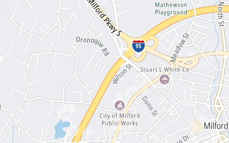
This location's approximate GPS Coordinates are 41.23038 x -73.07273.

Interactive Map Below


Which directions can I travel from here?

From this junction, traffic can only enter going southbound. Traffic can only exit going northbound.

On to CT 15/Merritt Pkwy / Wilbur Cross Pkwy, about 0.3 miles away ►

◄ Back to Plains Road, about 0.6 miles away.

Nearby gas and food are shown on the interactive map below.

View Map

Weather & Visibility

  • 00 7 04
  • Mostly Clear

    40°F / 4.5°C

    Feels Like

    42°F / 5.5°C

  • Visibility

    10 Mi / 16.1 Km

    3 Hr Precip

    0 In / 0.0 Cm

  • WNW Wind

    2.3 Mi / 3.6 Km

    Gusts

    5.8 Mi / 9.3 Km


Available Cameras

I-95 @ MILFORD PKWY

Camera direction: SOUTH. Bridgeport 06461.
Source: ConnDOT.

Camera direction: SOUTH. Bridgeport 06461.<br />Source: ConnDOT -

0.20 Mi

Camera direction: NORTH. Bridgeport 06461.<br />Source: ConnDOT -

0.67 Mi

Camera direction: SOUTH. Bridgeport 06461.<br />Source: ConnDOT -

0.69 Mi

Camera direction: SOUTH. Bridgeport 06461.<br />Source: ConnDOT -

0.88 Mi

Camera direction: SOUTH. Bridgeport 06461.<br />Source: ConnDOT -

1.20 Mi

Advertising

Closest Food, Gas, EV And Other Services Near High Street

The interactive map shows traffic cameras and services within about a two-mile radius. Not all locations have cameras.

Advertising

Discover Connecticut Attractions

Hotels and destinations header

Hotels & Airports

Destination Travel

Advertising
Advertising

EXPLORE CONNECTICUT

Journey to key destinations around and adjacent to Connecticut!

Map Of This Region ▹

Communities in this metro area include New Haven, Bridgeport, Darien, Greenwich, Stamford, and Port Chester, New York.

Individual toll maps for this region are listed below.

Map Of This Region ▹

Communities in this metro area include Springfield, West Springfield, Chicopee, Westfield, and Hartford, Connecticut.

Individual toll maps for this region are listed below.

Static map of Connecticut Turnpike at High Street

Static map. Interactive map is above.

Advertising
Advertising
Turnpikes.com is proud to partner with the following: