Connecticut Turnpike At East Avenue

Advertising
Advertising

Map & services within two (2) miles

Interactive map shows available cameras, plus nearby fuel, food and lodging

See below for more about this area

Advertising
Advertising

About This Location

East Avenue

At A Glance

This is Exit 16 of the Connecticut Turnpike.

This junction is located in Norwalk.

Interactive Map Above

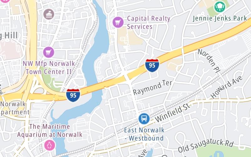
This location's approximate GPS Coordinates are 41.10845 x -73.40633.

Which directions can I travel from here?

From this junction, traffic can enter traveling both southbound and northbound. Traffic can also exit traveling both southbound and northbound.

On to Saugatuck Avenue/CT 33/CT 136, about 1.9 miles away ►

◄ Back to US 7, about 0.7 miles away.

Which direction are tolls charged here?

Tolls are not charged or collected at this junction.

View Map Travel Conditions

Above: Map image © TomTom Intl BV

Using The POI Map

The interactive map and lists on this page include key traveler services within two miles of this destination point.

You will find common services, including gas stations, truck stops, EV charging facilities, fast-food or family restaurants, and hotels. These are displayed on the interactive map as markers, which you can select for more information.

Current driving conditions and weather, along with a more complete list of key services, may be found below the map.

View Map Weather

Static map of Connecticut Turnpike at East Avenue
Static map. Interactive map is above.
Advertising
Advertising

Travel Conditions At East Avenue

Current Weather And Visibility

  • 05 7 04
  • Cloudy

    61°F / 16°C

    Feels Like:

    60°F / 15.6°C

  • Visibility

    14 Mi / 22.5 Km

    3-Hour Precip:

    0 In / 0.0 Cm

  • South Southwest
    Winds (SSW)

    3.3 MPH / 5.4 KPH

    Gusts:

    7.8 MPH / 12.6 KPH

▸ Get the full forecast for This Location

Available Cameras

I-95 @ EAST AVE

I-95 @ EAST AVE

Camera Direction: SOUTH. Source: ConnDOT - Bridgeport 06851

Cameras Closest To East Avenue

Camera Direction: SOUTH. Source: ConnDOT - Bridgeport 06851

162 Ft

Camera Direction: NORTH. Source: ConnDOT - Bridgeport 06854

0.43 Mi

Camera Direction: WEST. Source: ConnDOT - Bridgeport 06850

0.67 Mi

Camera Direction: SOUTH. Source: ConnDOT - Bridgeport 06850

0.89 Mi

Camera Direction: SOUTH. Source: ConnDOT - Bridgeport 06880

1.66 Mi

Advertising
Advertising

Travel Pictures

No photos …

There are no currently-available photos for this location.

Advertising
Advertising

Closest Food, Gas, EV And Other Services Near East Avenue

The map above shows all services within about a two (2) mile radius.

Hotels and destinations header

Hotels & Airports

Destination Travel

Fuel, EV and convenience store header

Gas & EV Charging

Closest Gas Stations

PRAMER FUEL

35 Harbor Avenue • 0.40 miles

Store/Fuel Brand:

Mobil

WEST AVENUE NORWALK

331 West Avenue • 0.60 miles

Store/Fuel Brand: Mobil

Shell

WEST AVENUE SHELL

94 West Avenue • 0.75 miles

Store/Fuel Brand: Shell

Mobil

NORTH AVENUE CONVENIENCE MART

31 North Avenue • 0.92 miles

Store/Fuel Brand: Mobil

View Map

Closest EV Chargers

EAST NORWALK LIBRARY

51 Van Zant Street • 0.44 miles

CONNECTOR: IEC62196Type1
POWER: 7 KW @ 240 V
CURRENT: 30 Amp AC1

AmpUp

QUINCY LOFTS PARKING GARAGE

26 Orchard Street • 0.46 miles

CONNECTOR: IEC62196Type1
POWER: 11 KW @ 240 V
CURRENT: 48 Amp AC1

AmpUp

515 WEST AVENUE - GARAGE

515 West Avenue • 0.52 miles

CONNECTOR: IEC62196Type1
POWER: 11 KW @ 240 V
CURRENT: 48 Amp AC1

AmpUp

TEA HOUSE EV CHARGER - 3RD FLOOR GARAGE

11 Merwin Street • 0.52 miles

CONNECTOR: IEC62196Type1
POWER: 11 KW @ 240 V
CURRENT: 48 Amp AC1

View Map

Coffee, snacks and dining header

Fast Food & Beverage

Closest Fast Food

Fast food refers ONLY to quick-service and take-out diners. All restaurant types are shown on the map above.

CAFé OUI

141 West Avenue • 0.69 miles

OVERTON'S

80 Seaview Avenue • 0.71 miles

MR. FROSTYS ICE CREAM

6 1st Street • 0.74 miles

CAFETERIA

5 Maple Street • 0.82 miles

KENNYS FOOD TRUCK

22 Main Street • 0.85 miles

WAVE HILL BREADS

30 High Street • 0.89 miles

McDonald's

MCDONALD'S

26 Belden Avenue • 0.89 miles

BLUE CACTUS GRILL

51 Stevens Street • 0.95 miles

View Map

Discover Connecticut Attractions

Advertising
Advertising

EXPLORE CONNECTICUT

Journey to key destinations around and adjacent to Connecticut!

Map Of This Region ▹

Communities in this metro area include New Haven, Bridgeport, Darien, Greenwich, Stamford, and Port Chester, New York.

Individual toll maps for this region are listed below.

Map Of This Region ▹

Communities in this metro area include Springfield, West Springfield, Chicopee, Westfield, and Hartford, Connecticut.

Individual toll maps for this region are listed below.

Advertising
Advertising
Turnpikes.com is proud to partner with the following: